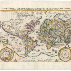
1707 exploration map set in a decorative border
H. Benzos Scheep-togt uit Italie over Spanje na de Westindize Eylanden, en Kusten van’t Zuider America
Out of stock
Description
This lovely map of the Atlantic Ocean depicts the route of explorer Hieronymus Benzo, who traveled from Spain to the Americas, and back to Italy from 1541-56.
The map includes large portions of North America, South America and Africa. Many of the cartographic myths at the turn of the eighteenth century are also shown, including a large inland lake in the Carolinas, an inaccurate depiction of the Great Lakes, and Parime and Xarayes (not named) Lakes in South America.
The map is adorned with a vignette of the European explorers and natives, and surrounded by a decorative picture frame border.
Cartographer(s):
Condition Description
A strong, dark impression on a clean sheet. There is a tiny, professionally repaired tear along the top edge of the sheet.
References