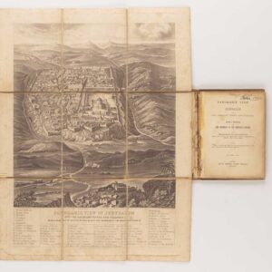
1582 town-plan of Jerusalem
Hierosolymia, Clarissima totius Orientis civitas…
Out of stock
Description
Two bird’s-eye-perspectives on one sheet. The left plan shows ancient Jerusalem at the time of Christ.
A contemporary view of Jerusalem appears to the right with an attractive vignette in the lower right corner of Moses receiving the Tablets.
Cartographer(s):
Georg Braun (1541–1622) was a German geographer, publisher, and the canon of the Cologne chapter of St. Maria ad Gradus. From 1572, he edited the Civitates orbis terrarum, which contains 546 prospects, bird’s-eye views, and maps of cities from all around the world. As the principal editor, Braun acquired the tables, hired the various artists and contributors, and wrote the texts. He oversaw the project from its inception until its completion in 1617.
The main engraver for volumes I-IV of the Civitates orbis terrarum was Frans Hogenberg (1535–1590), a Flemish painter, engraver, and mapmaker, born in Mechelen and later established in Cologne. Hogenberg was a Protestant exile from the Spanish Netherlands who had worked with Abraham Ortelius on his iconic Theatrum Orbis Terrarum. His detailed depictions of architecture, figures, and heraldry helped define the genre of the Renaissance bird’s-eye view. By the time of his death in 1590, Hogenberg had secured his reputation as one of the era’s foremost cartographic artists.
Condition Description
Excellent impression.
References
Laor, 1039.
![[Unusual Jerusalem engraving / proof]](https://neatlinemaps.com/wp-content/uploads/2025/06/NL-02380_thumbnail-300x300.jpg)