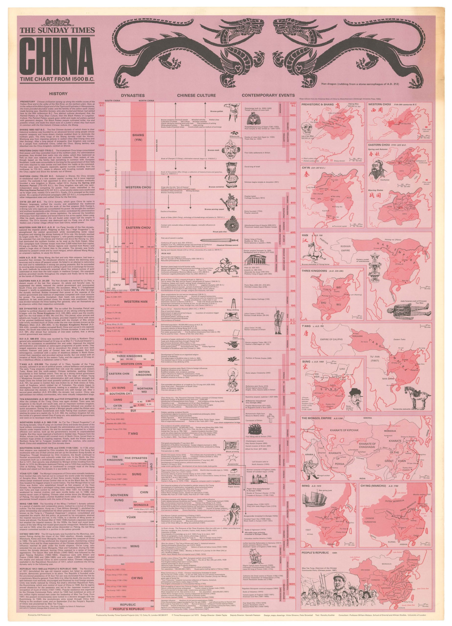
Locating Ptolemy on a contemporary map: 19th century map of India and Southeast Asia with classical references.
India int. Gangem merid., India ext. Gangem, Sinarum situs.
Out of stock
Description
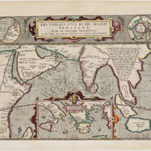
This unusual map offers a fascinating rendition of ancient place names upon an excellent map of India and Southeast Asia. The title itself makes reference to Ptolemy and other classical sources, who divided India as that within (west of) the Ganges River, and that beyond (east of) it. The classical notion of the riches of the East, an idea excitedly promoted during the European Renaissance, is on full display. Just to the east of the delta of the Ganges (about modern-day Burma) is a region labeled ‘Aurea regio,’ a kingdom of gold. Adjacent is ‘Argentae regio,’ kingdom of silver.
In the area of Hong Kong, the mapmaker has placed Cattigara, the celebrated entrepôt said to be fabulously wealthy, the location of which was a source of cartographic speculation for centuries.
Other ancient places names include: Bonae Fortunae (Sumatra), Cheryse sive Aurea Chersonesus (Malay; The Golden Cheronese, which Ptolemy stressed was of great importance), Taprobane Insula (Sri Lanka), and Maniolae Insulae (the Philippines).
The labeling of Borneo as Ichthyophagi Aethiopes has a fascinating backstory, steeped in classical tradition. The term means ‘fish-eating Ethiopians,’ whom mapmakers placed not just in East Africa, but in various places in Asia as well. This is because Homer had described them as being in the furthest outposts of the known world.
Cartographer(s):
Christian Gottlieb Reichard (1758-1837) was a German legal scholar who, despite his profession as a town clerk in Bad Lobenstein, developed a profound passion for geography, history, and cartography. His interest soon overshadowed his legal career, leading him to pursue cartographic endeavors alongside his clerical duties.
Reichard’s most notable contributions to cartography include the creation of the Atlas des Ganzen Erdkreises in der Central Projection (Atlas of the Whole World in the Central Projection) in 1803 and the Orbis terrarum antiquus (Atlas of the Ancient World) in 1824. Additionally, he is credited as one of the earliest cartographers to use the Albers conic projection.
Reichard’s maps were renowned for their exceptional accuracy during his time. His meticulous attention to detail and straightforward style made his output highly sought after for publication, leading him to collaborate with fellow cartographers on famous atlases, such as Stieler’s Handatlas.
Condition Description
Very good. On contemporary linen.
References
OCLC Number: 457649410.
![[Cook’s Discovery of Eastern Australia] Carte de la Nle. Galles Merid. ou de la Cote Oriental de la Nle. Hollande.](https://neatlinemaps.com/wp-content/uploads/2021/12/NL-01183_Thumbnail-300x300.jpg)
![[Cook’s Discovery of Eastern Australia] Carte de la Nle. Galles Merid. ou de la Cote Oriental de la Nle. Hollande.](https://neatlinemaps.com/wp-content/uploads/2021/12/NL-01183_Thumbnail.jpg)
![[Sri Lanka] Tabula Duodecima Dasia](https://neatlinemaps.com/wp-content/uploads/2023/03/NL-01721_thumbnail-300x300.jpg)