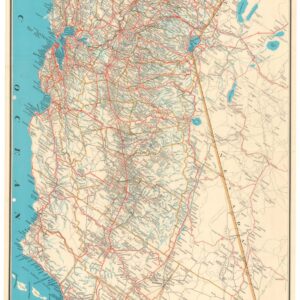
A Scarce Early 20th Century Survey Map of Northern California.
Map of the Sacramento Land District.
$500
In stock
Description
A rare map produced to indicate vacant and government-owned lands in Northern California, including portions or the entirety of Siskiyou, Trinity, Shasta, Tehama, Glenn, Butte, Plumas, Sierra, Yuba, Sutter, Colusa, Nevada, Placer, Yolo, Napa, Lake, Solano, El Dorado, Sacramento, Amador, Merced, Mariposa, and Madera Counties. It is overlaid with a grid to demonstrate the area of townships, sections, and quarters of land.
Census
This map appeared in the small booklet The Homeseeker’s Guide to Government Lands: Sacramento Land District, State of California, published in 1915 to attract farmers to Northern California and the Central Valley. Only three institutions are listed as holding the booklet and map in the OCLC (774622019).
Cartographer(s):
Condition Description
Wear and significant repairs visible, with some areas of loss and infill.
References