San Francisco transforms into a city.
City of San Francisco and Its Vicinity.
Out of stock
Description
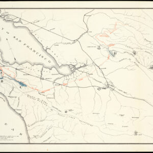
Published just a few years after the California Gold Rush, this is a gorgeous U.S. Coast Survey map of San Francisco. The level of detail is astounding, with micro-printed individual buildings and topographic precision.
The discovery of gold at Sutter’s Mill in 1848 and the subsequent influx of prospectors from around the world completely transformed San Francisco from the sleepy village of Yerba Buena to a city of over 40,000 residents. At the same time, the American victory over Mexico brought California into the United States, first as a territory and then as a state in 1850. Up-to-date and accurate maps were a must, and the U.S. Coast Survey made a series of critical charts of northern California in the 1850s.
As expected, the most densely built-up section of the city is along the water front in today’s financial district. The original town plaza was Portsmouth Square, not Union Square, which has no buildings on this map. A series of wharves extent from the waterfront out into San Francisco Bay. The waters near the shore were shallow, and the city expanded out into the bay through the auctioning and filling of water lots, and the extension of docks to deeper waters. One such dock was Central Wharf, which extended out from Commercial Street.
This map is also fascinating because it depicts areas that haven’t yet been developed. Beyond the western edge of the urban street grid at Taylor St., we see the contour lines of Russian and Nob Hills, followed by the bucolic plain of today’s Cow Hollow and Marina District. Exiting from about Mason and Broadway, we see the old Presidio road, a path connecting the original military garrison at the Presidio to the original maritime settlement of Yerba Buena. It follows a path likely used by Native Americans for millennia, as it is here that there is a slight dip between the heights of Russian and Nob Hill (even today, the best bike route over this area follows Pacific Ave). The Presidio road travels northwest towards the upper left corner of the map into an area known as Spring Valley. Partially extending out of the mapped area is Washerwoman’s Bay, a freshwater lagoon located around today’s Lombard, Filbert, Gough, and Octavia Streets. This became the site of a lucrative laundry industry until it became over-used and polluted, leading to several cases of cholera. The lagoon no longer exists because it was filled in by prisoners from the local jail in 1877; its memory survives in the name of Laguna St.
The original civilian settlement (as opposed to the military encampment at the Presidio) was the religious community at the Mission San Francisco de Asís, popularly known as Mission Dolores after a nearby creek named Arroyo de Nuestra Señora de los Dolores, meaning “Our Lady of Sorrows Creek.” As our map shows in dramatic detail, the center of gravity has shifted 2.6 miles northeast to Yerba Buena Cove at what could then be described as the distinct settlement of San Francisco, but a Plank Road connects the two. Plank roads were built by driving long tree trunks (usually redwoods from Marin County) deep into marshland, one after another, to create a passable walkway. They were often paid toll roads. The Mission Plank Road, as the name suggests, followed the line of today’s Mission St. It was built in 1850 with private funding.
The Mission itself is shown to be a small community dominated by the church, with an exhibition ring that featured such spectacles as duels and bull vs. bear fights located opposite. The natural landscape is still recognizable — indeed, this is one of the last maps before this area becomes drastically altered — with marshlands and small creeks extending well into today’s Mission neighborhood. The preferred alternative to travel from downtown San Francisco to the Mission was by boat, south around Steamboat Point (near the Giants baseball stadium today), into Mission Bay, and up Mission Creek to various docks in the marshes. From there, it was a short walk up what would become today’s 16th Street.
Cartographer(s):
The Office of Coast Survey is the official chartmaker of the United States. Set up in 1807, it is one of the U.S. government’s oldest scientific organizations. In 1878 it was given the name of Coast and Geodetic Survey (C&GS). In 1970 it became part of the National Oceanic and Atmospheric Administration (NOAA).
The agency was established in 1807 when President Thomas Jefferson signed the document entitled “An act to provide for surveying the coasts of the United States.” While the bill’s objective was specific—to produce nautical charts—it reflected larger issues of concern to the new nation: national boundaries, commerce, and defense.
Alexander Dallas Bache, great-grandson of Benjamin Franklin, was the second Coast Survey superintendent. Bache was a physicist, scientist, and surveyor who established the first magnetic observatory and served as the first president of the National Academy of Sciences. Under Bache, Coast Survey quickly applied its resources to the Union cause during the Civil War. In addition to setting up additional lithographic presses to produce the thousands of charts required by the Navy and other vessels, Bache made a critical decision to send Coast Survey parties to work with blockading squadrons and armies in the field, producing hundreds of maps and charts.
In 1871, Congress officially expanded the Coast Survey’s responsibilities to include geodetic surveys in the interior of the country, and one of its first major projects in the interior was to survey the 39th Parallel across the entire country. Between 1874 and 1877, the Coast Survey employed the naturalist and author John Muir as a guide and artist during the survey of the 39th Parallel in the Great Basin of Nevada and Utah. To reflect its acquisition of the mission of surveying the U.S. interior and the growing role of geodesy in its operations, the U.S. Coast Survey was renamed the United States Coast and Geodetic Survey (USC&GS) in 1878.
Condition Description
Good. Even toning. Wear, creasing, and repaired tears around the edges and margins. Rebacked.
References
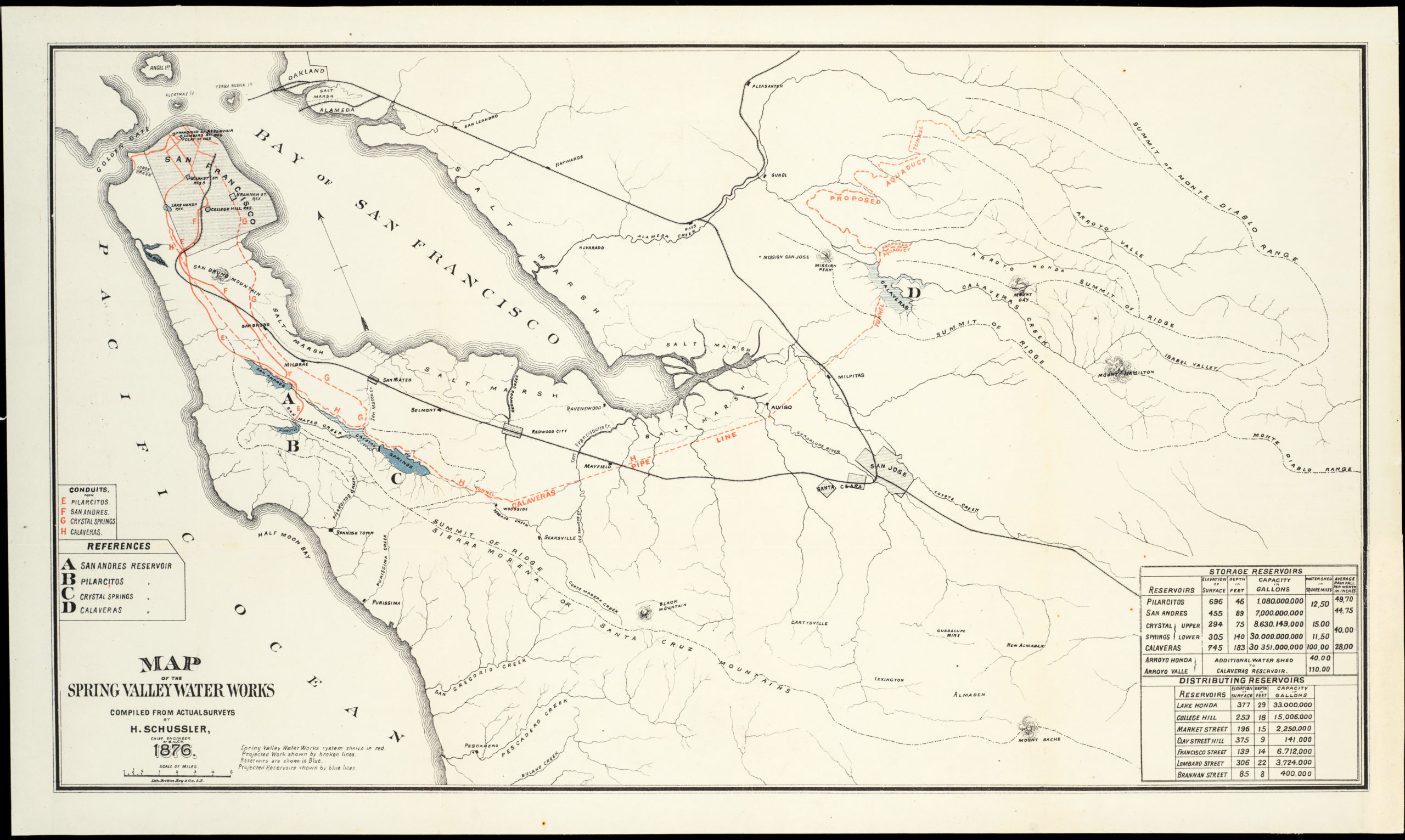
![5-sheet set showing San Francisco’s post-1906 earthquake water supply [SF’s first fireboat!]](https://neatlinemaps.com/wp-content/uploads/2022/03/NL-01375-sheet-4_thumbnail-scaled-300x300.jpg)
![5-sheet set showing San Francisco's post-1906 earthquake water supply [SF's first fireboat!]](https://neatlinemaps.com/wp-content/uploads/2022/03/NL-01375-sheet-4_thumbnail-scaled.jpg)