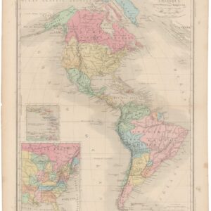
Rare and early school atlas map of the Americas.
Untitled [Western Hemisphere]
Out of stock
Description
This quaint and decorative little map depicts the Americas under colonial rule. This includes a representation of North America as it appeared prior to the Revolutionary War. The map was compiled by German educator, priest, and mapmaker Jakob Friedrich Klemm and was published in his seminal Neuer Atlas für die Jugend (1782). Despite being published years after the Declaration of Independence had been signed, the map captures a situation more or less as it was immediately prior to this dramatic reconfiguration of political power in North America.
Klemm’s atlas was one of the first educational atlases intended specifically for school children. School atlases were an innovation that generally dates to the late 18th century. As their purpose was to educate children in geography, the maps were often simplified compilations not designed to incorporate the latest developments and knowledge. On the contrary, in fact, these atlases mostly sought to convey established geographical facts and thus tended to be conservative in their outlook.
A colonial North America
While the Americas are shown in their entirety, the most interesting subject matter for us is North America. It is clear from the subdivision and labeling of the northern continent that it remains in a fully colonized state. The United States does not yet exist, and the East Coast remains squarely under the purview of British colonial rule. The rest of North America is configured in a similar Pre-Revolutionary state, albeit not always correctly so.
British colonies are displayed in pink along the East Coast, whereas the heartland of America remains under French dominion as Greater Louisiana. Florida, which at this stage remains part of New Spain, has been misplaced so that it extends from Georgia into Arkansas but does not include the actual panhandle. Mexico is divided into old and new, while California has been colored a vivid green to distinguish it from the rest of Mexico, perhaps a lingering effect of the centuries-long debated over California as an Island.
Maps as educational tools
The educational aspect of this map is evidenced by the sub-division of the continents, the careful depiction of islands and archipelagos, and not least the application of an exclusively German toponymy. The delineation of the tropics of Cancer and Capricorn, the Equator, and the Arctic Circle also underscore this aspect of the map. As is often the case in cartography, the presence of certain features says almost as much as the omission of others. In this regard, it is interesting to note some of the details that are not included on our map. This is perhaps best exemplified by the large parts of Canada and the Pacific Northwest that remain completely obscure.
Engaging the youth and kindling a geographic curiosity in them was key for Klemm, and his attempts to do so were not restricted to the creation of maps alone. In the associated text of the atlas, Klemm endeavors to draw in the youth by composing his text in the form of a conversation loaded with the types of questions that he imagined inquisitive children might have. Klemm’s inventiveness and unusual pedagogical outlook is manifested clearly in the fact that the original atlas included a wooden box with drawers containing maps glued to cardboard and cut into tiles so that they could be laid out like a puzzle. This idea of making a learning process fun and engaging was not just avant-garde but a complete paradigm shift in thinking about education.
Concluding remarks
Ultimately, Klemm’s map of the Americas is a charming, almost nativistic capture of the state of affairs leading up to the Revolutionary War. The map embodies an interesting dichotomy: On the one hand, we know that this was one of the first opportunities for German school children to learn about the geography of America from dedicated educational maps. On the other, they were being presented with an antiquated state of affairs that neglected to convey just how decisive the American rebellion was.
Despite being published a full six years after the Declaration of Independence was signed, it was still a full year prior to the British surrender of their American colonies. We are, in other words, in the thick of it, experiencing decisive historical events from the perspective of a late 18th-century school child.
Cartographer(s):
Jakob Friedrich Klemm (1733-1793) was a German parish priest in Tübingen who was keenly interested in the pedagogical approach to children’s education and who strongly advocated for comprehensive reforms of the German school system. He founded the new Secondary school in Germany (Realschule) and published educational books on Latin, Hebrew, and geography.
Klemm is perhaps most famous for his Neuer Atlas für die Jugend (1782), which is among the first school atlases ever produced and has been attributed to the invention of cartographic puzzles.
Condition Description
Very good. A couple of minor pin-sized holes at the top margin.
References