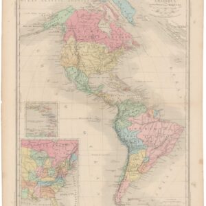
The SDUK’s map of British North America highlighting disputed borders.
British North America.
Out of stock
Description
A finely-executed Society for the Diffusion of Useful Knowledge (SDUK) map of British North America in the year 1834. The term “British North America” refers to the territories in North America that were under British control during the colonial period. It generally encompasses the regions that eventually became Canada, as well as some parts of the United States.
California is still part of Mexico and Alaska is still part of Russia.
The map stretches east-west from the maritime provinces of New Brunswick, Nova Scotia, and Prince Edward Island to Rupert’s Land and the North-Western Territory. The former were regions that saw significant fishing, shipbuilding, and trading activities. The latter were controlled by the Hudson’s Bay Company and later transferred to the Canadian government in 1869-1870.
We see significant indications of territories and tribal lands of various Indigenous peoples across British North America, representing their presence and influence in the region. But centuries of colonial influence has left a powerful mark on the region, with British military forts, trading posts, and settlements all plotted. These locations played crucial roles in defense, trade, and administration.
Cartographer(s):
Baldwin & Cradock were prominent publishers based in London during the 19th century. The publishing firm was established by Robert Baldwin and George Cradock in 1811. They specialized in producing and distributing a wide range of books, including works of literature, reference books, educational materials, and scientific publications.
Baldwin & Cradock gained a reputation for publishing high-quality books and attracting esteemed authors. They were known for their commitment to intellectual pursuits and sought to provide the public with access to valuable and informative literature.
The firm’s catalog included works from various genres, including fiction, poetry, history, philosophy, and natural sciences. They published renowned authors such as Sir Walter Scott, Thomas Babington Macaulay, Charles Lamb, and Samuel Taylor Coleridge, among others. Their publications ranged from scholarly texts to popular novels, catering to a diverse readership.
In addition to their literary endeavors, Baldwin & Cradock were active in promoting educational materials. They published textbooks, dictionaries, encyclopedias, and atlases, contributing to the dissemination of knowledge and the advancement of learning.
Baldwin & Cradock maintained a prominent presence in the publishing industry for several decades. However, like many publishing houses of the time, they faced financial challenges, especially with the emergence of newer publishing firms and changing market dynamics. In the 1840s, the firm went through a series of changes and mergers before finally dissolving.
Despite their eventual closure, Baldwin & Cradock left a lasting legacy in the publishing world. Their commitment to publishing high-quality works and promoting education contributed to the cultural and intellectual landscape of the 19th century. Many of their publications remain notable and sought after by collectors and scholars today.
Society for the Diffusion of Useful Knowledge (SDUK)The Society for the Diffusion of Useful Knowledge (SDUK) was a learned society and publishing organization founded in London in 1826. Its primary objective was to promote and disseminate practical and educational information to the general public. The society aimed to bridge the gap between academia and the wider population by making knowledge accessible and useful to all.
The SDUK had a diverse range of activities and publications, including maps, atlases, and books on various subjects. Its most notable contributions were in the field of cartography. The society produced a series of highly detailed and informative maps covering different regions of the world. These maps were widely praised for their accuracy and became popular reference materials.
The maps published by the SDUK were known for their distinctive style. They often incorporated detailed topographical information, including rivers, mountains, cities, and major landmarks. The maps also featured transportation routes, such as roads, canals, and railways, reflecting the growing importance of transportation in the 19th century.
Condition Description
Good. Uneven toning in margins and wear along edge.
References