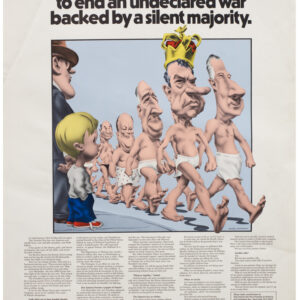
Don Bloodgood’s hilarious ‘realm of the American motorist’ and the not-so-subtle marketing of the Shell Oil Company.
Ask Shell! / Tour with Confidence with Shell
$150
In stock
Description
This wonderful mid-century map depicts an imagined and cartoonish landscape full of people and activities associated with the American motoring experience. Unlike normal maps, Bloodgood’s representation does not show us anywhere in particular. In fact, the entire composition is designed to leave viewers with a distinct impression of atmosphere but no actual locations that anchor the image geographically.
Despite its departure from geography, the composition is imbued with the spirit of the American West, incorporating recognizable elements such as dude ranches for urban cowpokes and verdant picnic havens for families on the go. The purpose of Bloodgood’s whimsical composition is to warn of all the potential scenarios that face a heedless driver crossing the country and to direct unlucky or unprepared travelers to America’s most reliable gas point and wayfinding beacon: the iconic Shell Station.
The tableau includes a diverse array of American landscapes, spanning from majestic peaks, across arid expanses, to green plains. Interspersed in the varied landscape, we find all forms of human activity – especially those related to road travel or family holidays. A river running through the front of the composition is brimming with all manner of activities. Motor boats, row boats, sailboats, canoes, and rafts are but some of the many ways in which people find leisure and recreation on the water. But this is a road map, after all, and the entity that commissioned it is an oil company, so the real focus is on all the little misgivings that can happen on the road, and for which Shell has a suitable answer.
What at first glance may appear to be an enchanting vision of cross-country travel, in fact, camouflages a subtle admonition against vehicular negligence. Blending into the map’s bustling composition, we find depictions of stranded wayfarers and ailing automobiles throughout. A total of 14 scenes have been incorporated into the larger image, each of which represents a particular roadside problem that Shell has an answer to. All of the individual issues are specified on the verso, which includes a reduced line drawing of the poster in which the fourteen scenes have been labeled, and both the problem and solution are described in a legend underneath.
For example, the traveler who ignored a headlamp malfunction and consequently steers amiss in a dark tunnel (5). A common silver thread in motorists’ issues is a lack of preparation or forethought. The car owner being towed (3), for example, could have averted this predicament by checking the oil more diligently, whereas others have failed to provide their automobiles with the appropriate lubrication (6 & 8). Thus, while the front provides a vivacious and humorous take on the many challenges facing an unprepared vehicle and motorist on the American highways, the verso stipulates actual solutions and safeguards, all provided by the reliable and omnipresent Shell.
Don Bloodgood’s humorous condensation of the American road experience into a single image is not only a brilliant way of advertising Shell’s services and products but an approach that merges marketing with cartography and cartoons. In addition to creating a template for other pictorial map creators to follow, Bloodgood’s poster is an amusing contemplation on the trials and tribulations encountered by the intrepid early adventurers of the road.
Context is Everything
The roots of the Shell Oil Company trace back to its inception in 1907. Founded as a subsidiary of the Royal Dutch Shell group, the company swiftly grew to prominence within the burgeoning petroleum industry. Responding to increasing demand for fossil fuels, Shell’s early years were marked by exploration, extraction, and the production and distribution of oil products. Throughout the 20th century, Shell Oil sought to expand globally, adapting to the evolving energy landscape. From weathering the challenges of two world wars and massive geopolitical shifts to navigating the oil crises of the 1970s, Shell remained a steadfast player in the energy sector. Moreover, the company’s commitment to research and development led to breakthroughs in extraction and refining technologies.
Emerging as a pivotal force in the American energy landscape, Shell’s legacy in the United States spans decades of transformative influence. The company’s foray into the American market gained momentum with its acquisition of oil fields and refineries, solidifying its position as a key contributor to the nation’s energy security. More recently, Shell has moved beyond conventional oil production, delving into offshore drilling and natural gas exploration.
Cartographer(s):
Don Bloodgood (1897-1989) was an American cartoonist and illustrator and a pioneer in the art of pictorial cartography. He was born in California, relocating to Arizona in 1960, at the height of his career.
Between 1935 and 1968, Bloodgood produced a substantial number of now sought-after pictorial maps, most of which depict places in the West, including California and Arizona, but also places like Alaska and Hawaii. The earliest map in this oeuvre shows San Diego and was compiled in 1935 for the California Pacific International Exposition. At the other end of the spectrum, we find his map of Navajoland, compiled in 1968 from his new home in Flagstaff, Arizona.
Condition Description
Very good. Never-folded.
References