Roberto Lagos’ map of Missions in Chile.
[Chile] Mapa de las Misiones antiguas y modernas de los PP. de S. Francesco…
Out of stock
Description
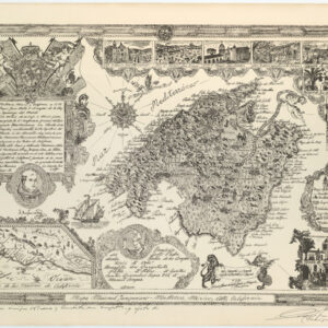
This vivacious and decorative lithographed map of Chile was produced by Roberto Lagos and issued in Barcelona in 1908 as part of his history of the Chilean missions. It shows the country divided into its three main provinces (Aramuco, Valvidia, and Chiloe), each of which are colored distinctly and labeled in thick red lettering. The primary purpose of the map is, as indicated in the title, to represent both the historic and extant missions of especially the Franciscans in Chile.
Dubbed el territorio Araucano on the map, this was the term given by Spanish conquistadors to the area controlled by the Mapuche peoples (corresponding more or less to modern Chile and western parts of Argentina). A secondary aim of the map is to delineate the gubernatorial systems that were established by the missions during the 18th century in order to establish a functioning bureaucracy.
A legend in the lower right corner of the map specifies some of the features that have been included. The primary element is the missions themselves, and these have been subdivided into historical and extant missions. The secondary node of territorial control by the missions was maintained through the presence of chapels (Capillas) – here too noted as both historic and actively functioning. Major cities and provincial centers also have symbols on the map.
Many of the missions are to be found on or near the coast. The distribution of missions reveals something about the historical development of their presence in Chile. We note, for example, the abundance of missionary sites on the archipelago of Chiloe. By the time this map was produced, however, most of these had been abandoned. Instead, focus had shifted north to the territories of Valdivia and Arauco and also inland. A note at the bottom of the legend underlines that the missionary work and infrastructure of the Valdivia region was passed from the Franciscans to the Capuchin Order in 1839.
Census
The map was prepared by P. Roberto Carlos and published in his history of Chilean mission (Historia de las Missiones del Colegio Chillan Vol. 1, 1908).
Cartographer(s):
Roberto Lagos was a Chilean historian specialized in the episcopal and missionary history of his country.
Condition Description
Wear along margins. Folding map.
References