Official map of French Equatorial Africa, with annotations for an early automobile trip across the continent.
Afrique Equitoriale Francaise – Feuille V (w/ annotations).
Out of stock
Description
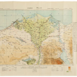
This map offers a detailed view of the eastern reaches of France’s colonial holdings in Central Africa. It was compiled and engraved in 1912 and printed in 1913 for the newly established Service Géographique de l’Afrique Équatoriale Francaise.
The map is the fifth sheet in the five-sheet edition that covered the entire federation of French colonial territories in the region (note the small inset map of the coverage in the upper right corner). In scope, it covers from N’Délé and Grimari in the east (today the Central African Republic) to the border of Anglo-Egyptian Sudan in the west and south to the borders of Belgian Congo.
Borders and the Cato River’s course have been highlighted in red. Certain quadrants in the west have also been colored bright red. This coloration forms part of a series of annotations made by the original owner of this map. In addition to the red highlighting, routes have been marked between cities in black dashed lines. A hand-written legend at the bottom confirms that these indicate routes for automobile travel. Additional handwritten notes along the edge of the map show where the suggested routes culminate (outside the map). Along the bottom, a pencil annotation notes the year 1913, the same year this map was first printed.
Context is Everything
French Equatorial Africa, known as Afrique équatoriale française (AEF) in French, was a federation of French colonial territories in Central Africa comprising Gabon, French Congo, Ubangi-Shari, and Chad. Its establishment in 1910 marked the consolidation of four colonial possessions under one administration, with Brazzaville serving as its administrative center and the Governor-General overseeing affairs with deputies in each territory.
In 1911, a portion of the territory was ceded to German Cameroun due to the Agadir Crisis, but it was later returned after Germany’s defeat in World War I. Notably, while most Cameroun proper became a French League of Nations mandate, it remained separate from AEF.
Within French Equatorial Africa, Ubangi-Shari operated under a concession system akin to the Congo Free State, where reports of atrocities surfaced, documented by writer André Gide in his 1927 publication Travels in the Congo, which strongly criticized the concession companies’ practices. The book significantly influenced France’s anti-colonialist movement. However, the exact toll of victims under the French concession system in Ubangi-Shari and other parts of French Equatorial Africa remains uncertain.
Census
The map was compiled by Sous-Lieutenant G. Delineate for the Service Géographique de l’Afrique Équatoriale Francaise under Georges Bruel. It was engraved by R. Hausermann in Paris and printed by Augustin Challamel, also in Paris.
The OCLC has no listings of this map. The map should not be confused with the map of French Equatorial Africa by Emmanuel Barralier from the same year.
Cartographer(s):
The Service Géographique de l’Afrique Équatoriale Francaise was a the French colonial administration’s survey and mapping unit. It was founded and directed by mapmaker and colonial administrator Georges Bruel (1871-1944) in 1909. After graduating from the recently established Colonial School in 1891, Bruel embarked on his administrative career in Equatorial Africa in 1893. He undertook five missions between 1895 and 1911, including Oubangui (1897) and Chari (1899-1901). Between 1902 and 1904, he commanded the Haut-Chari base and later conducted boundary delineations for major concession companies in Oubangui (1906-08). Through his explorations, he produced highly valuable reconnaissance maps.
In 1909, Bruel assumed leadership of the new geographical service of French Equatorial Africa in Brazzaville. During World War I, he was appointed head of the “Topographical Section” of the 30th Corps due to his specialized knowledge. He retired as Chief Administrator of the colonies but continued to compile reports and maps on French Equatorial Africa throughout his life.
Condition Description
Good. Some wear along fold lines.
References