A superb Edo period atlas of southern Japan.
Complete Map [Atlas] of the Provinces and Districts [of Japan] / 國郡全圖 [Kokugun Zenzu].
Out of stock
Description
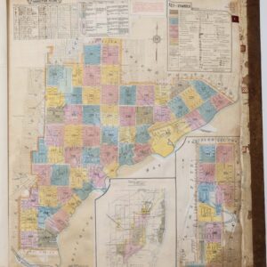
A gorgeous bound atlas of the provinces (國) of southern Japan prepared by Aō Tōkei and published in 1837. Most of the maps are printed on two facing pages, allowing for a high degree of detail. Districts (郡), cities and towns, geographic features, roads, shrines, and temples, along with bays, cliffs, and other coastal features, are noted throughout. For both aesthetic and practical purposes, the maps do not maintain a consistent orientation or scale.
The atlas is based on Nagakubo Sekisui’s (長久保赤水) late 18th century Revised Route Map of Japan (改正日本輿地路程全図), one of the most important and influential Japanese maps of the Edo period. However, as Nagakubo’s map covered the entire country, it was unable to clearly depict detail at the local level, prompting Aō Tōkei (青生東谿) to publish an atlas in two volumes (卷). Although not clearly noted here, this is the second volume, covering the southern half of Japan, form Tanba Province (丹波國) to Satsuma Province (薩摩國), as well as the islands of Tsushima and Iki.
This atlas was prepared by Aō Tōkei, also known as Ichikawa Tōkei (市川東谿). It was simultaneously published in Osaka, Kyoto, Nagoya, and Edo (Tokyo) by a group of publishers, including Kawachiya Kihei (河内屋喜兵衛), Katsumura Jiemon (勝村治右衛門), Suharaya Mohei (須原屋茂兵衛, the most prominent of the group), Suharaya Sasuke (須原屋佐助, a relation of Suharaya Mohei), and Eirakuya Tōshirō (永樂屋東四郎). The present example is a second edition, the first having been published by Eirakuya Tōshirō in 1828 (文政11年). The OCLC (1344530093) notes eleven examples held outside of Japan, while within Japan it is recorded among the holdings of seven institutions in various Japanese catalogs.
This example is in especially good condition, with tight binding, minimal wear, and no wormholes, which are very common among Japanese maps of the era.
Cartographer(s):
Condition Description
Wear along edges of cover. Surface abrasion on covers. Binding is tight. Pages are clean. Maps are on double leaves, most are printed on two facing pages.
References