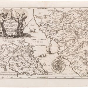
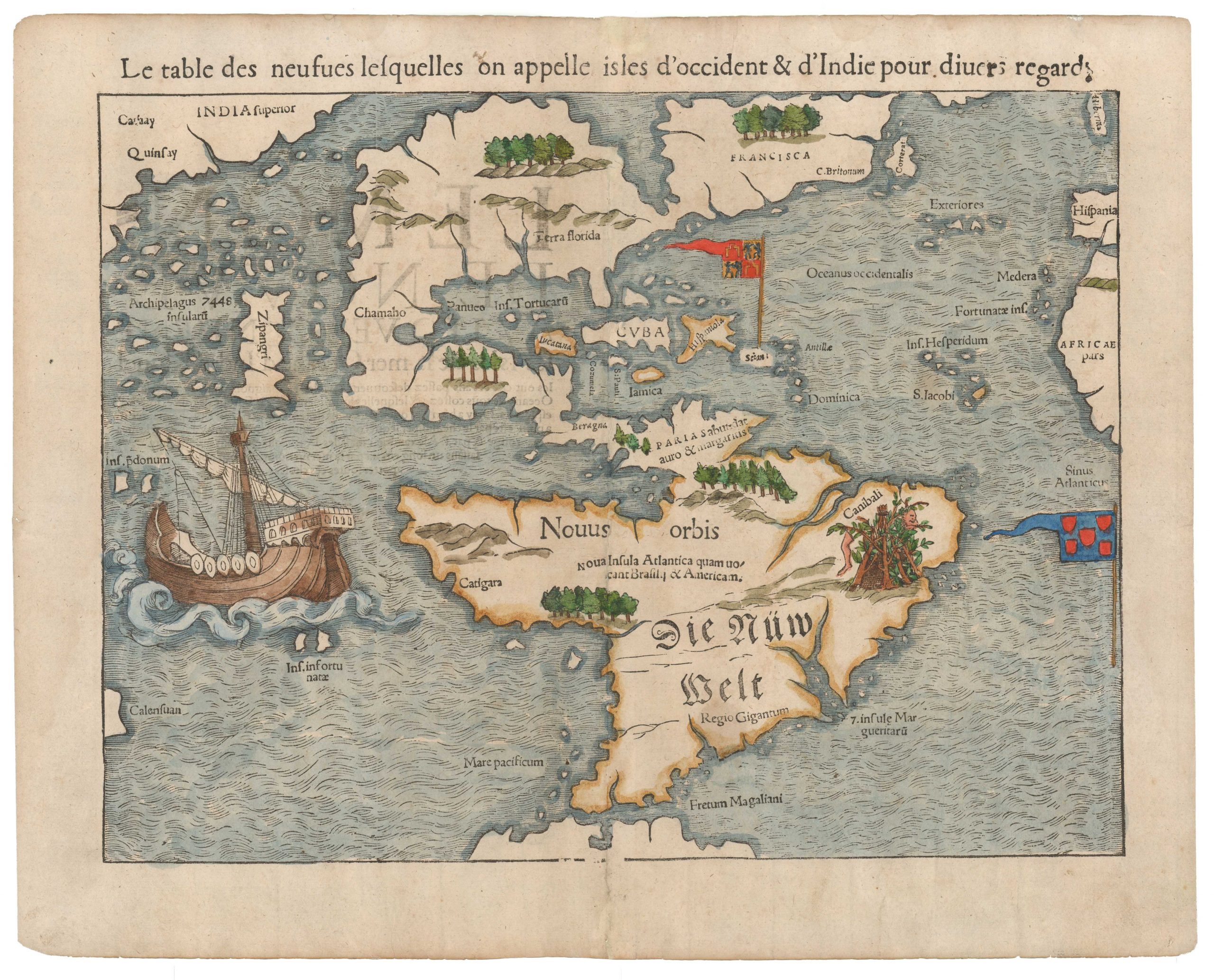
An excellent example of Coronelli’s Pacific Ocean with California as an Island.
Mare Del Sud detto altrimenti Mare Pacifico.
$2,500
1 in stock
Description
Coronelli’s 1691 map of the Pacific offers a rich blend of art, science, and speculation. It captures the Pacific Ocean and surrounding regions through the lens of 17th-century cartographic knowledge. Published in Venice, it highlights Dutch discoveries, Spanish influences, and the myths and realities that shaped contemporary understanding of the Pacific.
The map extends from the west coast of the Americas, including California as an island, down to Tierra del Fuego, and eastward to Tartary, Japan, and New Guinea. It also presents early representations of Van Diemen’s Land (Tasmania) and New Zealand, connecting them to more extensive, mysterious southern landmasses. A vast Terra de Iesso (Hokkaido) is shown to the north of Japan, illustrating Coronelli’s incorporation of real and imagined geographies influenced by Dutch expeditions.
Interwoven rhumb lines divide the Pacific, showcasing maritime navigation routes. A prominent cartouche in the upper-right corner, shaped like a clamshell, includes mermaid putti holding pearls, coral, and seaweed, symbolizing the Pacific as a realm of wealth and mystery. Nearby annotations describe prevailing winds and the vast distances across the ocean.
California as an Island
One of the map’s most notable features is its depiction of California as an island, a misconception popularized in European maps of the 17th century. The myth began with reports from Sebastian Vizcaino’s 1602 voyage, where a Carmelite friar mistakenly described the land as an island. The Dutch intercepted these documents, spreading the idea to cartographers like John Speed and Nicolas Sanson. Despite refutations by Father Eusebio Kino (1705) and Guillaume De L’Isle (1722), the island depiction persisted on maps until the mid-18th century, driven by its alluring ties to the search for the Northwest Passage and its challenge to Spanish territorial claims.
Influence of Dutch Explorers
Coronelli’s map heavily emphasizes Dutch exploration, overshadowing earlier Spanish contributions. Prominent Dutch explorers like Abel Tasman, Isaac Le Maire, and Cornelius Schouten are referenced:
- Tasman’s Voyages: His expeditions mapped parts of New Zealand, Tasmania, and nearby Pacific islands, which are prominently featured.
- Le Maire and Schouten: Their groundbreaking circumnavigation of Cape Horn (1615–1617) is marked on the map. This discovery of an alternative route to the Pacific, circumventing the Spanish-controlled Straits of Magellan, is highlighted on the map.
The map also incorporates mythical landforms such as Gamaland and Compagnies Land, speculative territories attributed to voyages by Dutch navigators like Matthijs Quast and Maarten Vries. Thus, Coronelli’s representation of the North Pacific blends fact and fiction.
Coronelli’s Legacy
Vincenzo Maria Coronelli (1650–1718) was one of the most prominent Italian cartographers of his time. Known for his large globes, such as those crafted for Louis XIV, and his atlas, Atlante Veneto, Coronelli combined meticulous detail with artistic sophistication. His contributions to geography, including founding the Accademia Cosmografica degli Argonauti, solidified his reputation as a visionary in the field.
Historical Context
This map serves as a snapshot of the transitional period in Pacific exploration:
- Spanish Presence: Spanish toponyms in the Pacific reflect their dominance in the 16th and early 17th centuries, driven by the Manila galleon trade between Acapulco and Manila.
- Dutch Ascendancy: By the late 17th century, Dutch discoveries, such as Tasman’s mapping of Tasmania and New Zealand, reshaped European cartographic understanding of the Pacific.
- Evolving Myths: The map perpetuates longstanding geographic myths, such as the Great Southern Continent and California as an island, while incorporating recent discoveries, illustrating the tension between empirical evidence and speculative imagination.
Significance
Coronelli’s “Mare del Sud” encapsulates the blend of discovery, mythology, and artistry that characterized 17th-century cartography. It reflects the shifting power dynamics of exploration, the dissemination of geographic knowledge, and the enduring allure of the unknown. As both a historical artifact and a work of art, the map offers a fascinating window into the Age of Exploration and the evolving understanding of the Pacific and its mysteries.
Cartographer(s):
Vincenzo Maria Coronelli (1650 – 1718) was a Franciscan printer, cartographer, and globe-maker from Venice. Due to his religious background, many of his charts have been signed P. Coronelli, meaning Père or ‘Father’, and referring to his status as a friar of the Franciscan Order. He was appointed official cosmographer for the city of Venice and was later employed as royal cartographer to the King of France. In particular the latter position meant that he had access to the latest records and materials from French pioneers and voyages of exploration. This caused many of his charts to be cutting-edge innovations that redefined the newly discovered parts of the world in an entirely novel fashion. It also meant that Coronelli would have no scruples in declaring uncontested or virgin land in the New World as part of Nouvelle France. This is exemplified in Coronelli’s celebrated 1685 chart of Western Canada or Nouvelle France, in which the official French territories have been expanded thousands of miles to the west and south, so that most of the Midwest, including the Mississippi Valley, has been subsumed under a French claim.
Coronelli’s access to the latest French sources and intelligence is part of what has made his maps so cartographically decisive and collectible. An example of this is found in his 1688 chart of upper Mexico and the Rio Grande (modern Arizona, California, and parts of New Mexico). This map was, at the time of its publication, one of the most detailed and accurate maps of the Rio Grande on the market. The detailed information conveyed in Coronelli’s map came directly from Diego Penalosa, the Spanish governor of New Mexico (1661-63) who turned rogue and provided the French King with a wealth of strategic geographical information. His ambition was to lure the French into attacking New Mexico from the neighboring territory of Louisiana. Despite the controversial source of his information (or perhaps precisely because of it), Coronelli does not hesitate to lay credit where credit is due, and mentions Penalosa directly in the map’s cartouche.
Condition Description
Excellent and bright. Later hand watercolor.
References
Clancy, The mapping of Terra Australis, 6.20. McLaughlin, Glen, The Mapping of California as an Island, 104. Wagner, H.R., Cartography of the Northwest Coast of America, Vol II, 436. Tooley, R.V., Mapping of Australia, 350. Burden, P., The Mapping of North America II: A list of printed maps 1671-1700, 680.