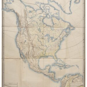
A detailed German map of North America providing the latest configuration of the American West.
Nord America mit Westindien.
$475
1 in stock
Description
This detailed map of North America was originally compiled by German mapmaker Heinrich Kiepert in the late 1850s and then updated by his colleague C. Gräf in 1862. It depicts the entirety of North America, stretching from Alaska, Greenland, and Iceland in the north across the United States, Mexico, and Central America to Columbia (Nueva Granada) and Venezuela in the south. The entire Caribbean is shown in similar high resolution.
The map was printed as a copperplate etching and then hand colored. The coloring follows formal borders, so each nuance defines a separate territory, country, or colony. The primary division is between the United States (bright yellow), Mexico (pink), and the countries of Central America (blue). Within the United States, the borders of individual states and territories are shown in the same yellow, albeit with a softer tone. Other colors throughout the map represent the colonial possessions of European nations, including Britain, France, Spain, Holland, and Denmark.
An important factor, and one of the main reasons that Kiepert’s maps of America continuously needed updating, was the rapid development of the western United States. New states and territories were being created at an impressive rate, and the Gold Rush had drawn innumerable new people to California.
In the Pacific Northwest, Alaska remains a Russian colony. The territory was sold to the United States in 1867. An inset map in the Pacific provides detailed renditions of the Aleutian Archipelago in the Bering Strait. Like Alaska itself, these islands would become US territory with the Alaska Purchase of 1867. Canada remains a full British colony at this stage. It was only with the British North America Act (now the Constitution Act) that Canada became a self-governing Dominion within the British Empire in 1867.
Cartographer(s):
The Geographical Institute of Weimar (German: Geographisches Institut Weimar) was a German map publisher. It was based in Weimar, Germany. The company was founded in 1804 and made globes, yearbooks, and maps. Friedrich Justin Bertuch managed the company upon its founding. Adam Christian Gaspari and Heinrich Kiepert worked there.
Heinrich KiepertHeinrich Kiepert (July 31, 1818 – April 21, 1899) was a distinguished German geographer and cartographer renowned for his detailed and accurate maps. Born in Berlin, Kiepert developed an early interest in classical studies and geography, studying at the University of Berlin under notable scholars such as Carl Ritter and Leopold von Ranke. His expertise in historical and regional geography and meticulous approach to cartography set him apart in the field. Kiepert’s early works included maps for historical atlases and travel guides, highly praised for their precision and clarity.
Throughout his career, Kiepert produced numerous influential maps and atlases, including his notable Atlas von Hellas und den hellenischen Kolonien (1846) and the Formae Orbis Antiqui (1893). These works were instrumental in studying ancient geography and were widely used in German educational institutions.
Condition Description
Very good. Folding map, dissected and laid on linen. Folds into original slip case.
References