Münster’s woodblock-printed map of North Africa, featuring a large Silphium region.
Aphricae Tabula III.
$475
1 in stock
Description
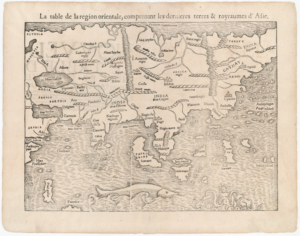
Sebastian Münster’s Aphricae Tabula III presents a Renaissance interpretation of the eastern reaches of North Africa, focusing primarily on the regions of Cyrenaica, Marmarica, and Egypt. Covering a broad swath of the Mediterranean coastline, the map stretches from modern-day Libya across the Nile Delta and into parts of the Red Sea basin. True to Ptolemaic convention, the map is oriented with east at the top, situating the viewer in an ancient worldview where the sun’s rising was metaphorically aligned with spiritual and geographical primacy.
Cartographic Features
The map employs a pictorial style typical of early 16th-century cartography, with mountains rendered as overlapping mounds, rivers as winding lines, and settlements depicted as stylized clusters. The Nile River, one of the map’s focal features, flows from the south (bottom of the map) toward the Mediterranean, coursing past classical sites such as Thebes, Memphis, and Alexandria. Inland regions feature numerous references to ancient and semi-legendary tribes, such as the Garamantes, Psylli, and Nasamones, underscoring the map’s classical roots. A boxed legend at the bottom left lists the principal cities of Marmarica, Egypt, and Cyrenaica, reinforcing the scholarly structure of the composition.
Mythological and Decorative Elements
At the top center of the map, within the Mediterranean Sea (Pelagus Aegyptiacum), Münster includes a reclining classical sea god. This mythological flourish reflects the mapmaker’s Renaissance humanism and taste for allegory. In the southwestern portion, the famed Silphionfera regio is depicted with abundant foliage, referencing the lost medicinal plant silphium once endemic to Cyrenaica. These decorative details serve both artistic and mnemonic functions, enlivening the landscape while highlighting the region’s rich classical lore.
Historical Context
Based on the writings of Claudius Ptolemy, Münster’s map reflects the enduring legacy of Greco-Roman geography into the 16th century. Though compiled at a time when more accurate geographic knowledge was becoming available, Münster adhered closely to classical sources, favoring Ptolemaic authority over modern exploration. This was in line with the aims of his Geographia and Cosmographia, which sought to revive ancient learning within a Christianized Renaissance worldview. His inclusion of ancient trade routes, place names, and tribal locations speaks to an intellectual agenda that fused geography, ethnography, and classical history.
Conclusion
Aphricae Tabula III is a visually compelling and historically significant example of early Renaissance cartography. Through its combination of classical names, speculative geography, and artistic embellishment, Münster’s map provides a rich window into how Europeans in the 16th century viewed and mythologized the northeastern regions of the African continent. It stands as both a pedagogical tool and a collector’s artifact, illustrating not only the places it depicts but also the intellectual landscape from which it emerged.
Cartographer(s):
Sebastian Münster (1488-1552) was a cosmographer and professor of Hebrew who taught at Tübingen, Heidelberg, and Basel. He settled in Basel in 1529 and died there, of the plague, in 1552. Münster was a networking specialist and stood at the center of a large network of scholars from whom he obtained geographic descriptions, maps, and directions.
As a young man, Münster joined the Franciscan order, in which he became a priest. He studied geography at Tübingen, graduating in 1518. Shortly thereafter, he moved to Basel for the first time, where he published a Hebrew grammar, one of the first books in Hebrew published in Germany. In 1521, Münster moved to Heidelberg, where he continued to publish Hebrew texts and the first German books in Aramaic. After converting to Protestantism in 1529, he took over the chair of Hebrew at Basel, where he published his main Hebrew work, a two-volume Old Testament with a Latin translation.
Münster published his first known map, a map of Germany, in 1525. Three years later, he released a treatise on sundials. But it would not be until 1540 that he published his first cartographic tour de force: the Geographia universalis vetus et nova, an updated edition of Ptolemy’s Geography. In addition to the Ptolemaic maps, Münster added 21 modern maps. Among Münster’s innovations was the inclusion of map for each continent, a concept that would influence Abraham Ortelius and other early atlas makers in the decades to come. The Geographia was reprinted in 1542, 1545, and 1552.
Münster’s masterpiece was nevertheless his Cosmographia universalis. First published in 1544, the book was reissued in at least 35 editions by 1628. It was the first German-language description of the world and contained 471 woodcuts and 26 maps over six volumes. The Cosmographia was widely used in the sixteenth and seventeenth centuries and many of its maps were adopted and modified over time, making Münster an influential cornerstone of geographical thought for generations.
Condition Description
Minor discoloration along the centerfold.
References