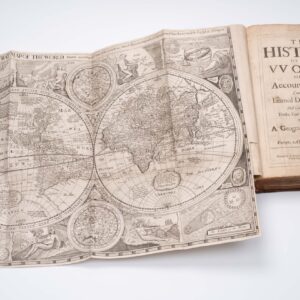
Elegant Hand-Drawn French Map of the World.
[Large French Manuscript World Map].
$1,800
1 in stock
Description
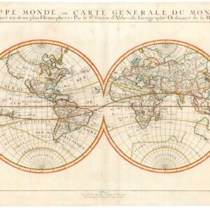
This is a stunning, richly decorated manuscript world map, annotated in French and enhanced with sailing-ship vignettes and elaborate ornamental borders. It is an elegant geographic representation imbued with abundant heraldic, nautical, and emblematic imagery. The map is laid out in a broad horizontal format and framed by an elaborate decorative border featuring coats of arms, fleur-de-lis motifs, and ornamental scrollwork.
The overall aesthetic deliberately evokes the visual language of early modern cartography, particularly that associated with the late sixteenth and seventeenth centuries. Yet the design also makes it clear that this particular map was produced much later, probably at the beginning of the 20th century.
The central field of the map depicts the known world, with Europe, Africa, Asia, and the Americas clearly delineated. Even though the projection approximates Mercator, it is more schematic and decorative, prioritizing legibility and visual completeness over geographic precision. Latitude and longitude lines are drawn across the surface, indicating a graticule-based mapping, yet the spacing and alignment are approximate. In the same way, continental outlines are simplified but clearly recognizable, with exaggerated coastlines and compressed interior spaces.
The Pacific Ocean occupies a large central portion of the map, visually balancing the Atlantic and reinforcing the image’s global scope. Oceans are labeled in French, including Océan Pacifique, Océan Atlantique, and Océan Indien. All the continents include thematic vignettes, with some regions being more densely labeled than others. Europe is one of the regions with a significant number of place names, including not only many capitals, but also key ports such as St. Malo, Marseille, Cadiz, Narvik, and Anvers (Antwerp).
Comparatively, Africa is depicted with more sparse interior detail, replacing topographic and toponymic details with three large vignettes. One of these, placed along the Guinea coast of West Africa, depicts a treasure chest, while another vignette shows a generic or imagined African tribesman. This imbalance in the map’s details reflects a common early modern cartographic practice in which less well-known regions were filled with symbolic or ethnographic imagery.
Asia is the only continental landmass that has been divided. While Western Asia stretches across the right half of the map, East Asia is shown along the map’s left edge. East Asia is another region on this map with more extensive labeling, reflecting French colonial interests. The selective labeling is also evident here, with Arctic islands and settlements prominently included.
The Americas are shown as two large landmasses connected by a narrow isthmus, with Panama taking pride of place. North America is labeled with familiar colonial-era toponyms. At the same time, South America includes the major cities along the Brazilian coast and a schematic representation of the Andes along the entire western edge of the continent. Throughout, mountain ranges are rendered schematically as rows of stylized triangles.
Nautical and ethnographic vignettes
Vignettes of five large sailing ships – rendered in a late Renaissance or early modern style, complete with billowing sails, rigging, and flags – dominate the oceanic spaces. Their composition and varying orientation create a sense of movement and give the map a distantly nautical or maritime feel. They also cast oceans as spaces of exploration, trade, and imperial ambition.
A large compass rose appears in the upper left quadrant of the map, decorated with alternating red, black, and cream points. At its center is a skull motif, an unusual and striking detail that may allude to the dangers of navigation, the memento mori tradition, or constitute a nostalgic reference to the age of pirates.
Scattered across the continents are human and animal figures. These include what appear to be hunters, explorers, frontier settlers, or ethnographic representations of indigenous peoples. The figures include an Inuit hunting a polar bear in Siberia, Native American tribesmen, and depictions of native peoples in Africa, Australia, and East Asia.
The already decorative map is enclosed within a wide, ornamental border. Along the left and right sides are repeated fleur-de-lis motifs, strongly associated with French royal symbolism. Set among these are larger heraldic shields, the meaning of which is unclear. At the top center of the map is another large heraldic emblem flanked by banners, further reinforcing the impression of royal or noble patronage. The border is not merely decorative but programmatic: it frames the world geographically while simultaneously asserting a political and cultural identity over it. The repeated fleur-de-lis, as well as the French toponymy, allude to royal authority or national pride, strongly suggesting an early 20th-century French origin for this map.
Context is Everything
This manuscript world map is best understood as a visual synthesis of geography, history, and symbolism. Its detailed decorative program, French language, and retrospective style point to a maker deeply engaged with the cartographic traditions of the early modern world, albeit one working later. Given the absence of a signature or date, any firm attribution must, however, remain tentative. The stylistic coherence and confident execution suggest a skilled draftsman familiar with both historical cartography and heraldic design. The map was likely produced by a trained artist or cartographer rather than an amateur. Hand-drawn retrospective maps of this kind were often created for display, education, or ceremonial purposes rather than for navigation. In France, such works could be commissioned by aristocratic patrons, educational institutions, or collectors interested in geography, history, or antiquarianism.
The use of French throughout the map points to a Francophone audience and maker. The emphasis on decorative elements (e.g. ships, figures, heraldry) over technical precision aligns with a tradition of cabinet- or presentation maps, which functioned as objects of learning and prestige. The form of retrospective revivalism is consistent with maps produced in the late nineteenth or early twentieth century, when historical styles were frequently emulated for pedagogical or decorative purposes. Manuscript world maps were sometimes created for classrooms, exhibitions, or as commissions for collectors fascinated by the Age of Discovery.
Cartographer(s):
Condition Description
Good.
References