1854 U.S. Coast Survey Reconnaissance from San Francisco to the Umpqua River.
U.S. Coast Survey — Reconnaissance of the Western Coast of the United States, Middle Sheet, From San Francisco to Umpouah River.
Out of stock
Description
Mapping America’s New Pacific Frontier
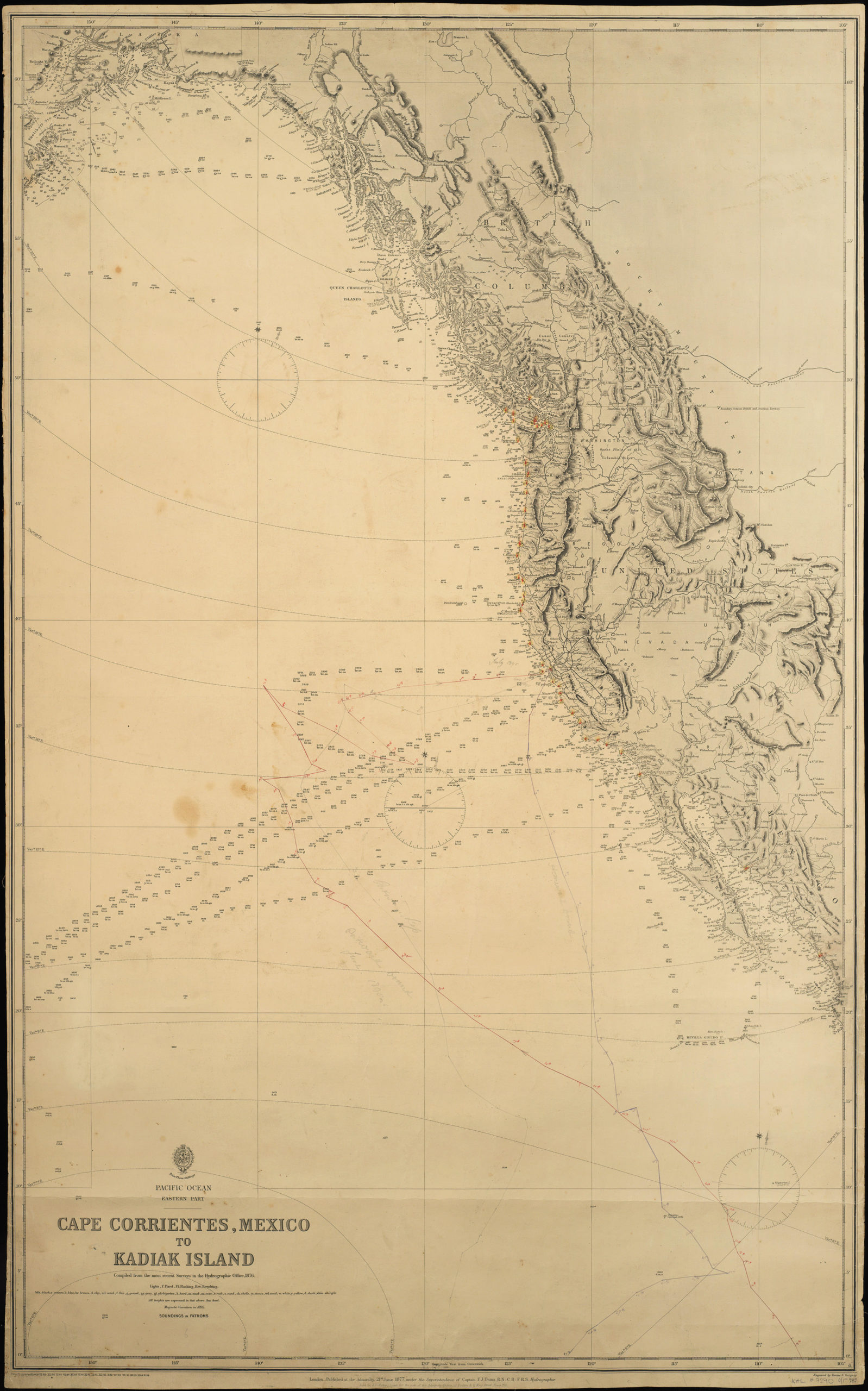
This is an 1854 U.S. Coast Survey Map of the Western Coast of the United States from San Francisco to the Umpqua River, issued under the superintendency of Alexander Dallas Bache and representing one of the earliest systematic hydrographic surveys of the American Pacific Coast. Published just five years after the California Gold Rush transformed San Francisco into one of the busiest ports in the world, it answered an urgent navigational need: the dramatic surge in maritime traffic along a coastline that remained, for most mariners, dangerously under-charted. This particular example has been enhanced with hand-colored coastal profiles.
The Map in Detail
Coverage runs along a narrow coastal strip from San Francisco Bay in the south to the Umpqua River in present-day Oregon, rendered with meticulous attention to soundings, anchorages, headlands, and hazards. The right-hand margin is occupied by a set of hand-colored coastal profiles — views of prominent landmarks as they appear from the sea at various bearings and distances — including Cape Arago, Cape Blanco, Trinidad Head, Humboldt Bay, and numerous other features critical to safe landfall. A large panoramic profile of the entrance to San Francisco Bay anchors the lower left. General sailing directions, tidal tables, and a register of latitudes and longitudes for key points along the coast complete the chart’s practical apparatus. Geographical positions were determined by G. Davidson, Assistant, and hydrography was conducted by the party under the command of Lieutenant James Alden, U.S.N.
Historical Context
Alexander Dallas Bache — great-grandson of Benjamin Franklin and one of the foremost scientists in antebellum American public life — transformed the U.S. Coast Survey into a scientific institution during his long superintendency from 1843 to 1867. The Pacific Coast surveys he oversaw in the early 1850s were among his most consequential achievements, responding directly to the explosion of maritime commerce that followed the Gold Rush. The two surveyors credited on this chart went on to distinguished careers: George Davidson became the preeminent authority on Pacific Coast geography, publishing his landmark directory of the coast; James Alden rose to the rank of rear admiral and commanded Union naval forces during the Civil War. Oregon, whose coast appears on the northern portion of this chart, would not achieve statehood until 1859 — this map thus depicts it as still a territory at the edge of the organized United States.
Publication History and Census
This chart is the middle sheet of a multi-sheet U.S. Coast Survey reconnaissance series covering the western coast of the United States, numbered No. 2 in the sequence. It was published in 1854 as an official government document, distributed to naval officers and commercial mariners navigating the Pacific Coast. Coast Survey charts from this period are held by major institutional collections, though hand-colored examples in good condition are less common in the private market.
Cartographer(s):
The Office of Coast Survey is the official chartmaker of the United States. Set up in 1807, it is one of the U.S. government’s oldest scientific organizations. In 1878 it was given the name of Coast and Geodetic Survey (C&GS). In 1970 it became part of the National Oceanic and Atmospheric Administration (NOAA).
The agency was established in 1807 when President Thomas Jefferson signed the document entitled “An act to provide for surveying the coasts of the United States.” While the bill’s objective was specific—to produce nautical charts—it reflected larger issues of concern to the new nation: national boundaries, commerce, and defense.
Alexander Dallas Bache, great-grandson of Benjamin Franklin, was the second Coast Survey superintendent. Bache was a physicist, scientist, and surveyor who established the first magnetic observatory and served as the first president of the National Academy of Sciences. Under Bache, Coast Survey quickly applied its resources to the Union cause during the Civil War. In addition to setting up additional lithographic presses to produce the thousands of charts required by the Navy and other vessels, Bache made a critical decision to send Coast Survey parties to work with blockading squadrons and armies in the field, producing hundreds of maps and charts.
In 1871, Congress officially expanded the Coast Survey’s responsibilities to include geodetic surveys in the interior of the country, and one of its first major projects in the interior was to survey the 39th Parallel across the entire country. Between 1874 and 1877, the Coast Survey employed the naturalist and author John Muir as a guide and artist during the survey of the 39th Parallel in the Great Basin of Nevada and Utah. To reflect its acquisition of the mission of surveying the U.S. interior and the growing role of geodesy in its operations, the U.S. Coast Survey was renamed the United States Coast and Geodetic Survey (USC&GS) in 1878.
Condition Description
Hand watercolor. Repairs along the left margin. Wear along fold lines, with minor loss.
References