1693 Nautical Chart of South Devon and Torbay, with Vignette of William of Orange’s Landing.
[Part of Devon Shire]
$550
1 in stock
Description
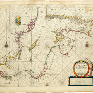
This nautical chart of South Devon and Torbay is among the most historically charged plates in Captain Greenville Collins’s Great Britain’s Coasting Pilot of 1693. Its cartouche, a gilded architectural frame attended by allegorical figures of Justitia and Prudentia enclosing a panoramic vignette of men-of-war at anchor in the bay, commemorates the landing of William of Orange at Torbay in November 1688, the pivotal event of the Glorious Revolution. Collins had been present at that moment, serving as master of HMS Resolution under Admiral George Legge, 1st Baron Dartmouth, the officer commanding the English fleet that was unable to prevent the landing. No plate in the atlas more directly encodes the political circumstances of its own production.
The Map in Detail
The chart covers the south Devon coastline from roughly Start Point in the southwest through the broad arc of Torbay and beyond. The harbors of Brixham, on the bay’s southern horn, and Torquay, on its northern side, are clearly delineated, along with the estuary mouths and coastal settlements of Dartmouth and the surrounding Devonshire shore. The bay is peppered with depth soundings, and rhumb lines radiate from two compass roses set in the open sea. The characteristic green wash of the land contrasts with the cream of the shallow inshore waters, producing a striking and legible composition. The large, magnificently ornamented cartouche in the upper right is the sheet’s dominant decorative feature: within a gilded architectural frame, attended by two allegorical female figures traditionally identified as Justitia and Prudentia, an oval vignette presents a panoramic view of Torbay crowded with men-of-war at anchor.
Historical Context
Collins noted in his sailing directions that Torbay offered large and clear ground for anchoring, particularly in westerly and southerly winds, and that the Royal Navy had ridden there in safety, a judgment confirmed by the bay’s repeated use as a fleet anchorage throughout the following century. Its strategic importance was most dramatically demonstrated on 5 November 1688, when William of Orange, leading a Dutch invasion fleet of some 500 vessels, anchored in the bay and came ashore at Brixham. The landing met no resistance and set in motion the sequence of events that would end with William and Mary on the English throne.
Collins had been directly implicated in those events. Serving as master of HMS Resolution, he was part of the English fleet under Admiral George Legge, 1st Baron Dartmouth, which had been dispatched to intercept William’s armada. Unfavorable winds (later celebrated in Whig tradition as the ‘Protestant Wind’) and hesitation in the fleet’s command prevented any engagement, and William’s landing proceeded unopposed. Collins’s chart, published only five years later and dedicated to a naval patron within a commemorative iconographic program, reflects the complex position of a professional naval hydrographer navigating the loyalties and realities of post-Revolution Britain.
Publication History and Census
This chart appears as a plate in Great Britain’s Coasting Pilot, first published in London in 1693. As is typical of the atlas, the geographic designation is embedded in the cartouche rather than presented as a formal title heading. The plates were reprinted throughout the eighteenth century by the Mount publishing dynasty, first as Mount & Page, later as Mount & Davidson, and surviving sheets are most often encountered as individual disbound leaves.
Cartographer(s):
Captain Greenville Collins (c. 1643–1694) was an English naval officer and pioneering hydrographer whose work laid the foundation for systematic coastal charting in Britain. Serving in the Royal Navy during the late seventeenth century, Collins gained practical experience in navigation and surveying at a time when reliable nautical charts of British waters were scarce. Recognizing the strategic and commercial importance of accurate maritime information, the English crown commissioned him in the early 1680s to conduct a detailed survey of the coasts of England and Wales.
Between roughly 1681 and 1688, Collins directed an extensive hydrographic survey of the English coastline, measuring depths, mapping shoals and sandbanks, and documenting harbors and navigational hazards. His work represented one of the first coordinated national charting efforts in England. The results were compiled into Great Britain’s Coasting Pilot, first published in 1693. The volume combined detailed engraved charts with sailing directions and coastal views, providing mariners with far more reliable guidance than previously available.
Collins’s atlas became the standard reference for navigation around British waters for decades and marked an important step in the professionalization of hydrography in England. His methods and charts influenced later surveying practices and helped improve maritime safety during a period of expanding naval power and overseas trade. Collins died in 1694, only a year after the publication of his landmark work, but his contributions established him as one of the earliest significant hydrographers of the British Isles.
Condition Description
Wear along the centerfold and margins. Image is nice.
References
Related products
-
-
Add to cart


- Europe, Italy, Bird's-eye-views
Venetia.
- $3,500
-
-
-
![[Map of Steamship Routes and the Railways and Post Roads of the Russian Empire]](https://neatlinemaps.com/wp-content/uploads/2020/04/NL-00827_Thumbnail-300x300.jpg)
![[Map of Steamship Routes and the Railways and Post Roads of the Russian Empire]](https://neatlinemaps.com/wp-content/uploads/2020/04/NL-00827-scaled.jpg)
![[Map of Steamship Routes and the Railways and Post Roads of the Russian Empire]](https://neatlinemaps.com/wp-content/uploads/2020/04/NL-00827-scaled-300x300.jpg)