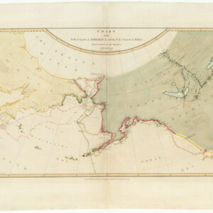
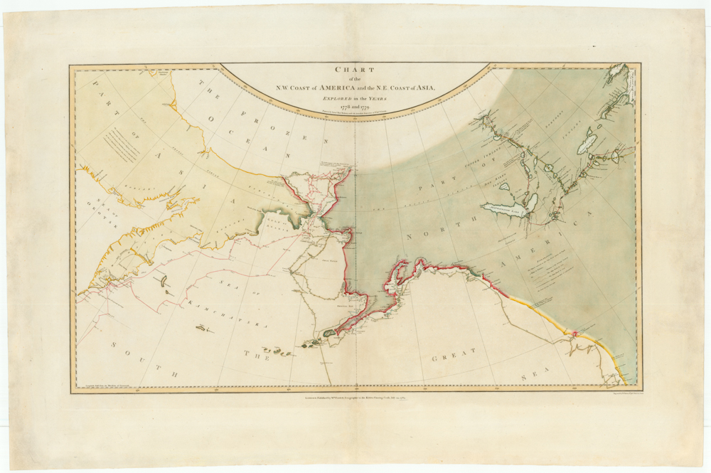
Famed North Pacific map, with a giant Sea of the West and the dubious discoveries of Admiral de Fonte.
Carte Des Nouvelles Decouvertes Au Nord de la Mer de Sud, Tant a l’Est de la Siberie et du Kamtchatcka, Qu’a l’Ouest de la Nouvelle France, Dressee sur les Memoires…1750
$1,800
1 in stock
Description
This Dezauche’s second state of Joseph-Nicolas Delisle’s 1750 map of the North Pacific, a massively important landmark map that sparked a decades-long cartographic debate. The mapmaker has employed a stereographic projection that incorporates the curvature of the the earth; it is this unique approach that allows the incorporation of a significant portion of Asia and all of North America, both of which “bend” away from the North Pole. In the upper corners we see two ovals framing indigenous figures — one a North American, the other a Kamchatkan — representing each side of the Bering Straight.
Delisle’s map featured an array of new information pertaining to the Americas, especially the Northwest Pacific, but it was extremely controversial in large part because Delisle compiled it primarily based on the quasi-mythological account of Admiral Bartolmeu De Fonte. In 1640, De Fonte supposedly sailed north from Lima (Peru) until somewhere around the 53rd parallel, where he entered a Rio de los Reyes. From here he was said to have navigated west through a series of waterways until he finally came upon a Bostonian merchant in what is presumed to have been the Hudson Bay. The historicity of De Fonte’s expedition is apocryphal at best, yet Delisle and Philipe Buache, and subsequently royal geographer Thomas Jefferys, depicted this geographical information as a ‘great probability.’
In addition to the disputed De Fonte transcontinental connection to Hudson’s Bay, the map features a wide array of cartographic myths, fantasies, and misconceptions. Its most prominent mythical element is undoubtedly the massive Sea of the West (Mer ou Baye de l’Ouest) in the Pacific Northwest above California, the origins of which are unknown, but which was at least partially related to the centuries-old ongoing search for a Northwest Passage.
Another interesting detail on the map is its extended depiction of Lousiane, which stretches from the Rio Grande into the Appalachian Mountains. This portrayal reminds us that all maps are political and this map was published in Paris by French mapmakers, who have sought to cement France’s territorial claims in North America.
States of the the Map
There are 2 states of the map:
1752: Buache imprint at bottom right
1780: Dezauche imprint at bottom right
Cartographer(s):
Joseph-Nicolas Delisle (4 April 1688 – 11 September 1768) was a French astronomer and cartographer.
Philippe BuachePhilippe Buache (born La Neuville-au-Pont, 7 February 1700; died Paris, 24 January 1773) was a French geographer, known for inventing a new system of geography and popularizing this field.
Buache was trained under the geographer Guillaume Delisle, whose daughter he married, and whom he succeeded in the Académie des sciences in 1730.
Buache was nominated first geographer of the king in 1729. He established the division of the world by seas and river systems. He believed in a southern continent, an hypothesis which was confirmed by later discoveries. In 1754, he published an “Atlas physique.”
The Dezauche FamilyJean-Claude Dezauche was a well-known Paris map publisher who set up his shop around 1770. The foundation for the business was his acquisition of the archives of Guillaume De l’Isle and Philipe Buache, two of the most highly-renowned royal French cartographers.
Among Dezauche’s many lucrative contracts was a monopoly on selling the maps produced by the national Dèpôt de la Marine. When his son, Jean André Dezauche, took over the family business upon his father’s death, he inherited this contract.
Condition Description
Original color. Some old stains and discoloration in the margins. Not a VG+, and priced accordingly; a great opportunity to own this map at a lower price. Map image very good.
References
Tooley, R.V. (Amer) p.35, #105; Wagner, H. (NW) 566; Schwartz & Ehrenberg p.161; Nebenzahl, K. (Silk Road) #5.5A. Warren Heckrote and Edward H. Dahl, "George le Rouge, Vitus Bering, and Admiral la Fonte: a Cautionary Tale about "Cartographic Firsts"" The Map Collector 64 (autumn 1993): 18-23. Lucie Lagarde, "Le Passage du Nord-Ouest et la Mer du l'Ouest dans la Cartographie Francaise du 18e Siecle," Imago Mundi 41 (1989): 19-43. Mary Sponberg Pedley, The Commerce of Cartography: Making and Marketing Maps in Eighteenth-Century France and England (Chicago: University of Chicago Press, 2005). H. R. Wagner, "Apocryphal Voyages to the Northwest Coast of America," Proceedings of the AAS XLI (1931): 179-234. Glyndwr Williams, “An eighteenth-century Spanish investigation into the apocryphal voyage of Admiral Fonte,” Pacific Historical Review 30, no. 4. (1961): 319-327.


![North Pacific Coast Hawaiian Islands South Coast of Oahu Pearl Harbor [Confidential].](https://neatlinemaps.com/wp-content/uploads/2026/04/NL-02556_thumbnail-300x300.jpg)