Among the finest railroad maps of America made in the 19th century.
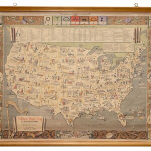
Watson’s New Rail Road and Distance Map of the United States and Canada.
$3,800
1 in stock
Description
Featuring a beautiful engraving of the locomotive ‘San Francisco.’

This striking map tells two intertwined stories: it celebrates the narrative of post-Civil War reunification and national unity while also embodying the transformative role of the steam engine in America’s history. Railroads were an essential, contemporary subject that resonated with Americans.
The main map depicts the railroad lines across the eastern half of the United States, extending westward to Nebraska, Kansas, and Texas. Compiled by Gaylord Watson, engraved by Fisk & Russell, and published in New York in 1869, the map was created to meet the growing demand for an up-to-date depiction of the American and Canadian railroad systems.
A Minimalist Yet Functional Design
Unlike Watson’s later maps from the mid-1870s, this map has a more diagrammatic style. It emphasizes the railroad systems while minimizing other cartographic details, limiting itself to plotting towns and cities, applying toponyms, outlining political boundaries, and color-coding states. The map aligns with international standards by including Greenwich as one of its prime meridians, but it also underscores its American origin by incorporating Washington, D.C., as a secondary meridian.
Interestingly, unlike some contemporary maps—which emphasized national reunification by showing the entire United States—Watson’s map excludes much of the western U.S. While the east and south coasts are shown in detail (with the notable omission of Florida), the western boundary is limited to Texas, Kansas, and Nebraska.
The transcontinental railroad is acknowledged on the map, but only in an elongated inset at the top. This inset illustrates the western routes of the Union Pacific Railroad, extending from Illinois and Missouri to California and the Pacific Ocean. Notably, it includes both the initial route completed in 1869 and the southern route, which would not be finished until 1883. The inclusion of the future southern route reflects the era’s optimism and forward-looking spirit, making it a natural addition to the map at the time.
East Coast Focus and the Westward Journey
The transcontinental railroad connected California and Nevada to the rest of the nation, linking pioneering Pacific cities like San Francisco and Astoria to the federal fold. The economic boom of the late 19th century owed much to the construction of western railroads, which traversed the Sierras and the Rockies’ formidable terrain. Despite these achievements, in 1869, many Americans—and cartographers—still regarded the West as peripheral to the nation. This “East Coast outlook” is evident in the map’s focus on eastern states and is reinforced by the inclusion of three detailed insets showing the railroad infrastructure around New York, Philadelphia, and Boston. These cities are symbolically elevated as the most important urban centers in the country, while the West is relegated to a secondary role.
This regional imbalance reflects Watson’s likely customer base. In the late 1860s, Americans and immigrants arriving from Europe were moving west in search of opportunity, freedom, and leisure. These individuals were the target audience for Watson’s map, not the relatively small number of Californians or Oregonians heading east. Watson’s business acumen is evident in the map’s front cover, which features a catalog of his previous maps, highlighting his marketing strategy.
Celebrating the Steam Engine
One of the map’s most prominent features is the engraving of the steam locomotive San Francisco, positioned below the three Atlantic insets. The steam engine, a symbol of 19th-century technological innovation and progress, plays a dual role in the map’s narrative. It sets the theme of the map while celebrating the steam engine’s role as a driver of mobility, trade, and prosperity. The choice of San Francisco as the locomotive’s name symbolically balances the map’s focus on the East Coast by acknowledging the significance of the West.
The map further underscores its railroad theme through extensive lists along its sides, detailing all railroad tracks in America, major stations, distances between them, and the costs of roads and equipment. With this wealth of information, travelers could plan their journeys across the United States with confidence.
Cartographer(s):
Gaylord Watson (1833 – 1896) was an American map publisher and engraver based in New York City.
Condition Description
Excellent condition. Backed on archival linen.
References
Modelski, Andrew. Railroad maps of the United States, 52 (1871 edition); Rumsey 3436 (1871 edition); Phillips p. 920.