A scarce map from the early days of the Gold Rush.
Map of the United States Mexico &c. Showing the various Land and Water Routes from the Atlantic Cities to California
$750
1 in stock
Description
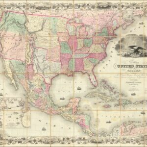
A remarkable map from the early days of the California Gold Rush, this is J. H. Colton’s 1849 map of the United States and Mexico, displaying the California gold region (somewhat north of its actual location) and routes between the eastern U.S. and California.
The routes of Frémont and Kearney, along with the ‘caravan route’ to Santa Fe and the ‘Oregon Route’ (Oregon Trail), are highlighted. Maritime routes around South America are demonstrated in an inset at bottom-left, a trip of 17,000 miles (or 5,900 miles if one dared crossing the Isthmus of Panama overland). A full table of distances along various routes appears to the right of the inset. Colton’s geography maintains the terminology of the period before the Mexican-American War (Upper California, for instance), while also hinting at the expansion of the United States along a pre-Gadsden Purchase border in the Southwest.
North and east of San Francisco, the former Russian trading post of Ft. Ross, John Sutter’s settlement of Nueva Helvetia, and Lake Tahoe (‘Mountain L.’) are labeled, along with the Sacramento River (exceptionally long here) and Feather River. Mountain passes and peaks are recorded with their elevations, along with settlements, forts, waterways, mines, Native American groups, and other features.
In sum, the map is an exemplar of early and somewhat inchoate attempts to map the Gold Rush, including the arduous task of actually reaching California, meeting the global demand for information on the momentous happenings in the hills east of San Francisco.
This map is based on Colton’s slightly larger ‘Map of the United States, the British provinces, Mexico &c.,’ a seminal map of the American West. The present work, which removed ‘British provinces’ from the title, appeared as a foldout map in at least two works, Emma Willard’s Last Leaves of American History: Comprising Histories of the Mexican War and California and, as with the present example, George Derby’s reprint of John C. Frémont’s The exploring expedition to the Rocky Mountains.
Cartographer(s):
George Horatio Derby, born at Dedham, Massachusetts, April 2, 1823, graduated from West Point in 1846, and after a tour of duty in the East and Middle West, came to California in 1849. He accompanied Brig Genl. Bennet Riley on a tour of the gold districts during the summer of that year, and his Sketch of General Riley’s Route was the result of that journey.
James AckermanJames Ackerman (1816 – 1864) was a lithographer and printer based in New York City. Among his cartographic productions were maps of the American West printed for the U.S. Government soon after the Mexican-American War.
Joseph Hutchins ColtonJoseph Hutchins Colton (July 5, 1800 – July 29, 1893), known professionally as J.H. Colton, founded an American mapmaking company which was an international leader in the map publishing industry between 1831 and 1890.
Condition Description
Professionally restored. Wear along original fold lines and in margins.
References