Rare 17th century portolan-style chart designed for use aboard Portuguese merchant vessels.
João Teixeira Cosmographo. De sua, Magestade. Aféz em Lixboa o Anno de 1649
$6,000
1 in stock
Description
An excellent issue of this rare and highly important map of the Indian Ocean, prepared by royal cosmographer to the Portuguese court, Joao Teixeira Albernaz the Elder (late 16th century – c. 1662), and published in Paris shortly after his death.
This map constitutes the best of contemporary knowledge and is a splendid example of the work and skill that went into producing navigational charts during the height of the Portuguese Golden Age. This document represents the transformation of extensive accumulated knowledge and effort into a powerful tool, a tool meant for dominion and profit.
When examining this particular chart, we are first struck by the fact that it essentially depicts an ocean. It is, in other words, a chart made for seafaring. In an age of territorial expansion and global trade, this is perhaps not surprising. Nevertheless, it is only with the surrounding coastlines that the map begins to take on actual meaning as a navigational and mercantile tool. The chart includes the east coast of Africa in its entirety; Arabia, including the Red Sea and the Persian Gulf in their full length; as well as the complete western seaboard of the Indian Subcontinent. All are depicted in great detail along the coast, but remain completely blank in the interior, once again underlining the chart’s raison d’etre.
A large number of islands in the Indian Ocean are depicted with their toponyms, including places like the Maldives, Reunion, Mauritius (I. de Diego Rodrigues), Zanzibar, the Comoro Islands, and of course a highly detailed Madagascar. In the north, the key island of Socotra is also depicted. All of these islands were important points of call on trans-oceanic journeys (for trade, supply, and navigational purposes), and their inclusion and careful positioning on the map reflects more than a century of active exploration and surveying.
Reliability was naturally a critical aspect of any good navigational chart, in particular when it came to depictions of coastal topography and infrastructure. Despite the geographic scope of this map, every anchorage, shoal, and safe harbor known at this point has been included, making its compilation a truly daunting task. In fact, even though the areas that were best known to the Portuguese for obvious reasons include many details, it does not seem that preference was given to any particular stretch of coastline on this map. We are in other words dealing with a highly versatile chart that would assist any navigator entering these waters.
The manner in which the ports are noted further confirms the functional nature of this chart. It was designed to be laid out on a table and spun to suit whatever stretch of coast one was navigating at the time. Consequently, the direction of writing in the place names changes as if one were sailing along the entire depicted coastline, from Comorin to the Cape of Good Hope. As Portuguese charts from this time were meant exclusively for Portuguese merchants, this versatility reflects a paucity of national monopolies on trade at this stage and is a window into a world that existed for less than a century.
Another important nautical feature on the map is the latitude staff that runs down its center. This ensured that one’s position almost always could be ascertained at sea using the navigational tools of the era (e.g. the compass, quadrant, and cross-staff), but it also served to visualize distances on the map. Extending from the staff, both the tropics of Cancer and of Capricorn, as well as the equator itself, are clearly marked on the map.
Even though the nautical nature of this chart meant that the interior regions were not annotated, a number of interesting regional names are nevertheless included. These demonstrate some of the vivid romantic fantasies that Europeans would entertain at the time. The Arabian Peninsula, for example, is simply referred to as Arabia Felix (Happy Arabia). This was originally a Greco-Roman term for the mythical lands from which incense derived (Yemen), but it had endured in the geographic understanding of the area until the age of exploration. Similarly, East Africa near the Horn is labeled Preste Joao, or Prester John; referring to a mythological Christian King in Africa.
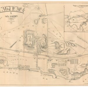
The chart has three inset plans of the fortified ports of Mobaca (Mombassa), Mosambique (Mozambique Island), and Sofala, as well as a detailed little map of Socotra. These were all major centers of Portuguese trade and important stopping points en route to India. While the first three constituted actual Portuguese colonies – the iconic outline of the Portuguese fort being present in all three insets – Socotra was no longer a Portuguese fiefdom.
Socotra had been invaded in the early 16th century and a fort was built shortly after. However, the settlement was abandoned after only four years and control was ceded to the local Mahra tribe. The island nevertheless remained an important port of trade and the gateway for sought-after goods from Arabia, in particular frankincense, myrrh, and spices. Ships would sail around the island and approach it from the north, where two large bays served as open anchorages for merchant vessels. Naturally, these have been noted on the map. Also included on the map was an area of freshwater springs. In one of the most arid climates on the globe, re-stocking water supplies would have been a constant concern of any captain.
This particular issue of the map shows both the ancient Arab-Sudanese emporium of Suakin (Suaquem), as well as the ancient Swahili port of Melinde. It was Vasco da Gama who first visited Melinde in 1498, while en route to India. Within two years Melinde was formally recognized as a Portuguese vassal and quickly became the most important Portuguese hub on the East African coast. Melinde’s role in Portugal’s trade empire continued for almost a century until the Portuguese moved their seat of operations to Mombassa in 1593. This deliberate shift sent Melinde into a spiral of decline so devastating that only a few decades later, it was not even deemed worthy to be included on this otherwise comprehensive chart.
Context is everything
Despite its vastness, The Indian Ocean has never set people apart. On the contrary, it bound them together. Some of the earliest known cultures traveled and traded along its rim, and grew into great civilizations doing so (e.g. the Sumerians or Harappans). For centuries, trade followed the coastline. But sometime in the 1st millennium BCE, Indian seafarers discovered that they could use the seasonal monsoon winds as carriers across the open sea. This revolutionized mobility and long-distance trade, which soon became the subject of cultural dominance. By Roman times, Asian merchandise had become such an important fixture of high society, that the so-called ‘Silk Road’, a land-based trade network stretching across Eurasia, had an equally lucrative maritime counterpart. In fact, in the 1st century CE, it would not have been an unusual sight to a hundred Roman ships anchored in great Indian ports such as Muziris or Arikamedu, waiting for the monsoon winds to carry them home.
When the Portuguese entered these waters in the late 15th century, the region had been booming with intercontinental and intercultural trade for centuries. The process by which the Portuguese gradually came to dominate these waters is closely tied to their methodic approach, though gunpowder and galleons played their role as well. After Vasco da Gama’s circumnavigation of Africa in 1498, the Indian Ocean was opened to the Portuguese, who by any measurement made the most of the new opportunities afforded them. Endless expeditions were mounted and immense records of everything worthy of note were kept, from safe coves and friendly natives to priceless resources, political structures, and military capacities.
Shortly after da Gama’s successful voyage, the Portuguese crown established a number of institutions designed to develop, regulate and monopolize trade with the East. The Casa da India, for example – the institution that Teixeira served for most of his professional life – was set up as early as 1500. Every year, the crown would organize large fleets of Portuguese traders – the so-called India Armadas – to sail jointly on the eastern colonies (especially Goa). For the first half-century or so, these ships were under the direct charge of the crown and traded exclusively for the King of Portugal, but over time this changed.
Controlling the nautical routes between the Cape of Good Hope, Arabia, and the west coast of India, not only ensured huge profits but also cemented Portugal’s political power vis-à-vis Spain and other European courts. The island of Java had been under Portuguese control since the early 16th century when the Portuguese seized it to secure the lucrative spice trade. During the 16th and 17th centuries, the Portuguese constructed fortified colonial settlements all around the Indian Ocean, including in Eastern and Southern Africa, on the Arabian Peninsula, and on the Indian Subcontinent. Trade colonies and fortified emporia were built so ubiquitously that to this day, remnants of the characteristic star-shaped Portuguese forts can be found everywhere from Ghana to Goa; from Bahrain to Brazil.
Despite efforts to monopolize trade and maximize gain, by 1570 the Casa da India was in such financial difficulties that King Sebastian opened up the trade to private Portuguese merchants as well. Only a decade later, the Portuguese crown was subsumed under the Spanish King Phillip II in what came to be known as ‘The Iberian Union. This meant that the divergent colonial interests of the two kingdoms had to be aligned, and gradually focus was shifted from the Indies to the New World, where Spain had laid claim to vast territories. Slowly but surely Portuguese control of the region dwindled.
Indeed, the Portuguese were not the only seafaring nations interested in securing lucrative trade routes with the East. During the 17th century, the Dutch and English would become major players in the arena of exploration and trade as well, usurping lands and routes initially engaged by the Portuguese. The process was gradual, but by the dawn of the 18th century, Portugal no longer played a significant role in the India Trade. The Americas had become the big prize and Portuguese interests in Brazil were given ever-greater priority from the mid 17th century onward.
Cartographer(s):
Joao Teixeira Albernaz I/the Elder (late 16th century – c.1662) spent his life in service of the Portuguese crown, the naval super power of the age. He was one of the most accomplished and prolific mapmakers of the 17th century. As part of a long line of cartographers that supplied the Portuguese court with charts from the mid 16th century until the late 18th century, Teixeira was initiated in the art of mapmaking by his father, Luis Teixeira, who himself was a renowned cartographer (e.g. he contributed one of the earliest maps of Japan to Abraham Ortellius’ famous atlas Theatrum Orbis Terrarum).
The young Joao would soon enter into formal apprenticeships with the finest cartographic institutions, and in 1602 he was examined by the Royal Cosmographer Joao Batista Lavanha, attaining the formal title of ‘Master of nautical charts, astrolabes, compass needles and cross staff’. Three years later, he was appointed cartographer to the Casa da India (India House); a state-run organization that regulated international trade and administered the Portuguese colonies.
Joao worked closely together with his brother Pedro Teixeira for extended periods, including at the Spanish court in Madrid. Among the famous maps they produced together was a detailed chart of The Straits of Magellan from 1621. Joao Teixeira nevertheless focused most of his efforts on regions in which Portugal had direct political or mercantile interests. And so, areas such as Brazil and Indonesia stand out in his oeuvre. But in many ways these two colonies lay at either end of the axis of Portuguese interests, as this chart amply demonstrates.
Joao Teixeira was indubitably one of the most talented and productive Portuguese mapmakers of the 17th century. During his career, he produced at least 215 charts, many of which were compiled into exquisite atlases. His patrons were the elites of society, usually the royal courts of Portugal and Spain, but his work is far more than artistic rendition.
Joao Teixeira Albernaz and his family operated at a pivotal time in history. The bold drive into the unknown that characterized the 16th and 17th centuries, produced a prodigious wealth of new information on the world, and nowhere did this crystalize more clearly than in the cartographic visualizations of the age.
Melchisedec ThevenotMelchisédec Thévenot (1620-1692) was a French scientist, author, cartographer, traveller, inventor and diplomat. A true polymath, Thévenot has been attributed as diverse accomplishments as the invention of the bubble level and the promulgation of the breaststroke in swimming. He served the French King as Royal Librarian and later as the French ambassador to Italy. In addition to his mother tongue, he supposedly spoke six or seven languages fluently, including Oriental languages such as Hebrew, Arabic and Turkish. His family background was Huguenot (French protestants), but Thëvenot was a true renaissance man, corresponding fervently with the great minds of the age, including the Dutch physicist Christiaan Huygens and the Florentine mathematician Vincenzo Viviani.
Thévenot became interested in cartography as part of his work on the book Relation du Divers Voyages Curieux, which was published in Paris in 1663. In it, he used his extensive knowledge of oriental languages to translate and summarize ancient manuscripts pertaining to voyages of exploration and discovery. Among these was the first European translation of Cosmas Indicopleustes, the travelogue of a 6th century Christian missionary to India (although the India referred to in his book most likely is Ethiopia). To this day, Indicopleustes is one of the most important sources we have on Late Antique trade with the East.
Thévenot’s cartographic claim to fame came from his mapping of Hollandia Nova (greater Australia), in which he physically separated it from Terre Australe. This division, emphasized by a meridian staff on the map, was not only geographically innovative, but served as a demarcation for Spain’s claims to the Pacific, lending a clear political dimension to the map as well. While there was some discussion as to how and how much Thévenot’s map differed from the more famous map by Johan Blaue, it cemented his name in cartographic circles. Consequently, when Emmanuel Bowen published his famous Complete System of Geography in 1747, it included Thévenot’s map.
Condition Description
Very good. Folds as issued, some repairs.
References