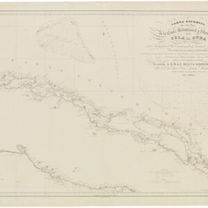
Excellent Spanish sea chart of Western Cuba.
Carta Esferica De Una Parte de la Costa Setentrional y Meridional de la Isla de Cuba…
$450
1 in stock
Description
Early‑modern nautical science and the unabated global ambitions of the Spanish crown.
The Carta Esférica de una parte […] de la Isla de Cuba is a masterfully engraved nautical chart originally produced in 1837 by Spain’s Dirección Hidrográfica in Madrid. It was reissued in its current format in 1867, following some critical corrections around Havana made in 1864. The map was executed on a spherical projection using the Cádiz meridian. The sheet measures 86.5 × 60 cm and is drawn at a standardised scale using Spanish marine leagues (Leguas Marinas de España), corresponding to about 1:544 700. It stretches from Punta Icacos and Cayo de Piedras in the east to Cabo San Antonio in the west, encompassing both the northern and southern coasts of Cuba, the Isle of Pines (today’s Isla de la Juventud), and nearby keys such as Cayo Largo and Cayo Blanco.
Surveys of the north coast were conducted under the orders of Brigadier Ángel Laborde y Navarro, the Commander of the Havana naval station, using the schooners Ligera and Habanera. Their crews logged numerous depth soundings (brazas), charted reefs and shoal positions, noted the force and direction of currents, and sketched shoreline profiles. The southern coast was mapped more eclectically using data from earlier records and naval reconnaissances. In Madrid, naval draftsman Miguel Moreno converted these raw observations into finely detailed coastal outlines. At the same time, engraver Rafael Esteve incised the plate, and C. Marquerie lettered the titular calligraphy and various legends.
Visually, the map eschews decorative flourishes to focus on hydrographic utility. Its sinuous coastline has fine hachures, indicating low cliffs and beach gradients. Shoals and reefs are clustered and named, especially around the western entrance to the Havana Channel. Depth soundings and notes on the currents guided mariners through prevailing flows, especially off Cuba’s western Cape San Antonio. The chart is void of pictorial vignettes or inset plans, affirming its explicit purpose as a navigational tool.
In the early 1830s, Cuba was Spain’s wealthiest overseas territory. Its sugar and tobacco plantations, fuelled by the slave trade, underpinned Spain’s metropolitan economy. Havana was both a fortress protecting trans‑Atlantic convoys and a bustling mercantile hub. Precise charts were indispensable for naval squadrons defending colonial ports, merchant ships navigating treacherous banks, and customs pilots enforcing imperial regulations. By providing a standardized network of rhumb lines, soundings, and hazard symbols, the charts of the Dirección Hidrográfica helped reduce shipwrecks, curtailed smuggling, and streamlined naval operations in the Caribbean.
This chart belongs to the second generation of Cartas Esféricas issued between 1834 and 1837. Born from the Depósito Hidrográfico (established 1797), the Dirección Hidrográfica centralized Spain’s chart‑making by standardizing projections, scales, meridians, and rhumb‐line networks; archiving antiquated plates to understand the development of knowledge; and maintaining standing brigades of surveyors to enhance or correct the Dirección’s cartographic output. By the mid‑19th century, the Dirección’s products covered most of Europe’s coasts, Spain’s colonies, and all the major global sea lanes.
The 1837 Cartas Esférica of western Cuba exemplifies the institution’s aim to professionalize naval cartography. In general, the Dirección’s charts represent Imperial Spain’s maritime reach. In contrast, in this particular case, the chart also constitutes an invaluable record of Cuba’s pre‑industrial shoreline, just before steam power and modern dredging would completely reshape its harbors.
Cartographer(s):
The Direccion Hidrografica de Madrid was an official institution established in Spain in 1797. It was charged with surveying and publishing important charts and maps from all over the world and became known for the quality of its execution and accuracy.
From its origins in the late 18th century as the Depósito Hidrográfico (1797), the institution that became the Dirección Hidrográfica centralized Spain’s naval cartography under royal patronage. Establishing dedicated surveying brigades, chart engraving workshops, and archival stores in Madrid transformed disparate coastal reconnaissances into a coherent national catalogue of “spherical charts.” These were designed to a uniform standard: using the prime meridian at Cádiz; scaling in Spanish nautical leagues, conforming projections, and systematising rhumb lines and sounding patterns.
In the first half of the 19th century, the Dirección Hidrográfica expanded its reach to Spain’s overseas domains. Drawing on commanders like Ángel Laborde in Havana or Cosme Churruca in the Antilles, it produced dozens of detailed charts covering the Gulf of Mexico, the Caribbean islands, West Africa, and the Philippines. The 1837 chart of Cuba’s northern and southern shores exemplifies their refined methodology: combining fresh hydrographic surveys with existing data, then entrusting the final composition to skilled delineators and engravers in Madrid. These charts underpinned Spain’s maritime operations and stand as enduring records of early‑modern nautical science and the continued global ambitions of the Spanish crown.
Condition Description
Laid on contemporary linen with some wear and minor blemishes. Very good.
References