One of the earliest obtainable maps on the open market to name ‘America.’
Orbis Typus Universalis Iuxta Hydrographorum Traditionem Exactissime Depicta 1522 L.F.
Out of stock
Description
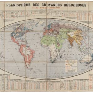
Orbis Typus Universalis is a milestone in any serious map collection dealing with the 16th century, for it is among the earliest obtainable maps that name ‘America.’ Printed as a woodblock engraving for the third, Servetus Edition of Laurent Fries’ adaptation of Martin Waldseemüller’s Ptolemaic atlas, this particular map was one of three entirely new maps that Fries added to Waldseemüller’s spread. Fries had compiled it by drawing on Waldseemüller’s cartographic work, in particular his two famous maps: Universalis Cosmographia (1507) and Tabula Terra Nove (the so-called ‘Admiral’s Map’ —1513). Even though our version of this map comes from the third edition of Fries’ atlas, it is important to note that no changes were made to the maps in the first three editions, but only to the accompanying texts on the verso. Consequently, we are dealing with an original map created by Fries in the early 1520’s that draws directly on even earlier sources.
Fries was undoubtedly aware of the importance of this new map, for he makes a point of including his initials in the titlebar above the map. The same bar also carries the date 1522, which marks the publication of the first edition of this atlas. Unlike the two other world maps in that book, this map carries a number of maritime hallmarks, the most important of which is the basic rhumbline network anchored in a set of simple roses. These directional lines were becoming ever more crucial for navigation, especially after the effects of magnetic declination had become more pronounced in crossing the Atlantic. With the upper border of the map being used for the title date and initials of the mapmaker, the left and lower borders have been converted into an early form of latitudinal and longitudinal demarcation.
Cutting across the entirety of the map are four thick lines denoting the tropics of Cancer and Capricorn, the Equator, and the Arctic Circle. This allowed Fries’ map to be cross-referenced with other large scale maps of the period. Framing the map itself is a peculiar set of banners bound together by ropes and equipped with the names of winds; a crucial element for any sailor. In unison, the nautical features set this map apart from the rest of the atlas and both subsequent cartographers and scholarship have seen a clear link between this chart and Waldseemüller’s Admiral’s Map, which essentially shows the Atlantic crossing (1513). However, considering the limited applicability of the map in navigational terms, it can hardly be classified as a sea chart in the traditional sense. Even so, many continue to see it as such.
While obviously the least detailed component of the map itself, by far the most important is the extremely early depiction of the Americas; more specifically the Caribbean Archipelago and South America, for there is no trace of a northern continent. A total of six toponyms are provided for the New World, the largest of which denotes the great southern continent and reads ‘America.’ This is essentially what makes Fries’ map so special, for other than Waldseemüller’s Cosmographia, it was the first published map to do so.

In addition to this fateful designation, we find three more localized toponyms in the form of ‘Batoia,’ ‘Cambales,’ and ‘Caput Sacre.’ Further north, in the Caribbean, the two large islands have been labeled ‘Spagnola’ and ‘Isabella‘ respectively, just as it was done on the Admiral’s Map. Not much else is shown, although we might note the impressively accurate approximation of South America’s general outline — especially in light of the fact that this map was first published just months before Sebastian Cano and the Magellan expedition returned from the first circumnavigation of the globe. A final note should be made on the large sea-bird just off the tip of the continent, which is the only obviously living creature shown in the map.
Casting our attention to the Old World, there are a number of both classic and highly innovative features worth noting. Greenland maintains its strange elongated shape, hovering over Scandinavia, and clearly constituting an early amalgamation of whalers’ reports from Greenland and Spitsbergen. Below it, most of Europe retains a familiar shape and with expected toponyms, although Italy seems to have been cut a bit short, perhaps as a result of the growing competition with Italian cartographers. Moving out into the North Sea, we find a strange configuration of four islands, all roughly of the same proportions. The labels inform us that these are Iceland, Scotland, England, and Ireland respectively. In light of the map’s scale and age, a degree of warping and misplacement is perhaps to be expected, but the rendition of Scotland and England as physically separated by water is an idea that goes all the way back to Antiquity, and which was no longer seriously entertained in 16th century Europe.
There are other clear elements of the Ptolemaic world view in play in the rest of the map as well. A well-known and ancient misconception that was carried well into 18th century mapping, was the notion of the Mountains of the Moon (Mons Lunes) in the heart of Africa. From here, melting waters flowed into two great lakes, which formed the mystical source for the living-giving Nile River. Moving east, the Red Sea has been squeezed in favor of the Persian Gulf, which is depicted as much larger than in reality. And in the Indian Ocean, we find Madagascar as a huge island in the middle of the ocean and seemingly associated with another enormous island labeled ‘Iava maior.’ India is more aptly shaped, but disproportionately large compared to the rest of the map. And finally furthest to the east, we find another ancient conceptualization in the enormous Malay promontory, also known as ‘The Dragon’s Tail.’
Like America, the other continents are also named correctly: Africa, Europa, Asia, and Tartaria (Russia). Other interesting toponyms include Cathaio (China), Arabia Felix, and the ancient kingdoms of Saba and Sogdiana.
Context is everything
The current map was drawn by the French cartographer Laurent Fries (Laurentius Frisius), a Rhinelander born in Mulhouse in eastern Burgundy, close to the German and Swiss borders. As a young man, Fries studied medicine and mathematics at the universities of Vienna, Montpellier, Padua and Colmar, before settling in Strasbourg around 1518 with the ambition of becoming a physician and medical publisher.
In the following years, he gained employment as a draughtsman working for Peter Apian on his extraordinary heart-shaped map of world (published in 1520). As part of this work, Fries carefully studied the maps of local master cartographer Martin Waldseemüller, who had published his most seminal world map as early as 1507, and had subsequently complimented this achievement with a major Ptolemaic-style atlas issued in 1513 (and revised in 1520). Fries’ fascination with Waldseemüller’s maps brought him into contact with the German printer and publisher, Johannes Grüninger. This was an important turning point — for Grüninger was the formal publisher of a group of local scholars known as the St Die Gruppe, which counted prominent members such Walter Lud, Martin Ringmann and not least, Martin Waldseemüller.
Strasbourg was famous as a center for cartography at this time, being home to two of the world’s best mapmakers: Martin Waldseemüller and Peter Apian. The two set new standards for the compilation of maps and charts, but Waldseemüller in particular revolutionized the way in which the world was rendered. In was Waldseemüller’s hugely influential world map from 1507 that would apply the term ‘AMERICA’ for the first time. In an associated text, he explained that the origin of the name pertains to the explorations of Amerigo Vespucci. This was a controversial claim at the time, and one that is still debated by cartographic scholars to this day. The important thing to note here is that when Waldseemüller issued his version of Claudius Ptolemy’s Geographia in 1513, he chose to change this label back to ‘Terra Incognita.’ Despite this semi-retraction, the impact of his world map was so profound that the name stuck in perpetuity.
Martin Waldseemüller died in 1520. His death was not only a great loss to mapmaking, but also to local publishing houses, and indeed to Strasbourg itself, as his output had become an important source of both income and prestige. Consequently, it was quickly decided to reissue the Waldseemüller atlas in a new edition in the hope that it would sustain both interest and income for a time. Grüninger got his hands on the 1520 edition and was keenly interested in filling the gap produced by Waldseemüller’s death. An agreement was reached among several local publishers that a revised and compacted version of Waldseemüller’s monumental tome was in order, and it was Laurent Fries who was hired as the cartographic editor-in-chief for this project. The basis for this decision should probably be sought in his knowledge of Waldseemüller’s work and his close professional association with Peter Apian. Fries actually started his independent cartographic career by re-drawing Waldseemüller’s famous world map and publishing it in reduced form in Caius Julius Solinus’ Enarrationes, which was published in Vienna that same year.
Even though Fries was not a geographer by training, from his time working for Apian he understood many of the mechanisms and skills behind compiling convincing and impacting maps. Under Fries’ direction many of Waldseemüller’s maps were now re-sized and redrawn. While the maps themselves remained largely unchanged in most respects, Fries would often add text such as historical notes and legends, or embolden the map with illustrations of prominent political or mythological figures, as well as a bestiary of both land and sea creatures. Since the aim was to compile a more compact version of the atlas, Fries also introduced the idea of printing text on the verso of the maps, and not on separate sheets like Waldseemüller had done. Finally, Fries included three entirely new maps in his atlas, which depicted South-East Asia and the East Indies, China, and the World respectively. While these were not taken from the 1513 atlas, the geographic information was adapted more or less directly from Waldseemüller’s Universalis Cosmographia, stressing just how seminal he remained even after death.
Chronology of the Fries’ Editions
Fries’ atlas never became the huge commercial success it was intended to be. Despite having both a more portable format and a more affordable price than Waldseemüller’s original, troubles with distribution and growing competition made sales of the initial edition an uphill battle. There was a widespread idea that the Fries atlas was privileged with better and more up-to-date geographical knowledge, but this was hardly the case, as Fries built his maps almost exclusively on Waldseemüller’s originals.
Notwithstanding the first edition’s lack of popularity, four distinct and formal editions of the Fries atlas were issued over the next twenty years. The first original atlas was published in Strasbourg itself in 1522, only two years after Waldseemüller’s death and the publication of the final edition of his Ptolemaic atlas. The first Fries edition consisted of fifty woodcut maps, including one of the earliest known maps to label the New World as ‘America.’ While this was copied directly from Waldseemüller’s Universalis Cosmographia, the tight chronology of these editions and the unavailability of Universalis Cosmographia on the market, meant that the Fries editions constitute the the earliest acquirable maps to name America. It has been estimated that circa 1000 copies of Waldseemüller’s map 1507 map were issued. Of these, only one known copy survives. This was discovered by Josef Fischer in 1901 in the attic of Wolfegg Castle in southern Germany and was purchased by the Library of Congress a hundred years after.
Despite its ambitions and success of its precursor, Fries’ first edition of the atlas was not a huge commercial success and the circle of responsible publishers soon felt a need for critical amendments. Thus, only three years after the initial publication of the atlas (1525), a new edition was issued. This contained an entirely new text by Wilibald Pirkheimer (adapted from Johannes Regiomontanus), but the exact same maps as the first version.
In 1531, Grüninger died and his publishing house was carried on by his son. Many of the printing plates owned by Grüninger were sold to other publishers in order to keep the business afloat. The materials for the Fries atlas ended up with two brothers in Lyon, Melchior and Gaspar Trechsel. They issued a new edition in 1535, this time with a freshly revised text written by the radical physician and free-thinker Michael Servetus. Consequently, the maps from this publication have become known as the Servetus Edition.
Despite the maps themselves undergoing very little change, this version of the Fries atlas is surrounded with some drama, as Servetus was tried as a heretic and burned at the stake following its publication. His crime, supposedly, were the following derogatory comments made about the Holy Land in the verso text of the Holy Land map. Roughly translated it reads:
“And so, most excellent reader, you should realize that in error and by pure exaggeration, a reputation for excellence was bestowed on this land; however, the testimony of merchants and travelers detracted from this inhospitable and barren land, which lacks any attraction, any reputation for excellence. Therefore, this so-called promised land should not be praised in a vernacular language.”
There is no doubt that Servetus was a man of the Enlightenment, and as such had been a vociferous critic of the religious establishment — in particular of Calvin himself — for decades prior to being persecuted for this particular crime. Ironically, however, the comments in question were not part of Servetus’ new text. Rather, they were elements copied from the original Strasbourg editions. Yet Servetus had made powerful enemies, and had even managed to escape an arranged Inquisition trial once before. So when Servetus confronted Calvin in person during a sermon in Geneva, he was quickly arrested and put on trial once more.
During his trial, the fact that the comments were not his, but simply adapted from the earlier editions, were stressed emphatically, but did nothing to sway the prosecutors and judges. On October 27th 1553, Michael Servetus was burned at the stake for blasphemy. He suffered a final denigration in discovering that the pyre upon which he would burn was composed in part of his own books, manuscripts, and maps. It is for this same reason that the maps from the Servetus Edition are so rare on the market.
Even though apostasy and descent generally were met with mercilessness from all branches of the Church, Servetus had in his youth published extensive critiques of both church and gospel, eventually landing him such powerful enemies that he was forced to flee to Paris. The fact that he was only caught in the end as a result of traveling to Geneva to fulminate against his powerful arch-enemy in person, shows a degree of fanatic recklessness. Nevertheless, the brutal persecution of a man of knowledge and letters sent shockwaves throughout the cartographic communities of Europe. The 16th century was an age of exploration and experimentation, but clearly new horizons for knowledge could not be sought without some backlash. Consequently, when Gaspar Trechsel funded the fourth and final version of Fries’ atlas, published in Vienne in 1541 (i.e. twelve years before Servetus was sentenced to death), the new editor, Dauphiné, made sure that the controversial comments were stricken.
In sum, the trajectory along which 16th century cartography evolved meant that Waldseemüller in many ways remained the great pioneer in mapping the Americas. This was no doubt because of his brilliance as a cartographer, but most of all because his Universalis Cosmographia became the chart that ultimately gave America her name. And yet the extraordinary rarity of Waldseemüller’s 1507 map, along with his decision to remove the America label from the continent in his 1513/1520 atlas, meant that the Fries edition of Waldseemüller’s maps constitutes the earliest obtainable copy of a map to actually name America. Among the four Fries editions, in which the maps themselves actually undergo very few changes, it is the original 1522 and the Servetus editions which are the rarest. Moreover, due to the dramatic ‘Enlightenment struggle’ story associated with the third edition, it has also become a symbol of the Enlightenment’s resistance to the Church’s brutal insistence on popular ignorance.
Cartographer(s):
Laurent/Lorenz Fries (ca. 1485-1532) was born in Alsace circa 1490 and studied medicine and mathematics at a number of European universities. He was trained as a physician but was also keenly interested in cartography and medical publications. From 1518-19 Fries is mainly based in Strasbourg, where he was commissioned to compile the first edition of Waldseemüller’s atlas after his death in 1520.
Condition Description
Wear along the centerfold.
References

![[Ortelius & Hogenberg Atlas Factice]](https://neatlinemaps.com/wp-content/uploads/2023/03/NL-01678-leo-belgicus-3_thumbnail-300x300.jpg)