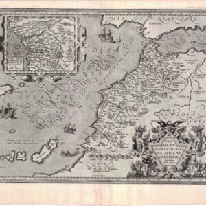
Late 17th century Jaillot map of Africa
L’Afrique Divisee Suivant l’Estendue de Ses Principales Parties ou sont Distingues les uns des Autres…
Out of stock
Description
Pierre Mortier’s publication of Jaillot’s revised version of Sanson’s 1668 map of Africa. This issue undated, with Mortier’s imprint in the scale.
The map presents the standard depiction of the source of the Nile based on Ptolemy. However, Jaillot introduced a new depiction of the rivers south of the Ptolemaic lakes. The Zambeze River appears above the Zambere and Rio de Spiritu Santo, all of which flow into the Indian Ocean.
A large section of South America is shown and two St. Helena islands appear – a common error in maps from this period.
The large distance scale cartouche has six scales. The decorative title cartouche, also copied from Jaillot, includes a tumult of figures, cornucopias, an elephant, crocodile, lion and ostrich, all under the coat of arms of the Dauphin.
Cartographer(s):
Pierre Mortier the Elder (1661-1711) was a French cartographer and publisher who, in 1690, obtained the French king’s privilege to distribute the works of French geographers – particularly Hubert Jaillot – in the Netherlands. He subsequently settled in Amsterdam and built an extensive business on reissuing French maps. His son would take over his father’s business and become the latter half of the mapmaking duo Covens & Mortier.
Condition Description
Some minor soiling, wear along centerfold with paper repair on verso.
References