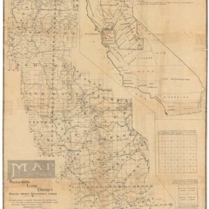
Excellent 1914 C.F. Weber map of Marin County
[Marin County]
Out of stock
Description
This is a simple and elegant map of Marin County produced from the drafting skills, survey work, and confirmation studies of John and Ernest Punnett, who were known as successful producers of highly accurate and confirmed title and cadastral maps for professional uses by title companies and subsequent publishers like C.F. Weber & C, Charles F. Metskers, and Edward Denny & Co.
During this time, federal law required county surveyors to file annually with the state in regards to all new details and information related to sale and ownership, and boundaries within each county. The result was a great deal of information available to the Punnett Brothers for adaptation and use in commercial maps.
This map is focused on Marin County, with parts of the counties of San Francisco, Alameda, Contra Costa, Solano, Napa, and Sonoma. It offers rich details in terms of population centers, topography, electric power and gas lines, railways, roads, trails, and other features. It is primarily a commercial map, made for business interests, such as the confirmation of ownership, investment in power production and transportation, and other important infrastructure projects. It would have appealed to, and/or been used daily by, a wide array of groups, including farmers, land developers, environmentalists, loggers, miners, and engineers.
Over two decades before the construction of the Golden Gate Bridge, Marin is crisscrossed by railway lines and wagon roads. San Rafael is its largest town center, although new developments are seen. Many of the old Ranchos are still identified.
Cartographer(s):
C.F. Weber & Co. was a publishing house based in California that specialized in maps.
Punnett BrothersThe Punnett Brothers were map publishers based in the San Francisco Bay Area during the late 19th and early 20th centuries. Noted for their detailed depictions of the region, their maps, especially those concerning San Francisco and its environs, serve as pivotal resources for historians and urban researchers.
Many of the maps produced by the Punnett Brothers showcase intricate street layouts, building footprints, and land-use designations of the era. These illustrations provide invaluable insights into the urban development patterns and transformative shifts that occurred as San Francisco underwent rapid growth.
The maps curated by the Punnett Brothers stand as a testament to the changing landscape and infrastructural evolutions of the Bay Area during a time of great change. For scholars and enthusiasts of historical cartography focusing on the Bay Area, the Punnett Brothers’ collections remain an indispensable reference.
Condition Description
Excellent.
References


