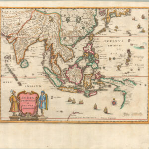
[Early color] Pieter Goos’ Striking Sea Chart of Southeast Asia, Australia, and the Indian Ocean.
Paskaerte Zynde t’Oosterdeel van Oost Indien, met Alle de Eylanden daer Ontrendt Geleegen van C. Comorin tot aen Japan
$6,500
1 in stock
Description
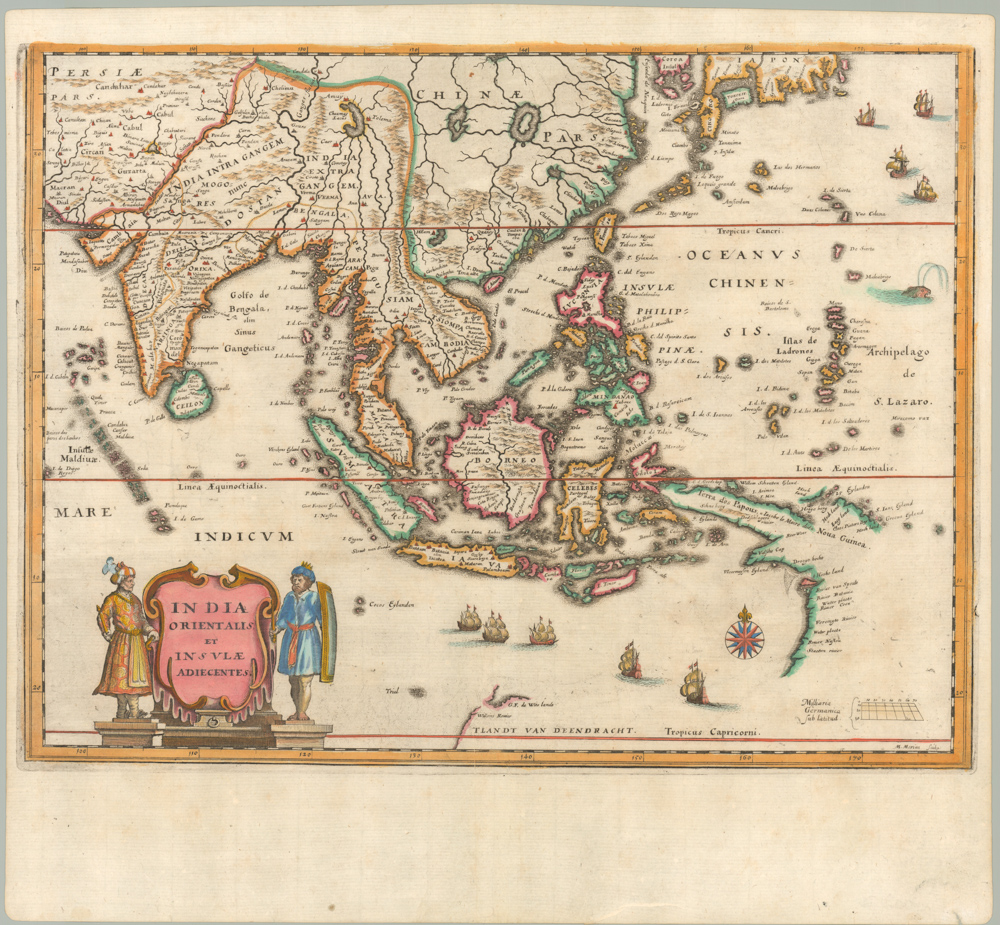
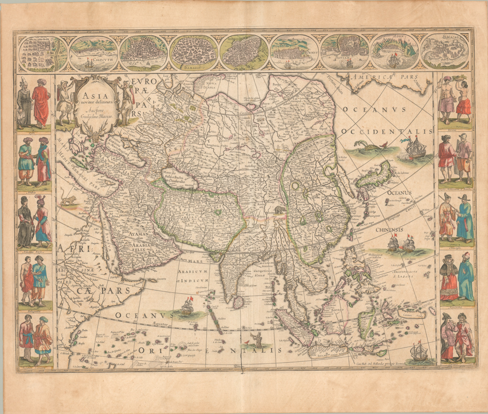
This beautifully engraved 17th-century sea chart by Pieter Goos depicts the vast maritime region from India and Cape Comorin to Japan and Korea, encompassing Southeast Asia, Australia (Nova Hollandia), and the Indian Ocean. First published in Goos’ Zee Atlas, this elegant and highly detailed navigation chart served as a vital reference for Dutch East India Company (VOC) ships traversing the lucrative spice trade routes between Europe and the Far East. The chart is oriented with east at the top and is divided by three prominent vertical lines marking the Tropic of Cancer (~23°N), the Equator (0°), and the Tropic of Capricorn (~23°S).
This map is one of two charts in Goos’ Zee Atlas that outline the VOC’s sea routes from Southern Africa to the Far East, faithfully following the course navigated by Dutch vessels in the Indian Ocean. The unfinished depiction of Australia (New Holland) is particularly notable, reflecting the explorations of Abel Tasman in 1644, who first charted the northern coastline but mistakenly believed New Guinea and Australia were part of a single landmass.
Dutch Exploration and Early European Encounters with Australia
By the early 17th century, Dutch ships had begun systematically exploring the southern latitudes of the Indian Ocean, following the Brouwer Route to Java, which was first tested in 1611 by Hendrick Brouwer and made mandatory for VOC ships soon after. This new faster, wind-assisted route inadvertently led several ships toward the western coast of Australia, resulting in some of the earliest recorded European encounters with the continent.
The Eendracht, captained by Dirk Hartog, was one such vessel that drifted too far east and landed on Western Australia in 1616. His crew left behind a pewter plate recording their discovery, marking the first known European landing on Australia’s west coast. This event is noted on the map with the inscriptions “Dirck Hertochs Ree” and “t’Landt de Eendracht ontdeckt A° 1616.” Other early Dutch landfalls appear on the chart, including:
- I. de Edels Landt (1619) – sighted by Jacob d’Edel and Frederik de Houtman.
- Houtman’s Abrolhos (1629) – the site of the infamous Batavia shipwreck and mutiny, which became one of the most infamous maritime disasters of the 17th century.
- Leeuwin (1622) – mapped by the ship Leeuwin, which lent its name to Cape Leeuwin, the southwestern tip of Australia.
- Gulde Zeepaert (1627) – commanded by Pieter Nuyts, it explored part of the southern coast.
The chart also incorporates place names from Willem Janszoon’s 1605-06 voyage on the Duyfken, the first documented European exploration of Australia’s northern coastline, particularly the eastern shores of the Gulf of Carpentaria.
By the 1640s, VOC officials sought more precise knowledge of the mysterious “South Lands.” They commissioned Abel Tasman to explore the region, culminating in his groundbreaking 1642-43 voyage, where he became the first European to reach Tasmania and New Zealand. His 1644 expedition, which followed the north coast of Australia, more accurately mapped the continent’s northern reaches, though he failed to recognize the Torres Strait and instead believed New Guinea and Australia were connected—an error reflected in this map.
Decorative and Cartographic Features
Beyond its navigational utility, the map is lavishly decorated in the Dutch Golden Age cartographic tradition. The lower left corner features an elaborate cartouche adorned with putti, adding an artistic flourish to the chart. At sea, three Dutch ships are depicted sailing eastward, symbolizing the VOC’s dominance over the region’s maritime trade routes.
The names on New Guinea reflect the 1615-16 expedition of Jacob Le Maire and Willem Schouten, a privately financed voyage that sought to circumvent the Dutch East India Company’s monopoly by discovering an alternative route to the Pacific. Their historic passage around Cape Horn opened a new gateway to the East Indies, and as they sailed along New Guinea’s northern coast, they named Willem Schouten Eylandt (modern Biak Island) and other locations.
This map’s exceptional engraving and geographic detail made it highly influential, serving as a prototype for later Dutch maritime charts. It was later copied and reprinted by notable cartographers, including John Seller, Frederick de Wit, Louis Renard, and R. & J. Ottens, attesting to its importance in 17th-century Dutch navigation.
Conclusion: A Masterpiece of Dutch Cartography
Pieter Goos’ chart is both a highly functional navigational tool and a stunning example of the artistry of Dutch mapmaking during the 17th century. It provides an invaluable window into early European exploration and trade in Southeast Asia and Australia, reflecting the growing geographic knowledge of the Dutch East India Company and its ambitions in the region. Its detailed portrayal of VOC trade routes, early Australian discoveries, and navigational landmarks makes it one of the most significant sea charts of its time, embodying the golden era of Dutch maritime dominance.
Cartographer(s):
Pieter Goos (1616–1675) was a Dutch cartographer, copperplate engraver, publisher and bookseller. He was the son of Abraham Goos (1590–1643), also a cartographer and map seller.
From 1666, Pieter Goos published a number of well produced atlases. He was the first to map Christmas Island, which he labelled “Mony” in his map of the East Indies, published in his 1666 Zee-Atlas (Sea Atlas). His Atlas ofte Water-Weereld (Atlas or Water World) has been cited as one of the best maritime atlases of its time.
Condition Description
Short margins, else excellent.
References
Koeman, Goos 3 (26); Parry, Plate 4.32; Clancy, p. 83 map 6.14.
Douglass, Bronwen. "Naming Places: Voyagers, Toponyms, and Local Presence in the Fifth Part of the World, 1500-1700." Journal of Historical Geography, vol. 45 (July 2014)