One of the key 19th-century maps of California.
Map of public surveys in California & Nevada to accompany report of commissioner of the general and office.
Out of stock
Description
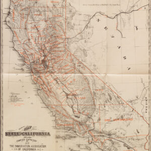
A remarkable and historically significant document of California in the early statehood period, this impressive 1866 map plots land surveys in the state and some parts of Nevada, including Lake Tahoe.
Surveyed land grants are listed in an index at the bottom-left, corresponding to areas indicated on the map itself. Counties are outlined in hand coloring to distinguish them easily. The location of land offices, railroads, mines, and more are noted. Old and atypical spellings of place names appear throughout, such as ‘Saucelas’ for Sausalito and ‘Los Angelos’ for Los Angeles. As depicted here, the borders of several counties would change over time; additionally, new counties were added (the last being Imperial County in 1907), while others disappeared (Klamath County in the northern part of the state).
The land grants reflect the status of California at the time, clearly retaining elements of its Spanish and Mexican past, namely presidios, large ranchos, and mission lands (including at Mission Delores in San Francisco). At the same time, the state’s present and future as a dynamic economic engine is evident, with thriving agricultural, mining, and fossil fuel industries.
Census
This map was produced by the U.S. Department of the Interior’s General Land Office and lithographed by Julius Bien in 1866 for inclusion in a report to the U.S. House of Representatives. The first edition was printed in 1863, containing much less detailed information. An 1865 printing (still dated 1863) highlighted railroad land grants and added some new information. Finally, the present edition, updated with much more color and detail, was printed in 1866; it was among the first large, colored state maps issued by the GLO. According to catalog listings in the OCLC, roughly 15 institutions hold this edition of the map.
Cartographer(s):
The General Land Office (GLO) was the independent government agency in charge of public lands. Created in 1812, it took over responsibility for public domain lands from the Department of the Treasury. Hitherto, the Treasury had done a decent job of overseeing the many surveys that were needed to map the lands of the Louisiana Purchase, including those taking place in the Northwest Territory. However, as land was added to the United States at an impressive rate in the 19th century, the government needed a new agency dedicated to surveying and planning the new lands. The establishment was a huge success, and over time the GLO would become responsible for surveying, mapping, and selling most of the land west of the Mississippi (except Texas).
In 1849, the GLO came under the auspices of the Secretary of the Interior, an office created that same year. Here it stayed until the creation of the Forest Service more than half a century later (1905). This made sense, since the GLO had been the office responsible for managing forested lands that had been extracted from the public domain, but remained the property of the State.
In addition to managing and selling land, the GLO conducted large scale surveys and produced maps and plans of the areas in question. In 1946, the GLO merged with the United States Grazing Service to become the Bureau of Land Management.
Condition Description
Good condition, with some wear and discoloration along fold lines. The verso is expertly backed with Japanese tissue paper. Some visible loss along fold lines.
References
![The Original Silicon Valley Map & Calendar [1994]](https://neatlinemaps.com/wp-content/uploads/2021/06/NL-00909_Thumbnail-300x300.jpg)
![The Original Silicon Valley Map & Calendar [1994]](https://neatlinemaps.com/wp-content/uploads/2021/06/NL-00909_Thumbnail.jpg)

![Flag Map of California [Signed in pencil by W.J. Goodacre]](https://neatlinemaps.com/wp-content/uploads/2022/01/NL-01134_thumbnail-scaled-300x300.jpg)
![Flag Map of California [Signed in pencil by W.J. Goodacre]](https://neatlinemaps.com/wp-content/uploads/2022/01/NL-01134_thumbnail-scaled.jpg)