From mysterious Vatican sources: The first accurate map of the Rio Grande and its tributaries!
Mexicum In hac forma in lucem edebat Ioannis Baptistae Nicolosii S.T.D.
Out of stock
Description
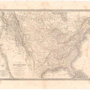
This is the rare first state of Giovanni Battista Nicolosi’s highly desirable four-sheet map of the North American continent. It was produced during the 1650s and published in 1660. In the context section below, we have provided a background on the atlas in which this map was issued and its maker. Here, we will focus on describing the map’s main features and importance in cartographic history.
Like all the continental maps in Nicolosi’s atlas, the North America map is divided into four equal sheets, covering the entirety of the continent, from Baffin Bay in the north to Panama and the Caribbean in the south. The map is a product of its time and was heavily inspired by Nicolas Sanson’s Amerique Septentrionale (1650). This can be seen in the detailed rendition of California as an island and how Nicolosi depicts the Great Lakes region. Lake Ontario remains unshaded (as in Sanson’s first map), and the toponyms for Canada include Quebec and Tadoussac, but not yet Montreal. All of this would change within a few short years of its publication.
Even though Nicolosi drew heavily on Sanson for his creations, some innovations set him apart and earned his charts “landmark status” in the cartographic history of the American West. The most significant feature is the orientation of Rio Escondido (i.e. Rio Grande), which Nicolosi is the first to depict correctly as flowing south-east from New Mexico into the Gulf of Mexico. Nicolosi’s rendition of the Rio Grande and its tributaries was a drastic departure from Sanson and other contemporary mapmakers, who mistakenly mapped a river flowing from a lake in the opposite direction, emptying into the Gulf of California. To this day, cartographic scholarship remains in doubt regarding Nicolosi’s sources for this revolutionary, accurate depiction of one of America’s most critical riverine systems.
A second state of this map was published in a post-humous edition of the atlas in 1671. This included a significant expansion of American toponyms, which makes it easily distinguishable from its forebear. Neatline’s example is the rarer first state, which the unshaded Lake Ontario and the exclusive use of R. Escondido for the Rio Grande can identify. The second state saw the inclusion of many more place names and historic sites, such as the location of Francis Drake’s landing in California.

Nicolosi and the Dell’ Ercole e Studio Geografico
Giovanni Battista Nicolosi (1610-1670) was a Sicilian priest and cartographer working for the Vatican in Rome. Motivated by the influential maps of French cartographer Nicolas Sanson (especially those in his 1653 Index Geographicus), the Propaganda Fide of Rome commissioned Nicolosi to produce an atlas that could rival Sanson’s. Over the next seven years, Nicolosi labored intensively to meet his employer’s demand, and the outcome would be one of the most essential Italian atlases produced in the 17th century.
Nicolosi’s Dell’ Ercole e Studio Geografico was published in Rome in 1660 and again in 1671 as a posthumous Latin edition. The title referred to a comparison between the labors of Hercules and those he had sustained to complete a full description of the earth. In the Ercole, Nicolosi presented large four-sheet maps of all the continents as they were known in the 1650s (Africa, North America, South America, Europe, and Asia – 22 plates in all). The atlas also contained a crucial double-hemisphere map of the world, which incorporated many continental map innovations on a global scale. The example offered here constitutes a highly well-preserved copy of the first state issued in 1660, complete with original outline color.
This map is the product of Nicolosi’s novel approach to global mapping. Essentially, he combined the traditions and perspectives of 16th-century Roman and Venetian mapmakers with the latest methods of contemporary greats, above all Sanson. This amalgamation of traditions and styles meant that Nicolosi could come up with an entirely new way of portraying the world, especially when it came to larger landmasses where the curvature of the Earth affected how such terrain could be shown correctly. Nicolosi was the first to employ the so-called pseudo-perspective projection in which the established meridians were perfected by complimenting circular parallels. Over the following decades, and especially during the early 18th century, this projection technique – also known as the globular projection – became increasingly popular and was applied by seminal cartographers such as Guillaume de l’Isle and Aaron Arrowsmith. In the decades after Nicolosi’s death, the globular or Nicolosi projection replaced the stereographic projection popularized by Mercator, which had increasingly fallen into disuse. During the 19th century, the Nicolosi perspective became the standard cartographic projection technique and remains used even today. In this way, when we try to understand how mapmakers have historically represented the shape of the world, Nicolosi belongs in a sequence that includes foundational figures like Ptolemy and Mercator.
The success of the Ercole — in particular, the new projection model — meant that Nicolosi soon began working on a new Latin version of his opus, which he intended for much wider distribution. As part of this new project, Nicolosi began remedying his previous somewhat conservative approach to mapping by including a range of new place names in the second state of the maps. The 1671 edition – now titled Hercules Siculus Sive Stadium Geographicum – ended up being published a year after Nicolosi’s death but had the intended effect of disseminating his models throughout Europe’s cartographic circles. This contrast between the first and second states is yet another reason why the original 1660 edition of his work has become so sought after by collectors and institutions.
Census
Neatline’s example of Nicolosi’s map constitutes a well-preserved example of the first state, as issued in 1660, complete with original outline color. It rarely appears on the market.
The OCLC lists a limited number of institutional holdings of the first state of this map, including at the Biblioteca Nacional de Espanha (no. 1091674737) and the Bayerische Staatsbibliothek (no. 165806037) in Europe and libraries such as Yale, University of Michigan, University of Texas, and the Osher Map Library (no. 84388798) in the United States.
Cartographer(s):
Giovanni Battista Nicolosi (1610-1670), also known as Giovan Battista, was a Sicilian priest, geographer, and cartographer who worked for the Vatican’s Congregation for the Evangelization of Peoples (or Propaganda Fide) under Pope Gregory XV. Officially, the Fide office was established to promote missionary work across the globe. Still, the reality was that it constituted an essential office for the maintenance and dilation of the Church’s power in an ever-expanding world.
Arriving in the papal capital around 1640, Nicolosi studied letters, sciences, geography, and languages. In 1642, he published his Theory of the Terrestrial Globe, a small treatise on mathematical geography, and a few years later, his guide to geographic study was issued, a short treatise on cosmography and cartography. Both works reflected a Ptolemaic worldview, but his guide to geographic analysis would soon serve as an introduction to Nicolosi’s real magnum opus, Dell’ Ercole e Studio Geografico, first published in 1660. On the other hand, his Theory of the Terrestrial Globe brought Nicolosi to the attention of broader scientific circles. It earned him the Chair of Geography at the University of Rome. In late 1645, he traveled to Germany at the invitation of Ferdinand Maximilian of Baden-Baden, where he remained for several years until he returned to Rome. Here, Nicolosi was appointed chaplain of the Borghesiana in the Basilica of Santa Maria Maggiore. This honor was conferred on him by Prince Giovanni Battista Borghese, whom Nicolosi had tutored and in whose palace he had lived since 1651. Years later, Nicolosi would thank the prince for his generosity by dedicating his most seminal work to him.
A considerable collection of Nicolosi’s unpublished work exists in the Vatican and other national archives. This includes a large chorographic (i.e. descriptive) map of all of Christendom, commissioned by Pope Alexander VII, and a full geographic description and map of the Kingdom of Naples, which was sent to Habsburg Emperor Leopold I in 1654.
Condition Description
Excellent. Minor blemishes. Outline color.
References
Burden 355; McLaughlin 23; Wheat 53; Leighly 38.