The American West Takes Shape.
A New Map of the State of California, the Territories of Oregon, Washington, Utah & New Mexico.
Out of stock
Description
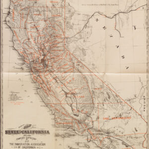
Based on his quintessential 1846 pocket map of California and Oregon, this is the 1854 edition of Samuel Augustus Mitchell’s map of the same territory, by then constituting the American West.
Gorgeous hand-coloring sets out the different counties and constituent parts of the states and territories. Cities and towns, forts, Native American groups, mountains, waterways, wagon routes and trails and other features are labelled throughout. Some curious features and long-lost placenames appear in California, the reflection of the rapid settlement and transformation of the state, such as a town of Fremont north of Sacramento.
Compared to earlier editions of the map, the Washington Territory is separated from Oregon, indicating the true date despite the copyright at bottom. However, the map was produced while negotiations on the U.S.-Mexico border were still ongoing and before the Gadsden Purchase was finalized, explaining the inclusion of alternative border arrangements as proposed by Bartlett and Graham.
This map appeared in the 1854 edition of Mitchell’s New Universal Atlas, published by Thomas Cowperthwait in Philadelphia.
Cartographer(s):
Samuel Augustus Mitchell (1790 – 1868) was an American geographer and bookseller. During the middle of the 19th century, he became the dominant commercial publisher of geographic materials in America.
Mitchell worked as a teacher of geography before turning to publishing, but he found the materials available to students both antiquated and lacking, so he decided to abandon teaching in favor of producing geographic textbooks and maps. He quickly became one of America’s greatest cartographic publishers and played a decisive role in making Americans aware of their country’s geography.
Thomas Cowperthwait & Co.Condition Description
Near Excellent.
References