An evocative and passenger-oriented overview of Northern California’s railroad infrastructure in the 1880s.
Map Showing the Summer Resorts on the Pacific Coast, adjacent to the lines of the Central and Southern Pacific Railroads.
$350
1 in stock
Description
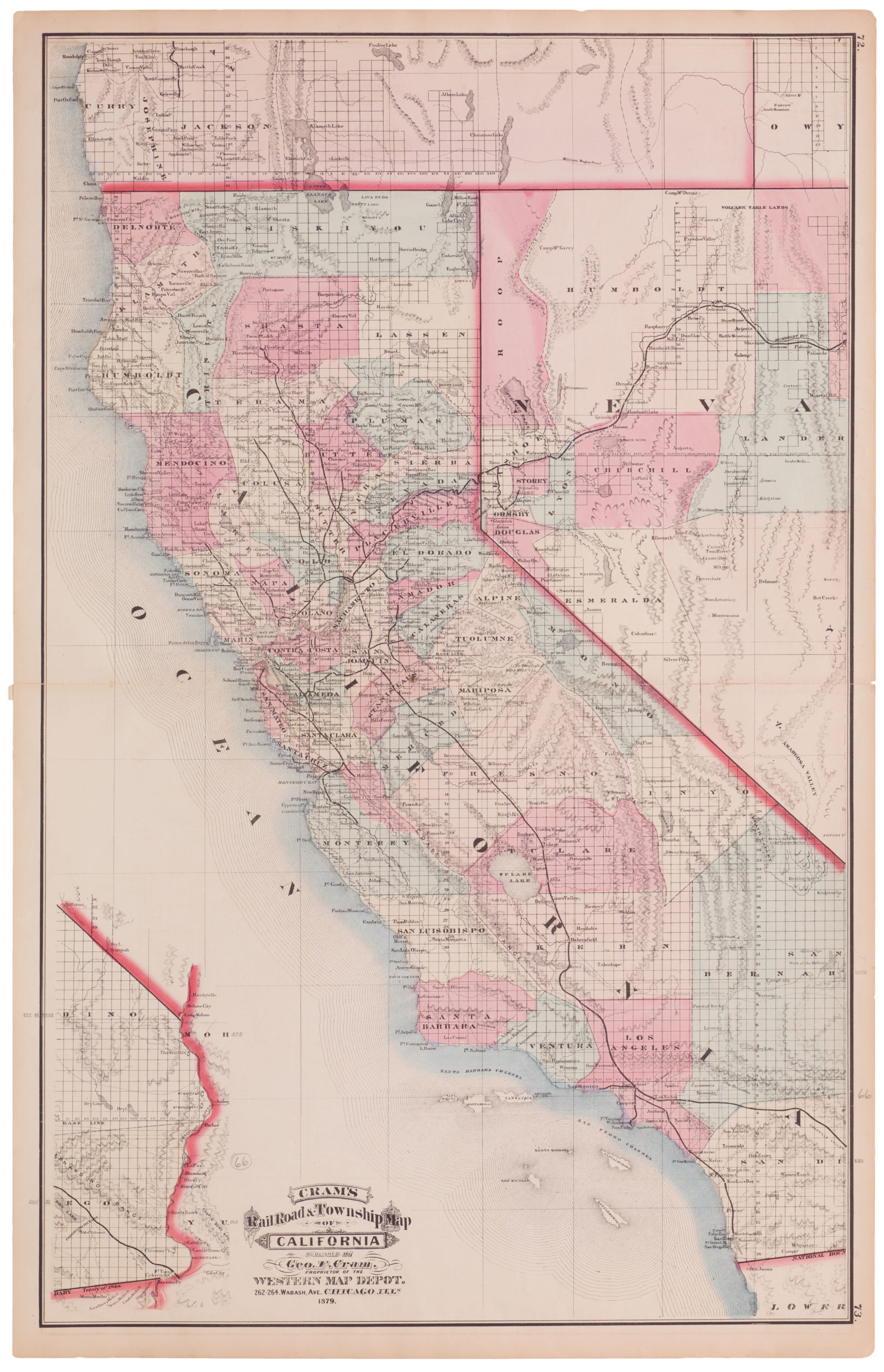
This antique railroad map for northern California is a compelling survival from the early age of travel. Published by the Southern Pacific Railroad in 1883, this folding passenger map shows the railroad systems surrounding the Bay Area. The map extends as far west as Lake Tahoe, Carson City, and the Yosemite Vally, north as beyond Yuba, and south as Fresno and Monterey. Among the iconic places depicted are San Francisco, San Jose, Madera, and San Andreas. It also shows well-known nature getaways such as Mariposa Grove, Calaveras, and The Geysers.
The map’s primary purpose is to depict the railroad lines that traverse this region and allow the many places to be visited by a growing number of ordinary people. Being dubbed a ‘map of summer resorts,’ the target audience is the increasing number of people traveling for leisure and holidays. Idyllic locations and known natural wonders feature prominently among the map’s many destinations.
Among the significant players governing travel by rail, we have the Central Pacific, Southern Pacific, and California Pacific (to Napa) Railroads, whose lines are highlighted in red on this map. In addition to these, a number of smaller lines have also been included to supplement and display the complete railroad infrastructure available. Minor railroads include the Amador & Ch. Railroad, the Sacramento & Placerville Railroad, the San Francisco & North Pacific Railroad, and the Virginia City & Truckee Railroad.
Along the right edge of the map, we see three tables from the publisher. The first shows ticket rates for a trip from San Francisco to either Monterey or Santa Cruz. Other priced destinations include Stockton, Sacramento, Marysville, Colfax, and Reno. Below the ticket rates is a table indicating travel time between San Francisco and Monterey or Santa Cruz. Finally, the lower table shows the timetable for trains from Marysville, Colfax, and Sacramento to Monterey and Santa Cruz.
The flanking tables are just a taste of what can be found on the verso of the map. Here are fifteen tables, one of which is the cover of the map when folded, informing passengers of additional routes, prices, and timetables. Despite being a Southern Pacific Railroad publication, two tables represent independent lines (i.e. Yosemite Valley and Geysers).
Cartographer(s):
The Southern Pacific Railroad, often simply referred to as the Southern Pacific, was one of America’s most influential rail systems, playing a critical role in the development and growth of the Western United States. Founded in the 1860s, its primary intention was to connect San Francisco and San Diego. However, over time, it expanded its vast network, spanning from the Pacific Coast to the Midwest, covering key states such as California, Arizona, New Mexico, Texas, and Louisiana. Its routes facilitated not only the movement of goods but also the migration of people, fostering connections between communities and accelerating the economic growth of the regions it touched.
The railroad wasn’t without controversies, particularly concerning its monopolistic practices and significant political influence during the late 19th and early 20th centuries. Nonetheless, its lasting impact is undeniable, with its legacy tracks still serving as vital arteries for transportation in the modern American West.
Condition Description
Folding map with wear and discoloration along folds.
References


![Flag Map of California [Signed in pencil by W.J. Goodacre]](https://neatlinemaps.com/wp-content/uploads/2022/01/NL-01134_thumbnail-scaled-300x300.jpg)
![Flag Map of California [Signed in pencil by W.J. Goodacre]](https://neatlinemaps.com/wp-content/uploads/2022/01/NL-01134_thumbnail-scaled.jpg)