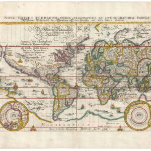
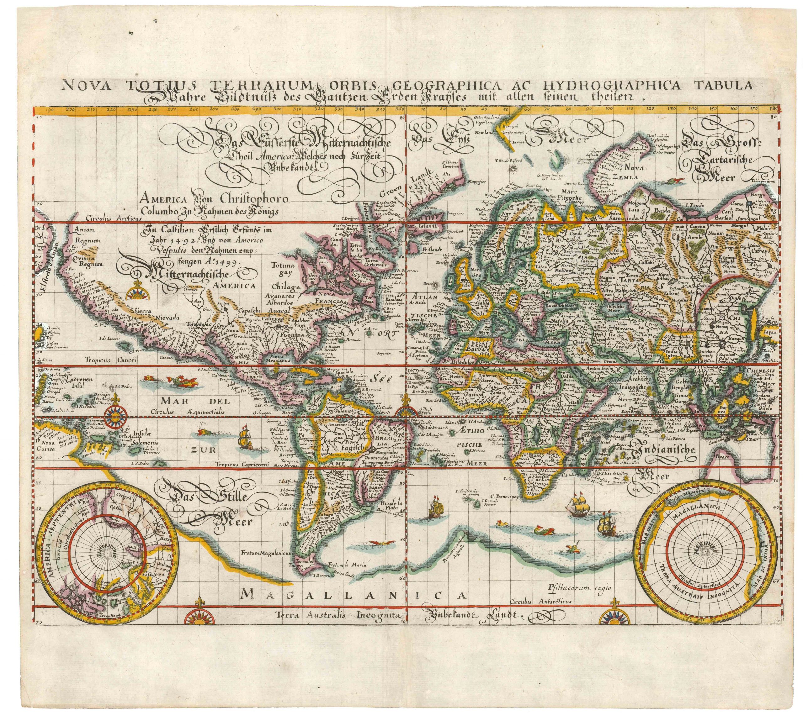
Coronelli’s masterful planisphere of the Old World with touches of original color.
Planisfero Del Mondo Vecchio, Descritto Dal P. Coronelli, Cosmographo Publico.
$2,200
1 in stock
Description
This unique planisphere of the world was compiled by Vincenzo Maria Coronelli at the pinnacle of his illustrious career. It combines the best geographical knowledge with the finest cartographic traditions.
Among the many elements that make Coronelli’s maps so important and collectible was his direct access to the latest French sources. This made him far more confident about inserting new features and pushing cartographical boundaries in his maps. These maps are no exception. Other appealing features include the decorative borders that enhance the aesthetic appeal and reflect Coronelli’s interest in astronomy and its relation to geography. This Old World map includes coordinates and descriptions of specific zodiacs along the outer rim of the chart, along with a triple band of latitudinal coordinates and meridians to complete the composition.
The map was created for Coronelli’s prestige project, the Atlante Veneto (1691), which he designed as a continuation of Willem Blaeu’s groundbreaking Atlas Maior. It was compiled in 1690, as indicated in the atlas’ frontispiece, but was not published until the following year. In addition to the compendium of geographical and scientific knowledge, the Atlante included an essential treatise on globe-making. Coronelli based this planispheres on his large globe gores from 1688 (Shirley 537), which presented the world from a distinctly Italian perspective.
Map features
The Old World planisphere gives us a comprehensive view of the eastern hemisphere – from Europe to East Asia, including Africa, most of Australia, and an enormous Antarctic continent. In general, we see that Dutch exploration and cartography play a significant role in informing Coronelli about the configuration of Southeast Asia. In particular, the depiction of Australia hinges on the expeditions of Abel Tasman. The Indonesian Archipelago and the Philippines are depicted in considerable detail, as is the Mariana Archipelago, although this retains the old Spanish name of Ladroni.
Africa is shown in its totality and with ample passage south of her Cape and into the Indian Ocean. This route was opened by the Portuguese in the late 15th century and was dominated by them for most of the 16th century. During the 17th century, however, French and Dutch merchants began challenging Portuguese dominion. Along the East African coast, the French, in particular, were actively trading and undermining the Portuguese presence. These new insights into East Africa are reflected in our map, which includes many toponymic details and a plethora of Indian Ocean islands surrounding Madagascar.
The most fascinating element is the excellent Antarctic continent at the bottom of the map, called Terre Australe Incognito. While the notion of such a continent can be traced back centuries and springs from the ancient Ptolemaic worldview, the feature is exciting at this stage in cartographic history. We note, for example, that despite being unexplored, it has a well-defined coastline, suggesting the presence of a continent and not just ice. Moreover, it extends well beyond the scope of the Antarctic Circle, which, in reality, is not the case (other than the Palmer Land Peninsula). It would only be with Captain James Cook’s sighting of the actual Antarctic landmass that an observation-based cartography of the South Pole was begun.
Concluding remarks
Coronelli’s map, with its intricate engravings and meticulous detailing, is a study of the exploding knowledge base for European mapmakers in the 17th century. This planisphere of the world was a prestige project meant to cement Coronelli’s position as one of the finest mapmakers of his day. It combines artistic elegance and geographical accuracy, still stands as a testament to his skill and ambition as a cartographer.
Cartographer(s):
Vincenzo Maria Coronelli (1650 – 1718) was a Franciscan printer, cartographer, and globe-maker from Venice. Due to his religious background, many of his charts have been signed P. Coronelli, meaning Père or ‘Father’, and referring to his status as a friar of the Franciscan Order. He was appointed official cosmographer for the city of Venice and was later employed as royal cartographer to the King of France. In particular the latter position meant that he had access to the latest records and materials from French pioneers and voyages of exploration. This caused many of his charts to be cutting-edge innovations that redefined the newly discovered parts of the world in an entirely novel fashion. It also meant that Coronelli would have no scruples in declaring uncontested or virgin land in the New World as part of Nouvelle France. This is exemplified in Coronelli’s celebrated 1685 chart of Western Canada or Nouvelle France, in which the official French territories have been expanded thousands of miles to the west and south, so that most of the Midwest, including the Mississippi Valley, has been subsumed under a French claim.
Coronelli’s access to the latest French sources and intelligence is part of what has made his maps so cartographically decisive and collectible. An example of this is found in his 1688 chart of upper Mexico and the Rio Grande (modern Arizona, California, and parts of New Mexico). This map was, at the time of its publication, one of the most detailed and accurate maps of the Rio Grande on the market. The detailed information conveyed in Coronelli’s map came directly from Diego Penalosa, the Spanish governor of New Mexico (1661-63) who turned rogue and provided the French King with a wealth of strategic geographical information. His ambition was to lure the French into attacking New Mexico from the neighboring territory of Louisiana. Despite the controversial source of his information (or perhaps precisely because of it), Coronelli does not hesitate to lay credit where credit is due, and mentions Penalosa directly in the map’s cartouche.
Condition Description
Touches of original color. Some wear along the lower edge and centerfold. Very nice.
References