Highly sought after by collectors of Texas and German-American history.
Karte von Texas.
$6,000
1 in stock
Description
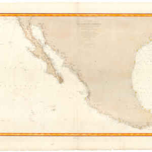
This rare map of the independent Republic of Texas (1836-45) was published with Georg Scherpf’s influential emigré guide: Entstehungsgeschichte und gegenwärtiger Zustand des neuen, unabhängigen, amerikanischen Staates Texas. This book was praised at home and abroad for its comprehensive and accurate coverage of the new republic, including its historical creation, current administration, and core characteristics.
Explicitly written for German immigrants moving to America, this was one of only three works officially recognized by the Mainzer Adelsverein (Mainz Nobility Society). The Adelsverein was a German emigrant company established in Biebrich on the Rhein in 1842 and formed with the explicit intention of creating a new German colony within the young Texan Republic.
Scherpf based his map on the seminal predecessor by Hunt & Randel from 1839, which also depicted the new Republic in great detail. In addition to the old Texas land grants and settler colonies (e.g., Burnet, Robertson, Zavala, Austin, Milam, DeWitt, McMullen & McGloin, Powers, and De Leon), Scherpf’s map delineates county borders and plots in both old (e.g., Bexar and San Felipe) and new towns (e.g., Houston and Austin). He also depicts critical infrastructure such as forts, mines, settlements, and roads. Even the first projected railroads have been drawn onto the map.
More historical attributes have been addressed, too. The old Spanish roads and missions are shown, and east of the Red Fork River is the area in which General Rusk pillaged and burned the villages of the local Caddo Peoples. Similarly, specific areas in which Native American peoples still resist colonization are labeled as such, with the Comanches along the western frontier of Texas being the most dominant group. Generally, one gets a clear sense that this is a frontier map. A note along the West Fork of the Trinidad River (just east of the Caddo villages) indicates large swathes of land suitable for European settlement, and I highlighted the northwest part of the Republic for the abundance of Buffalo. Natural landmarks such as peaks, ranges, and rivers are also prominently included.
Scherpf provided one of the first comprehensive accounts of the Texas Republic, covering not only its brief history and colonization but also the republic’s geography, agriculture, living conditions, and all manner of practical advice for migrants. His guide was considered one of the most important German-language publications on Texas, in part because it had been written by a long-time resident. Scherpf’s book was a significant inspiration for the development of the Adelsverein, which eventually evolved into the Society for the Protection of German Immigrants in Texas.
Census
The OCLC notes the presence of two editions of Scherpf’s guide in 18 institutional collections in Europe and the United States (no. 1152696536).
Context is Everything
The Republic of Texas was an independent sovereign state in North America from 1836 to 1846. Tensions between American settlers in the Mexican territory of Tejas and the Mexican government primarily drove its creation. These settlers, many of whom were from the United States, chafed under Mexican laws—particularly the prohibition of slavery and the requirement to convert to Catholicism.
These tensions culminated in the Texas Revolution in 1835. Following several battles, including the famous siege of the Alamo, Texan forces led by Sam Houston secured a decisive victory at the Battle of San Jacinto on April 21, 1836, capturing Mexican President Santa Anna and securing de facto independence.
The Republic of Texas was officially declared on March 2, 1836. It faced immediate challenges, including diplomatic recognition, a lack of defense against potential Mexican retaliation, and internal political and financial instability. Despite these challenges, the Republic established a government and won formal recognition from several countries, including the United States, France, and the United Kingdom.
Annexation to the United States was a contentious issue due to concerns over slavery and the balance of power between slave and free states. However, the desire for stability and protection ultimately led to the Republic seeking union with the U.S. In 1845, the U.S. Congress passed a resolution to annex Texas, which Texas accepted. On December 29, 1845, Texas was admitted to the Union as the 28th state. This annexation contributed to the outbreak of the Mexican-American War in 1846, as Mexico had never formally recognized Texan independence and viewed the annexation as an act of aggression.
Cartographer(s):
Georg A. Scherpf was a German mapmaker based in Texas. Not much is known about him, but he appears to have resided in Texas for several years during its state as an independent Republic. In 1840, he reportedly traveled with A.B. Lawrence from Houston to Austin, providing brief notes on critical heroes like Moses Austin and David Crockett. In 1845, after Scherpf had relocated to the East Coast, The Society for the Protection of German Emigrants to Texas noted that Scherpf had resided in independent Texas for many years before settling in New York.
Hunt & RandelHunt & Randel: The map’s title notes that this map builds on a template created by Hunt and Randel. Richard S. Hunt and Jesse F. Randel published their essential Guide to the Republic of Texas in 1839, including a rare map. According to Streeter, “…it must have been a useful book for […] settlers, and its contemporary account of existing conditions makes it a valuable book now.”
Condition Description
Excellent.
References
![[1838 Republic of Texas manuscript document detailing the votes for elected office, including President].](https://neatlinemaps.com/wp-content/uploads/2023/06/NL-01852-front_thumbnail-300x300.jpg)

