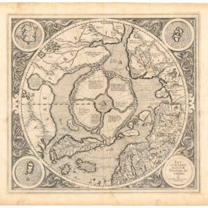
A superb original color example of Mercator’s famed map of the North Pole.
Septentrionalium Terrarum descriptio.
Out of stock
Description
The second state of Mercator’s seminal view of the Arctic: an excellent example of a map that stands above all others for its groundbreaking subject matter and the ingenuity of its execution.
Gerard Mercator, a key figure in European mapmaking during the latter half of the 16th century, produced some of the most influential maps of the era. His most significant contribution was the creation of a new cartographic projection to tackle the issue of magnetic declination. Mercator’s large 1569 wall map fundamentally transformed the process of compiling and designing European charts, marking a paradigm shift in cartography. However, this was not his only significant achievement. In 1595, a year after his death, Mercator’s Atlas sive cosmographicae meditationes de fabrica mundi et fabricati figura was published posthumously.
Mercator’s motivation to compile this chart was anchored in his wall map. Because the Mercator projection compensates for magnetic declination by stretching the regions closer to the poles, including the poles would have meant warping them beyond recognition. Instead, an inset map of the North Pole was added to the lower left corner. In 1595, Mercator published an expanded and updated version of that inset, explicitly designed to adorn the new atlas that Mercator was compiling late in life. It was the world’s first separately conceived map dedicated to the North Pole. The example offered here was published by Rumold Mercator shortly after his father’s death.
There are some features of the map that we wish to highlight:
- The Indrawing Seas: The North Pole is shown as a tall black rock (Rupes Nigra et altissima) standing freely in the water and measuring an impressive 33 French miles in circumference (Taylor 1956). This rock is surrounded by four large landmasses, which in turn are divided from each other by four great rivers that flow north towards the pole. In a letter to John Dee, Mercator describes the water around the rock as a whirlpool in which ‘the water rushes round and descends into the Earth.’
- A second large rock is found near the Strait of Anian (separating America and Asia), to which Mercator ascribes the magnetic properties that govern the navigator’s compass. In this way, he continues to address the phenomenon of declination by establishing a geographic and magnetic North Pole on his map.
- Anomalies of early America: This map was Mercator’s only serious attempt to define the full extent of America’s northern coastline. Among the notable features, we see an enormous lake labeled Lago de Conibaz, which feeds two rivers that empty into an excellent bay north of the Strait of Anian. This bay and a massive river to the south of it carve out three large peninsulas along America’s northwest coast. The most proximate of these to the pole is labeled California regio and includes a note that this territory is known only to the Spaniards. These features are direct departures from the 1569 template that Mercator was building on. Even more interesting is that the North America map (America sive India Nova) issued in the same atlas as our map does not contain these features (i.e. the lake/bay constellation, the tripartite northwest coast, and the toponym California associated with the Arctic). While we know that the Lake Conibas concept was adapted from the 1575 map of André Thevet (who in turn was informed by Cartier’s reports), it seems the other features were Mercator’s own inventions.
- Frisland: The mythical island of Frisland is not only represented on the main map (towns and all) but is also shown in more detail in an inset in the upper left corner. Frisland was a cartographic myth commonly found on 16th-century maps of the North Atlantic. The concept originally came from the Venetian Nicolo Zeno the younger, who, in 1558, published a map that he claimed was based on rediscovered travel records of his ancestors Nicolo and Antonio Zeno, who supposedly explored the coasts of Greenland and Labrador in the 14th century. Most modern historians consider the map a hoax, but in the 16th century, mapmakers widely used it as a source for the North Atlantic.
- Mercator’s sources: Part of what makes this map so compelling is its sources. In addition to the Zeno map, we know from a letter to John Dee that Mercator used the account of a 14th-century Dutch traveler named Jacob Cnoyen van Tsertoghenbosche, who in turn drew on a now lost work, known as the Inventio Fortunata. This enigmatic tome provides various accounts of the northernmost lands, including one of a 6th-century invasion by King Arthur at the head of 4000 men. The Dutchman also relays an experience from the court of Norwegian king Håkan Magnusson (1340 – 1380), in which he met and interviewed travelers from the distant north, including a priest carrying an astrolabe.
Cartographer(s):
Gerardus Mercator (March 1512 – 2 December 1594) was a 16th-century geographer, cosmographer, and cartographer from the County of Flanders. He is most renowned for creating the 1569 world map based on a new projection that represented sailing courses of constant bearing (rhumb lines) as straight lines—an innovation that is still employed in nautical charts.
Mercator was one of the pioneers of cartography and is widely considered the most notable figure of the Netherlandish school of cartography in its golden age (approximately 1570s–1670s). In his own day, he was notable as a maker of globes and scientific instruments. In addition, he had interests in theology, philosophy, history, mathematics, and geomagnetism. He was also an accomplished engraver and calligrapher.
Condition Description
Very good. Old color. Some uneven toning, foxing, and creasing along top edge. Adhesive residue on verso from earlier framing.
References
Van der Krogt, P.: Koeman's Atlantes Neerlandici, 0020:1A; Burden, P.D.: The Mapping of North America No. 88; Kershaw, K.A.: Early Printed Maps of Canada I. 1540-1703. No. 22; Ginsberg, W.B.: Septentrionalium Regionum - The Mapping of the Northern Regions 1482-1601, No. 33.
E.G.R. Taylor (1956) A letter dated 1577 from Mercator to John Dee. Imago Mundi 13: 56–68.