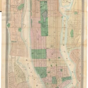
1689 Coronelli-Nolin Map of Eastern Canada and the Northeastern United States.
Partie Orientale du Canada ou de la Nouvelle France…
$5,000
1 in stock
Description
Coronelli’s Masterpiece of the French Atlantic World
This is a beautiful example of Vincenzo Coronelli and Jean Baptiste Nolin’s 1689 map of Eastern Canada and the Northeastern United States, one of the most important and finely detailed French colonial maps of the North American seaboard produced in the 17th century.
Drawing on an ambitious synthesis of the most current French and English geographic sources, it is described by Kershaw as “probably the best 17th century representation of eastern Canada and the eastern seaboard of America.” The present example is an attractive, well-colored impression of the third state of four — the first to properly credit the contributions of Jean Nicolas du Tralage (Sr. Tillemon) and featuring additional annotations, place names, and a legend not found in the first edition.
The Map in Detail
Coverage extends from the junction of Lakes Ontario and Erie in the west to the Grand Banks off Newfoundland in the east, from 60° north along the sharply angled Labrador coast to approximately 32° south, taking in the Carolina coastline. The familiar geography of the eastern seaboard — the Carolina barrier islands, Chesapeake Bay, Delaware Bay, Long Island, and the New England coast — is rendered with considerable accuracy and reflects familiarity with the most current English mapping of the period, including an updated treatment of the Chesapeake. The Gulf of St. Lawrence’s major islands, including Anticosti, Île de Saint-Jean (Prince Edward Island), and Cap Breton, are recognizable, though smaller islands are exaggerated in size.
The cartouche in the upper left is surmounted by a deer and a beaver. It is flanked by two Native American figures — one armed for the hunt with a bow, the other for war with a musket and distinctive wooden-plank armor. A shell-motif cartouche in the lower right presents the map’s scales, while the waters are enlivened with two figures paddling a canoe and menaced by a pair of vigorously rendered sea monsters. The third state adds a legend to the left of the cartouche identifying French forts and islands, as well as annotations at the bottom treating the English possessions in the New World, the Dutch discovery of New Amsterdam, and related matters. Boston is correctly named in this edition, as are the Kennebec town and river.
Most striking politically is the placement of the Franco-English boundary squarely in the vicinity of Albany, with Lake Champlain and the Great Lakes firmly within the French sphere — a territorial assertion considerably more aggressive than the geographic reality of 1689.
Historical Context
By the 1680s, the growth of French colonial ambitions in North America had created urgent demand for an authoritative map of the region, and Coronelli — the celebrated Venetian cosmographer working in close partnership with Parisian publisher Jean Baptiste Nolin — answered that call with this map, engraved in Venice and published in Paris. The sources were remarkably current: Franquelin’s manuscript map of 1681 and Hennepin’s map of 1683 informed the treatment of Labrador, while the Grand Banks were drawn from G.B. du Bocage’s 1678 survey.
A few fascinating survivals from older geographic traditions persist alongside this modernity: the Monts d’Apalatay in the Carolina interior echo Le Moyne’s 1591 map, and the phantom placename Estotiland lingers on the Labrador coast, a ghost from the notorious Zeno chart of 1558. The identity and precise contribution of “Sr. Tillemon” — Jean Nicolas du Tralage, a well-connected geographer whose uncle served as a lieutenant general in Louis XIV’s police — remain somewhat ambiguous. No clear cartographic differences distinguish the third state from the first, raising the possibility that du Tralage’s credit was added to Nolin’s maps broadly, perhaps as much for political patronage as cartographic contribution; the favor of his uncle, whose authority extended over censorship, may well have been essential to Nolin’s ability to publish at all.
Publication History and Census
The map was engraved in Venice and first published by Vincenzo Coronelli and Jean Baptiste Nolin in 1689. Four states are recorded. The first state (1689) carries Nolin’s address at “le Quay de l’Horologe du Palais, prochue la Rue de Harlay”; the second state (c. 1690) updates this to “prochue le Pont Neuf”; the third state (c. 1690), the present example, removes the original dedication and adds the credit to Sr. Tillemon; the fourth and final state (1704) updates the date accordingly. The map is well represented in institutional collections but is genuinely scarce on the private market.
Cartographer(s):
Jean-Baptiste Nolin (c. 1657–1708) was a French cartographer and engraver.
Vincenzo CoronelliVincenzo Maria Coronelli (1650 – 1718) was a Franciscan printer, cartographer, and globe-maker from Venice. Due to his religious background, many of his charts have been signed P. Coronelli, meaning Père or ‘Father’, and referring to his status as a friar of the Franciscan Order. He was appointed official cosmographer for the city of Venice and was later employed as royal cartographer to the King of France. In particular the latter position meant that he had access to the latest records and materials from French pioneers and voyages of exploration. This caused many of his charts to be cutting-edge innovations that redefined the newly discovered parts of the world in an entirely novel fashion. It also meant that Coronelli would have no scruples in declaring uncontested or virgin land in the New World as part of Nouvelle France. This is exemplified in Coronelli’s celebrated 1685 chart of Western Canada or Nouvelle France, in which the official French territories have been expanded thousands of miles to the west and south, so that most of the Midwest, including the Mississippi Valley, has been subsumed under a French claim.
Coronelli’s access to the latest French sources and intelligence is part of what has made his maps so cartographically decisive and collectible. An example of this is found in his 1688 chart of upper Mexico and the Rio Grande (modern Arizona, California, and parts of New Mexico). This map was, at the time of its publication, one of the most detailed and accurate maps of the Rio Grande on the market. The detailed information conveyed in Coronelli’s map came directly from Diego Penalosa, the Spanish governor of New Mexico (1661-63) who turned rogue and provided the French King with a wealth of strategic geographical information. His ambition was to lure the French into attacking New Mexico from the neighboring territory of Louisiana. Despite the controversial source of his information (or perhaps precisely because of it), Coronelli does not hesitate to lay credit where credit is due, and mentions Penalosa directly in the map’s cartouche.
Condition Description
Very good. Centerfold reinforced; else excellent with generous margins.
References
Burden, P., The Mapping of North America, #657 State 3. Kershaw, Kenneth A., Early Printed Maps of Canada, #161 (2nd state). McCorkle, B. B., New England in Early Printed Maps 1513 - 1800, #689.2.