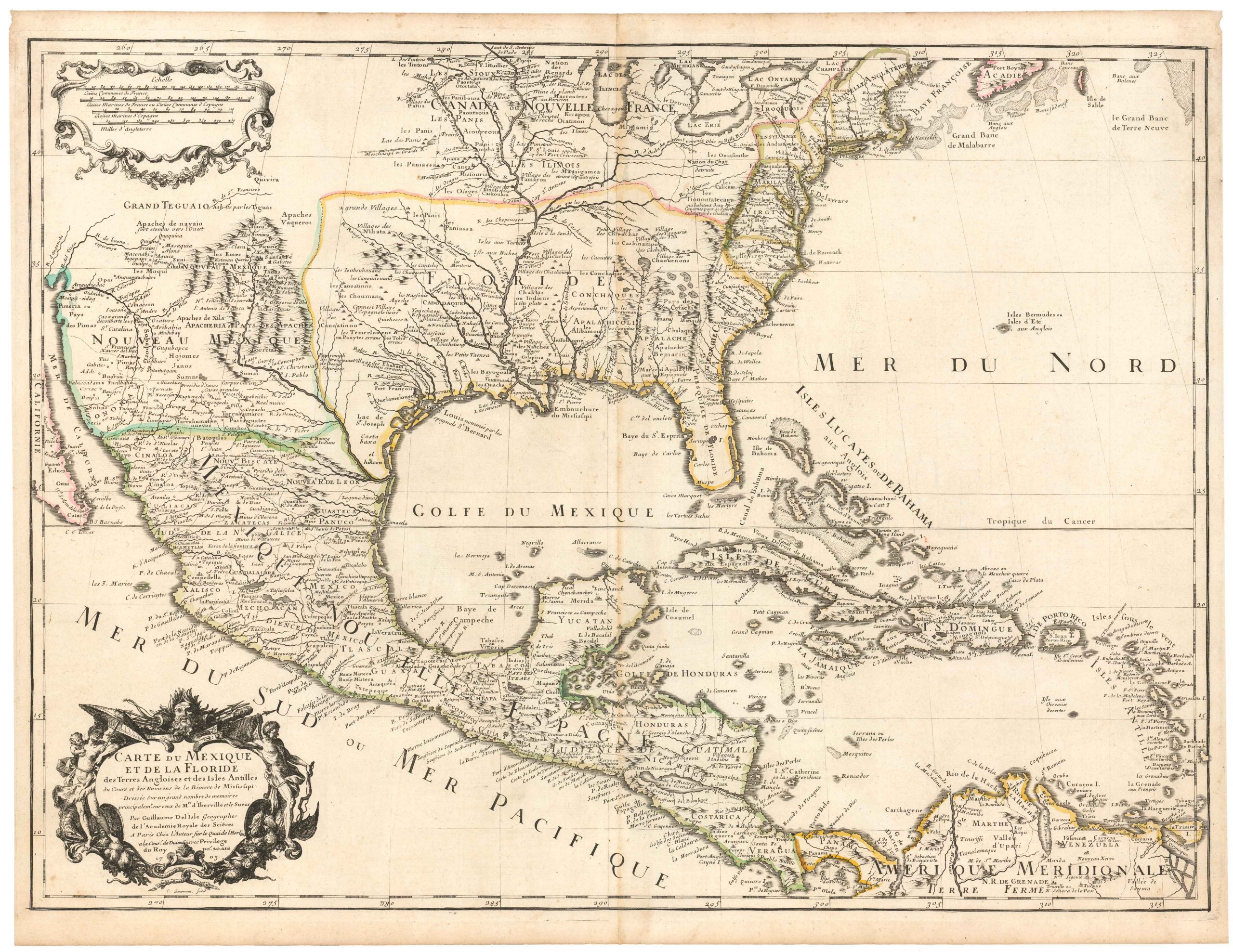
The earliest acquirable map to name California.
Americae Sive Novi Orbis, Nova Descriptio.
$4,800
1 in stock
Description
Abraham Ortelius’ 1587 map of the Western Hemisphere presents a rich and detailed view of the American continents as they were understood in the late 16th century. Neatline’s example is the map’s third and final state, distinguished by its more refined coastline and sophisticated aesthetic.
In this state, the exaggerated bulge previously shown along the west coast of South America has been corrected, and Ortelius’ name has been inscribed in the lower right of the plate, affirming his role as the creator. Moreover, several decorative features, such as vignettes of ships, have been added to the plate.
California and the Pacific Northwest
Among the stand-out features of this map is the early American toponymy. Perhaps the most iconic of all place names is the early application of the term California, which we find in two places on this map. The original labeling identifies the tip of the Baja Peninsula as C. California. This toponym was part of the original map and figures in the map’s first state from 1570. It is only the third time in history that the term California was used on a printed map. It was only preceded the now scarce map of the Americas by Diego Gutierrez (1562) and the equally rare cordiform world map by Ortelius from 1564, in effect making this chart the earliest acquirable map to apply this place name. The label has also been printed onto the Baja Peninsula in this third state of the map.
The strange delineation of the Northwest Pacific reveals how early we are in the history of American cartography. However, new place names, such as R. de los estrechos and C. Mendocino, are introduced for the first time on this map. Two more storied toponyms – Anian and Quivira – also appear along the northwest, referencing some of the exploration mythology that was popular at the time. Rather than naming the unknown northern lands it labels, Anian was a standard reference to the strait separating North America from Asia. This concept and the associated term were introduced by Giacomo Gastaldi in 1565. On the other hand, Quivira was a mythical indigenous city that Ortelius placed on a large coastal promontory just west of the Sierra Nevadas.
The Atlantic and Southern Hemisphere
While the West Coast constitutes the unknown frontier at this stage, the map also captures some of the ongoing English efforts to colonize the Atlantic coast. This is seen in using Native American toponyms such as Wingandekoa for the area around present-day North Carolina. The large inlet nearby may be the earliest printed depiction of Chesapeake Bay.
A cornucopia of gorgeous vignettes populate the oceans, including fourteen individual ships in the Pacific and eleven in the Atlantic/Caribbean. To clinch the composition, a sea monster prowls the waters off Argentina. The map’s ornate strapwork border and embellished title cartouche add a Renaissance aesthetic typical of Ortelius’s work. These decorative elements lend the map an imaginative and dynamic quality.
The Southern Hemisphere includes an expansive Terra Australis, which connects Tierra del Fuego to New Guinea, maintaining the speculative notion of a vast southern continent. Another notable addition to this third state is the Solomon Islands, which had only been discovered by Spanish explorer Álvaro de Mendaña in 1568.
Census
Americae Sive Novi Orbis Nova Descriptio first appeared in Ortelius’s groundbreaking Theatrum Orbis Terrarum, published in Antwerp in 1570. The atlas saw great success, undergoing multiple editions and translations into various languages. BY 1612, at least 31 editions had been published. The present map is the third state, which was produced from a new copper plate in 1587 (see note in the lower right corner of the map).
The map’s first edition (1570) included a westward bulge along South America’s coast and a single prominent ship in the Pacific. Ortelius revised the map for a second edition in 1579, making subtle changes in the cartographic and decorative details but retaining the bulge. Finally, the third edition (1587) corrected the South American coastline, added new place names on both American coasts, and reworked most of the maritime sphere.
The third state was widely used in the Theatrum between 1587 and 1612.
Cartographer(s):
Abraham Ortelius (1527-1598) was born in Antwerp to Flemish parents in 1527. After studying Greek, Latin, and mathematics, he and his sister set up shop as book dealers and a ‘painter of maps.’ In his heart, Ortelius was, nevertheless, first and foremost a historian. He believed geography was the ‘eye of history,’ which explains why he collected maps and historical documents with such passion. Ortelius traveled widely in pursuit of his interests, building contacts with mapmakers and literati all over the European continent.
Ortelius reached a turning point in his career in 1564 with the publication of a World Map in eight sheets, of which only a single copy survives. In 1570, he published a comprehensive collection of maps titled Theatrum orbis terrarum (Theatre of the World). The Theatrum is conventionally considered the first modern-style atlas. It was compiled by collecting maps and charts from colleagues across the continent, which Ortelius then had engraved in a uniform size and style. The engraver for most of the maps in Theatrum was none other than the famous Frans Hogenberg, who also served as the main engraver for the 16th-century urban atlas Civitates Orbis Terrarum, published with Georg Braun in 1572.
Hogenberg’s re-drawn and standardized maps formed the basis of the first atlas in history (even though it was Mercator who was the first to use the term a few decades later). Unlike many of his contemporaries, Ortelius noted his sources openly and in the first edition, acknowledged no less than eighty-seven different European cartographers. This ‘catalogus auctorum tabularum geographicum‘ is one of the major innovations of his atlas. The list of contributing mapmakers was kept up-to-date for decades after Ortelius’ death. In the first edition of 1570, this list included 87 names, whereas the posthumous edition of 1603 contained no less than 183 names.
While compiled by Abraham Ortelius in the manner described above, the Theatrum was first printed by Gielis Coppens van Diest, an Antwerp printer experienced with cosmographical books. Van Diest was succeeded by his son Anthonis in 1573, who in turn was followed by Gillis van den Rade, who printed the 1575 edition of Ortelius’ atlas. From 1579, Christoffel Plantin took over, and his successors continued to print Theatrum until Ortelius’ heirs sold the copperplates and the publication rights to Jan Baptist Vrients in 1601. In 1612, shortly after Vrients’s death, the copperplates passed to the Moretus brothers.
Condition Description
Left margin reinforced with paper on verso. An original plate crack is visible in the upper right hand corner.
The verso of this map is blank, which is not common. Ortelius preferred to place text on the back of his maps, but this was not important to all buyers, who could visit the Plantin publishing workshop and have the map pulled immediately as desired.
References
Broecke, Marcel Van den. Ortelius Atlas Maps: an illustrated guide. 2011, Ort11.
Burden, Philip D. The Mapping of North America a List of Printed Maps, 1511-1670. Rickmansworth: Raleigh Publications, 1996, 88.