The first large-format map of Washington Territory.
Map of Washington Territory West of the Cascade Mountains.
On Hold
Description
A masterpiece of American cartography.
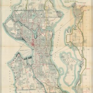
Charles A. White’s rare and impressive Map of Washington Territory West of the Cascade Mountains was the first printed wall map of Washington compiled during its tenure as a U.S. Territory (1853-1889). Issued in 1870 as a collaboration between Charles A. White, George Woolworth, and Charles B. Colton, the map is of seminal importance in the historical cartography of the United States. Its publication came between periods of explosive demographic growth in this distant corner of America and is a keystone in any collection focused on the development of the Pacific Northwest.
With every inch representing only four miles, the chart encompasses countless details and served as a template for understanding the development of the Washington Territory during these formative years. It was built on actual surveys of the region, including U.S. Government Land Surveys, Coast Surveys, and General Land Office Township Surveys, elements of which have been incorporated into the map. Along the eastern edge, the Cascade Mountains are dramatically represented, with important summits like Mt. Rainier, Mt. Baker, Mt. Saint Helens, and Mt. Adams highlighted. Elevations and topography west of the Cascade Mountains exhibit the same artistic flair and attention to detail.
Nautical approaches are also a subject of considerable focus. An extensive and intricate coastline, stretching from Vancouver Island and the Salish Sea to Puget Sound, is marked by continuous depth soundings, just as wetlands and mud flats are marked on the map to prevent keeled ships from running aground. Admiralty Inlet is featured, and in the north, the San Juan Islands and Bellingham Bay are well charted.
A Boom in the Pacific Northwest
In addition to its overall splendor and primacy, several specific features make White’s map one of the most desirable pieces of Pacific Americana. The years leading up to its publication saw a massive influx of emigrants to Washington Territory; the registered population more than doubled between 1860 and 1870. This map was produced at the tail end of that growth curve and is filled with explicit manifestations of this boom. In addition to an abundance of unassigned and fertile farmland, one of the big attractions for emigrants was the ever-growing timber industry, seen here in the careful plotting of the region’s sawmills. Other natural resources, such as the coal mines near the Skookumchuck and Whatcom Rivers, are also indicated.
Yet, while the 1860s may have drawn many new settlers to the Territory, the boom was only beginning. In the decade that followed this map’s publication, the official population of Washington Territory more than tripled in size. A critical factor in this massive growth was the commencement of the Northern Pacific Railroad, the very same year this map was issued. In fact, this enormous project likely motivated the creation of a large-scale commercial map in the first place.
The Northern Pacific Railroad
In 1870, work began on a new northern continental railroad. Commencement was delayed a few times, but once it got going, it generated nationwide optimism about the future of this remote part of the country. While the new continental railroad was only completed in 1883, the project entailed work, land, and trade opportunities from the get-go. Among the respondents was the Colton Firm, whose success hinged on creating maps that correlated with the expansion of the railroad. This map was no different, as it tapped into a market for pioneer romanticism from which American mapmakers had profited for some time. The new railroad’s crucial role in the commercial publication of this map is especially evident in the land corridor through which the envisioned railroad’s end stretch would pass. Note, for example, the disproportionate and almost excessive level of detail in the tract between Monticello in the south and Admiralty Inlet in the north.
The course chosen for the new railroad would become the most decisive factor in the development of this part of Washington over the next few decades. A good example is the small town of Tacoma, which grew up around a sawmill and, in 1870, consisted of about 100 people. It was hardly a place that merited the prominent inclusion it receives on this map. However, three years after this map was published, Tacoma was formally selected as the terminus of the Northern Pacific Railroad over Seattle. The consequence was that by 1880, more than a thousand people lived there, and by the time the railroad was finished and operational, the population had risen to 30,000.
The selection of Tacoma as the terminus for the new railroad was a blow to Seattle, but it was still one of Washington’s most rapidly growing towns and would continue to retain its dominant role in the region. In 1870, around 1,100 people lived in Seattle, but this number would grow at a similar rate to Tacoma over the coming decades. The settlement on the map consists of a few black blocks covering less than a square mile, extending to Elliott Bay. It’s also the endpoint of the Oregon Trail, a key part of the city’s historical growth. Across Admiralty Inlet, we note the presence of two more sawmills on Bainbridge Island.
Census
Charles A. White’s map of Washington Territory was produced in two states, published only months apart, and with limited revisions distinguishing them. Our example is the first state, identifiable by the lack of a copyright attribution to Hazard Stevens that is present in the second state. Both states of this map are scarce on the market.
The OCLC lists only fifteen institutional copies worldwide (no. 1034921905). Among them, we note the map’s presence in key collections like the Library of Congress (call no. G4280 1870 .W4), the Beinecke Library at Yale University (call no. 847 1870), The David Rumsey Collection (call id. 2462.006), and in the Special Collections of the Newberry Library (no. ocm36322044).
Both the Beinecke and the Library of Congress attribute the map to Charles Abiathar White (1826-1910), an Iowa state geologist who also participated in several U.S. Geological Surveys of the West. Despite the logic of this attribution, an alternative interpretation sees the mapmaker as a civil engineer of Swedish origins who worked out of Olympia, Washington (see mapmaker bio).
Cartographer(s):
The attribution of this map is something of a mystery. For a long time, there was a consensus among cartographic historians that its maker was Charles Abiathar White (1826-1910), state geologist of Iowa and part of the U.S. Geological Surveys in the West. He also appears to have been directly involved with the Northern Pacific Railroad surveys, making him a strong candidate. Yet White is not known to have produced any other large-scale maps, and bibliographies of his reports and geological works contain no references to this map whatsoever.
Despite this long-standing attribution, dissenting opinions are increasingly favoring an alternative interpretation, which attributes this seminal map to a different Charles A. White. This second White was a Swedish-born civil engineer who emigrated from Scandinavia to the Pacific Northwest and was an active surveyor in the latter half of the 19th century. He is recorded as county surveyor for Walla Walla in 1864, and a decade later was appointed county commissioner there as well. In this capacity, he worked on the stretch of the Northern Pacific Railroad that connected Olympia and Tenino. That the Swedish Charles A. White (1830 – 1898) made an impact on the geographic understanding of the Pacific Northwest and is a viable candidate is further underlined by the fact that a pass near Mt. Rainier was named after him (Olson 2018: 499).
The Colton Mapmaking CompanyThe Colton Mapmaking Company was a prominent family firm of cartographic printers, who in the nineteenth century were leaders in the American map trade. Its founder, Joseph Hutchins Colton (1800-1893), was a Massachusetts native who in 1830 moved to New York City and slowly began setting up his publishing business, which in the beginning drew heavily on licensing maps by established engravers such as David H. Burr, Samuel Stiles & Company, and later Stiles, Sherman & Smith. Smith was a charter member of the American Geographical and Statistical Society, as was John Disturnell. This connection would later benefit Colton, in that it helped him to acquire the rights to several important maps.
By the 1840s, the Colton firm were producing their own maps. They produced anything the markets desired, from massive and impressive wall-maps to pockets guides, folding maps, immigrant guides, and atlases. One of the things that set the Colton company aside from many of its contemporaries in terms of quality, was the insistence that only steel plate engravings be used for Colton maps. These created much more well-defined print lines, allowing even minute features and labels to stand out clearly. By 1850, the Colton firm was one of the primary publishers of guidebooks, immigration itineraries, and railroad maps in America.
In the 1850s, Colton’s two sons, George Woolworth and Charles B., were brought on board to the firm. This inaugurated a process of expansion in which the company began taking international commissions and producing wholly independent maps and charts. From 1850 to the early 1890s, they also published several school atlases and pocket maps. The firm continued until the late 1890s, when it merged with a competitor and then ceased to trade under the name Colton.
Condition Description
Excellent. Hand-colored lithographed map on four separate sheets. Original gilt-lettered embossed cover. There are several pencil annotations on the map: what appear to be coordinates just inland from Useless Bay, and, on the northern part of Orcas Island, a lime kiln is identified.
References
Streeter #3257; Phillips America p.997; Tooley’s Dictionary of Mapmakers Vol. IV, p. 380.
Jerry C Olson (2018). Surveying North of the River, Second Edition. Accessible online here: https://www.olsonengr.com/jerry-olsons-books/