The attribution of this map is something of a mystery. For a long time, there was a consensus among cartographic historians that its maker was Charles Abiathar White (1826-1910), state geologist of Iowa and part of the U.S. Geological Surveys in the West. He also appears to have been directly involved with the Northern Pacific Railroad surveys, making him a strong candidate. Yet White is not known to have produced any other large-scale maps, and bibliographies of his reports and geological works contain no references to this map whatsoever.
Despite this long-standing attribution, dissenting opinions are increasingly favoring an alternative interpretation, which attributes this seminal map to a different Charles A. White. This second White was a Swedish-born civil engineer who emigrated from Scandinavia to the Pacific Northwest and was an active surveyor in the latter half of the 19th century. He is recorded as county surveyor for Walla Walla in 1864, and a decade later was appointed county commissioner there as well. In this capacity, he worked on the stretch of the Northern Pacific Railroad that connected Olympia and Tenino. That the Swedish Charles A. White (1830 – 1898) made an impact on the geographic understanding of the Pacific Northwest and is a viable candidate is further underlined by the fact that a pass near Mt. Rainier was named after him (Olson 2018: 499).
Archived
- Out of Stock
- Pacific Northwest - Hawaii - Alaska
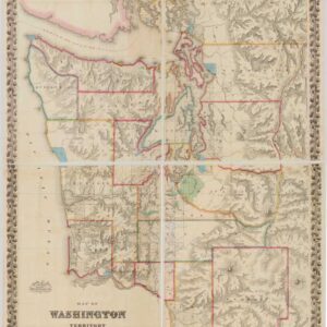
Map of Washington Territory West of the Cascade Mountains.
- The first large-format map of Washington Territory.
- Read moreQuick View
-