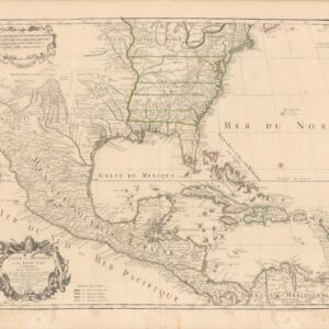
Seale’s 1745 North America with Island of California and other cartographic myths.
A Map of North America with the European Settlements & Whatever Else Is Remarkable in ye West Indies, from the Latest and Best Observations
Out of stock
Description
Cartographic myths and much else of interest fill this map of North America. It is one of the last maps to show the island of California although Seale also incorporated some information from Kino in the southwest.
Seale continues to portray fanciful details from Baron Lahontan’s romantic tale of his 1688-90 travels west of the upper Mississippi River with the Longue River stretching to the Rocky Mountains. The Straits of Annian are noted, but most of the northwest is marked Parts Unknown and contains little data. Of particular note are the many Indian Towns located throughout the map.
Shading designates the trade winds with directional arrows showing the course of the winds. The routes of the Spanish galleons are marked in the Caribbean.
Cartographer(s):
Condition Description
A crisp impression on watermarked paper. Issued folding, now pressed with minor offsetting and a short archivally repaired tear in the right blank margin.
References
McLaughlin #228; Tooley (Amer) #97; Wheat (TMW) #124.