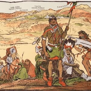
A cartographic history of Native Peoples in America, with a decorative border by Sioux artist Wounded Swallow.
A Map History of American Indian Tribes.
Out of stock
Description
This is the fascinating Second Edition of Perry C. Van Arsdale’s iconic A Map History of American Indian Tribes from 1972. It is notably different from the original in that this map derives from a hand-drawn version executed by Van Arsdale’s assistant and good friend, the Native American illustrator Wounded Swallow. Wounded Swallow, an artist belonging to the Sioux Nation, compiled this map in honor of his friend’s labors, noting in the title that it builds on 36 years of research.
The map covers all of the United States, as well as the southern parts of Canada, and includes abundant historical notes and other explanatory texts. The entire composition is framed by an elaborate border of vignettes depicting Native American designs and symbolic iconography. The map itself also abounds in information, delineating tribal areas, sketching out migratory patterns, and identifying special locations such as hunting areas, old villages, forts, springs, and skirmishes and battles. The presence of Indian Agencies alongside the plethora of dated settlements and historical confrontations all contribute to this vivacious visual demonstration of the richness of Native American history.
Wounded Swallow’s version of this wonderfully detailed map has a more nativistic feel to it than the original, in part because his hand-compilation is what was printed. The original map by Perry Van Arsdale was a two-color poster using red and black ink. This allowed for an easy visual distinction between sites associated with the U.S. government, military, or fur trading posts (inserted in black) and those locations that are associated with North America’s indigenous population. Interestingly, this second edition does not use coloring to distinguish between Native elements and those associated with the incoming population of European origin.
While the original edition of this map showed how various tribes migrated across the country in the pre-reservation period, Wounded Swallow’s map lends as much focus to the events associated with the decimation of American Indians in the 19th century. That said, it also contains ample references to internal conflicts between Native American tribes, as well as catastrophic outbreaks of disease and other calamities. Yet sadly, almost all of the information conveyed in Wounded Swallow’s poster pertains to the slow but inevitable destruction of indigenous cultures in America.
This pictorial map is a wonderful example of the thin line between cartography and art, but what makes it truly unique is the fact that it constitutes a Native American take on a European American’s take on Native Americans.
Census
The second edition of this map by Wounded Swallow was printed in 1986, probably in Kingman, Arizona. The OCLC lists only three institutional examples (no. 881237849), one of which is held by the Newbury Library in Chicago, while the two others belong to the Wisconsin Historical Society (library and archive, respectively).
Cartographer(s):
Perry C. Van Arsdale (1910-1976) was an American illustrator and pictorial mapmaker working from New Mexico and Arizona. Many of his creations dealt with the history of the United States and its indigenous populations. These have since become important pieces of cartographic Americana.
Van Arsdale served as a private in the US Army during WW2, although he is not to be confused with Sergeant Dick Van Arsdale, who participated in the Battle of the Bulge and generally played a decisive role in the Allied invasion of Normandy, Belgium, and ultimately Germany.
Wounded SwallowWounded Swallow was an artist belonging to the Sioux Nation.
Condition Description
Very good.
References
![[AMERICAN REVOLUTION] Boston, George Washington, Franklin, Philadelphia, Washington, D.C.](https://neatlinemaps.com/wp-content/uploads/2024/05/NL-02090a_thumbnail-300x300.jpg)