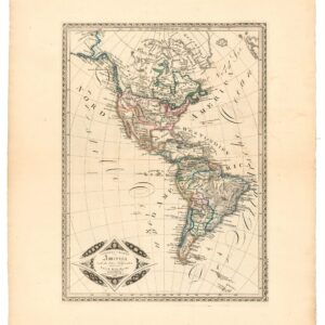
1842 French map of North America with Independent Texas and Russian Alaska.
Carte de L’Amerique Septentrionale…
Out of stock
Description
This vintage 1842 map presents North America before the Mexican-American War. It is particularly noteworthy for depicting Texas as an independent republic, which it was from 1836 to 1846. The map is drawn with the characteristic cartographic style of the mid-19th century, featuring hand-colored regions in outline. It was published in Paris, reflecting European interest in the geopolitical landscape of North America during this era.
Political boundaries are delineated, with the Republic of Texas set apart from the United States and Mexico, emphasizing its then-current status as a sovereign nation. The map includes topographical features such as mountain ranges, rivers, and valleys, and names of various territories, states.
Alaska is still part of Russia, and an inset in the lower left corner provides a more detailed view of the Aleutian Islands.
Such a map would have been an important document during a time of significant territorial changes and conflicts in North America.
Cartographer(s):
Alexandre Emile Lapie was a commercial mapmaker based in Paris in the first half of the 19th century.
Condition Description
Scattered foxing.
References
![[With Independent Texas] Mappemonde en deux hémisphères.](https://neatlinemaps.com/wp-content/uploads/2024/05/NL-02089_thumbnail-300x300.jpg)