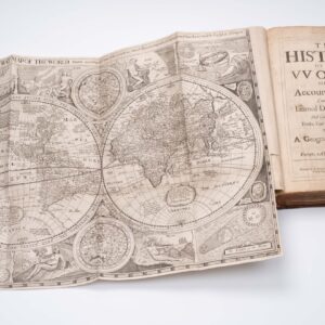
Pieter van der Keere’s iconic Germania Inferior atlas in rich original color.
[Leo Belgicus] Germania Inferior id est, XVII provinciarum ejus novae et exactae tabulae geographicae, cum Luculentis Singularum additais…1622.
$34,500
1 in stock
Description
The First Folio Atlas of the Low Countries — with the Famed Leo Belgicus Map.
This remarkable and historically significant folio was the first dedicated atlas of the Low Countries, which were struggling to throw off the yoke of Spanish supremacy and establish an independent republic at the time.
The atlas was compiled by Petrus Kaerius (a.k.a. Pieter van den Keere), one of the most skilled Flemish engravers and cartographers of the early 17th century. Kaerius was known throughout Europe for his ability to merge impeccable accuracy and detail with profound artistic expression. Consequently, his maps and engravings were in high demand by leading European mapmakers and publishers, including John Speed in England.
Kaerius’ iconic atlas was first published in 1617. Neatline’s example is the second Latin edition from 1622. The atlas was the first folio atlas exclusively devoted to the Seventeen Provinces of the Low Countries, a region that corresponds to present-day Belgium, the Netherlands, Luxembourg, and parts of northern France. In many ways, it was a revolutionary publication loaded with political dissent.
For the second edition, from 1622, Kaerius began a new collaboration with Petrus Montanus (Pieter van den Berghe), a Ghent-born scholar who was also his brother-in-law. Montanus was tasked with writing the accompanying text for the maps, which was entirely reset for this edition to reflect updated geographical knowledge and political realities.
Leo Belgicus: A Symbol of National Pride
The early 17th century was a period of intense conflict and shifting national identities within Europe, particularly in the Low Countries. The Seventeen Provinces were a battleground of the Eighty Years’ War (1568-1648), where the Dutch fought for independence from Spanish rule. This atlas, created during a period of burgeoning national consciousness, reflects the region’s political struggles and growing self-identity.
The atlas is perhaps most known for including the famous Leo Belgicus map, one of this era’s most iconic cartographic representations of the Low Countries. The map depicts the region in the shape of a rampant lion, symbolizing strength, unity, and resistance against what was perceived as foreign domination. This was not the first of such representations. Various cartographers had used the Leo Belgicus motif since the late 16th century. However, the variant published in this atlas is particularly significant as it constitutes the second state of a map engraved by Hendrik van Langren (1573-1609).
The choice of the lion as a symbol was, of course, not an arbitrary one. In addition to a general regal symbolism associated with lions, the motif had deep roots in the heraldry of the Low Countries. Most of the coats-of-arms of the Seventeen Provinces featured a lion, and the map’s design cleverly exploited the leonine shape of the region.
While the Leo Belgicus was not a unique concept at this stage, the version included in Kaerius’ atlas is particularly ornamental. In addition to the splendid old coloring and the vivaciousness of the rampant lion figure (note its awe-inspiring paws!), the map also sports three couples in the traditional garbs of Friesland, Holland, and Belgium, respectively. These figures underscore this region’s political and cultural unity against the Spanish Habsburgs.
Overall, the Germania Inferior atlas is not just a collection of maps but an important historical artifact that encapsulates the political, social, and artistic zeitgeist of the Low Countries during a period of intense transformation. The inclusion of the Leo Belgicus map, with its powerful symbolism and intricate design, alongside the detailed and carefully crafted maps of the Seventeen Provinces, makes this atlas a cornerstone of European cartography and a testament to the enduring legacy of Petrus Kaerius and his collaborators.
Census
The 1622 edition of the atlas consists of 24 double-paged maps, each adorned with decorative cartouches, small-town views, and detailed depictions of local customs. The title page is a masterpiece, finely engraved with symbolic representations of the arts of printing and navigation and surrounded by the coats of arms of each Seventeen Provinces. A skull on a sundial serves as a traditional vanitas motif, reminding readers of the transience of life and the futility of earthly pursuits.
Among the 24 maps, the Caerte van ‘t Vrije (Map of the free […]) by Claes Janszoon Visscher replaced the earlier Flandriae pars orientalior, used in the first edition. This change reflects General Kaerius’ insistence that an atlas representing the Low Countries’ struggle for autonomy must be continually revised and improved to reflect conditions on the ground. Thus, while some maps were replaced, others were moved around. An example is the map Typus Frisiae orientalis, which in the second edition had been endowed with text on the verso and moved to the end of the atlas. When Kaerius, some years later, faced financial difficulties, he sold the copper plates to Claes Janszoon Visscher, ensuring the continued influence of his work on Dutch cartography.
Original copies of the atlas, especially those with rich original hand-coloring, are exceedingly rare. Most surviving examples have been subject to modern hand-coloring, making genuine hand-colored copies highly sought after by collectors.
Context is Everything
In the 16th century, the Low Countries, comprising what is now Belgium, the Netherlands, Luxembourg, and parts of northern France, fell under Spanish control due to the complex web of European dynastic politics. The region had been part of the Habsburg Empire since the early 1500s, following the marriage of Maximilian I of Austria to Mary of Burgundy in 1477. Their grandson, Charles V, inherited the Burgundian lands, including the Low Countries, and later became both Holy Roman Emperor and King of Spain. When Charles V abdicated in 1555, he passed control of the Low Countries to his son, Philip II of Spain. Philip, a staunch Catholic, sought to impose a centralized, absolutist rule, enforcing strict religious uniformity in a region known for its economic prosperity, local autonomy, and predominantly Protestant population.
The Low Countries had a strong tradition of self-governance and religious tolerance, and this clashed sharply with Philip II’s policies. The introduction of the Spanish Inquisition and the persecution of Protestants sparked widespread unrest. This tension culminated in the outbreak of the Eighty Years’ War in 1568, a protracted conflict between the Spanish crown and Dutch rebels determined to resist Spanish domination. The northern provinces, under the leadership of William of Orange, united in their struggle for independence, while the southern provinces, which remained predominantly Catholic, continued to support Spanish rule.
As the war dragged on, the northern provinces took significant steps towards establishing an independent republic. In 1579, they formed the Union of Utrecht, a military alliance that laid the foundation for what would become the Dutch Republic. Two years later, in 1581, they formally declared independence from Spain through the Act of Abjuration, rejecting Philip II as their sovereign. This declaration marked a pivotal moment in European history, as the Dutch Republic emerged as one of the first modern nation-states founded on principles of republicanism and religious freedom.
Despite their declaration of independence, it took several decades of conflict before Spain officially recognized the sovereignty of the Dutch Republic. The occasion was the Treaty of Westphalia, which in 1648 ended the Thirty Year War between Protestants and Catholics in Europe. At a more localized level, the treaty also ended the Eighty Years’ War and forced Spain to abandon control of the Netherlands. This victory not only secured autonomy for the northern provinces but established the Dutch Republic as a significant European power, on par with any other European regime regarding its mercantile, cultural, and political achievements.
Cartographer(s):
Petrus Kaerius, also known as Pieter van den Keere (1571–c. 1646), was a prominent Flemish engraver, cartographer, and publisher crucial in developing early modern cartography. Born in Ghent, Kaerius came from a family deeply embedded in the world of printmaking and mapmaking. He trained under his brother-in-law, the famed cartographer Jodocus Hondius, in Amsterdam, where he honed his engraving and map design skills. Kaerius became known for his detailed and decorative maps, celebrated for their precision and artistry. His work was highly sought after by map publishers across Europe, and he contributed to numerous atlases, including those by the English mapmaker John Speed.
One of Kaerius’ most significant contributions to cartography was the creation of the “Germania Inferior” atlas, the first folio atlas dedicated exclusively to the Low Countries, published in 1617. This work, which included the famous Leo Belgicus map, was a testament to his craftsmanship and deep knowledge of the region. The atlas was reissued in several editions, with the 1622 Latin edition particularly notable. Despite facing financial difficulties later in life, which led to selling his copper plates to Claes Janszoon Visscher, Kaerius’ legacy endured through his maps, which remain prized by collectors and historians for their historical significance and artistic merit.
Condition Description
Tall folio. Full 18th-century vellum, morocco spine label (chipped). Light to moderate wear to binding extremities. Old dampstaining to margins of many leaves. Typographic half title with older paper reinforcement to verso of leaf along bottom margin. Similar older paper reinforcement along lower margin of left-hand leaf of "Artesia" map. Many leaves with expert paper restoration (Japanese tissue on versos of sheets), including to the verso of the Leo Belgicus map. Similar paper stabilization treatments to the versos of most of the hand-colored maps and views. A few of the maps with expert paper restoration at lower gutter fold area. The maps expertly re-tabbed.
Withal, a good example with nice original hand color. [Half-Title], [Title], [iv], 1-94 [with 25 engraved double-page maps and plates], [4] pages. Final page blank.
References
Van der Krogt. Koeman's Atlantes Neerlandici Volume IIIB 364: 02.