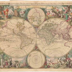
Münster’s New Map of the World.
Das erst general-inhaltend die Beschreibung und den cirkel des ganzen erdereichs und märes.
$1,600
1 in stock
Description
A groundbreaking woodblock world map that included the recently discovered American continents. The map helped reshape the European understanding of global geography, making it a significant milestone in cartographic history.
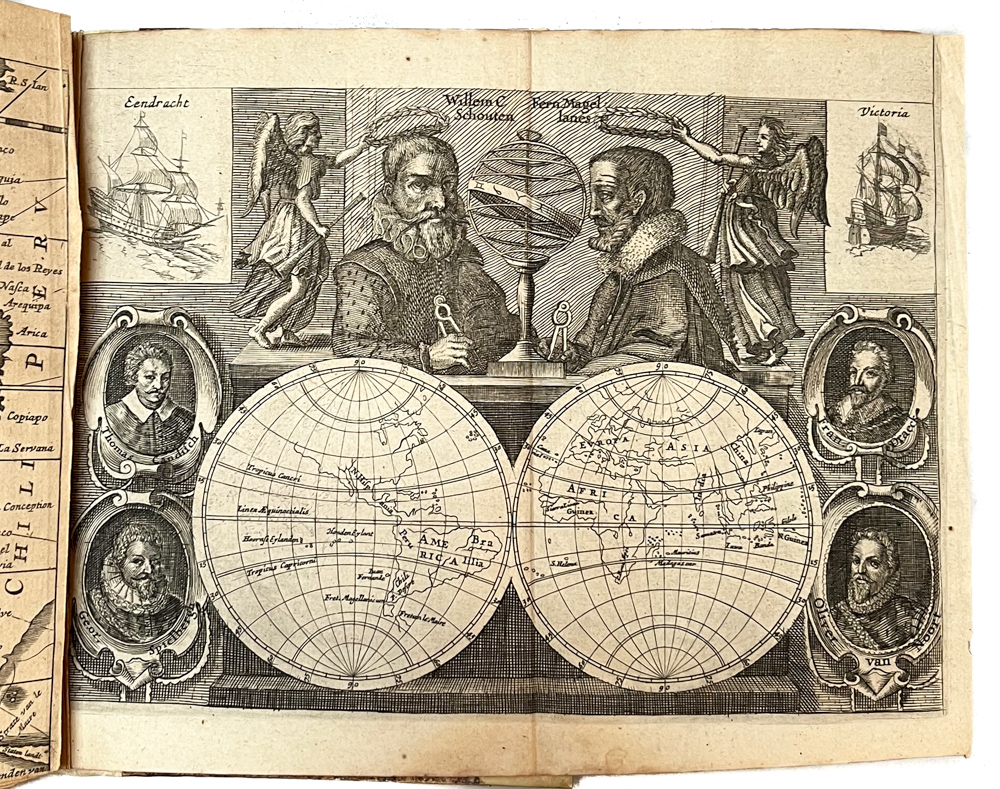
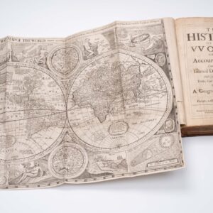
The map comes from Sebastian Münster’s most famous work, the Cosmographia, which was first published in 1544. The Cosmographia was one of the most comprehensive and widely read geographical works of the 16th century. It remained popular for decades after its initial publication.
Münster’s individual map sheets were often combined with others in the Cosmographia, and this map is no exception. Ideally, it should be viewed alongside the Ptolemaic world map, which is included in the same volume and represents the world as understood by Ptolemy. Comparing the two maps highlights the rapid progress in geographical knowledge during the 16th century.
Münster’s work played a crucial role in disseminating geographical knowledge during the Renaissance, leaving a lasting impact on cartography. Due to its immense popularity, the Cosmographia was regularly updated and reprinted, with new editions in German, French, and Italian. These translations made it a valuable resource for scholars, explorers, and geographers.
This map, though still rooted in Ptolemaic principles, incorporates the discovery and mapping of the New World. It depicts the known continents of Europe, Asia, and Africa while also offering an early and relatively schematic representation of the Americas.
Accuracy and Myth in Münster’s Map
Despite his updates, Münster retained some Ptolemaic traditions, resulting in inaccuracies and mythical elements. One example, common in maps based on Ptolemy, is the exaggerated depiction of Taprobana (modern-day Sri Lanka). This misrepresentation dates back to Classical Antiquity, when Roman traders sailed directly to Sri Lanka from Egyptian Red Sea ports.
A distinctive feature of Münster’s cartography is the inclusion of fantastical creatures. In this map, as in many of his works, mythical sea monsters lurk in the vast, uncharted oceans that were being explored and dominated by Europe’s maritime powers. These elements reflect both the Renaissance fascination with the unknown and the artistic traditions of medieval mapmaking.
This stunning woodblock print offers a captivating glimpse into how global geography was understood nearly five centuries ago. It invites us to explore the thrilling and sometimes terrifying world of the Late Renaissance, demonstrating how perceptions of our planet have evolved dramatically over time.
Publication information
The Neatline edition of this map was printed from the second woodblock created for Münster’s Cosmographia, making it the second state of the map (Shirley 92). The original state was first issued in the 1540 edition and reprinted in 1541, 1542, and 1545 (all in Latin).
For the 1550 edition, a new woodblock was carved by David Kandel (c. 1520–1592), who signed the block in the lower-left corner of the map. A key difference in this edition was the repositioning of the eastern and western wind heads outside the map oval. The second block was used for all Basel editions of the Cosmographia between 1550 and 1587. A third woodblock was created for the 1588 edition.
The Neatline example of this remarkable map comes from the 1567 German edition of the Cosmographia, published in Basel by Henrich Petri. German editions of the second state were published in 1550, 1553, 1556, 1558, 1561, 1567, 1569, 1572, 1574, and 1578.
Cartographer(s):
Sebastian Münster (1488-1552) was a cosmographer and professor of Hebrew who taught at Tübingen, Heidelberg, and Basel. He settled in Basel in 1529 and died there, of the plague, in 1552. Münster was a networking specialist and stood at the center of a large network of scholars from whom he obtained geographic descriptions, maps, and directions.
As a young man, Münster joined the Franciscan order, in which he became a priest. He studied geography at Tübingen, graduating in 1518. Shortly thereafter, he moved to Basel for the first time, where he published a Hebrew grammar, one of the first books in Hebrew published in Germany. In 1521, Münster moved to Heidelberg, where he continued to publish Hebrew texts and the first German books in Aramaic. After converting to Protestantism in 1529, he took over the chair of Hebrew at Basel, where he published his main Hebrew work, a two-volume Old Testament with a Latin translation.
Münster published his first known map, a map of Germany, in 1525. Three years later, he released a treatise on sundials. But it would not be until 1540 that he published his first cartographic tour de force: the Geographia universalis vetus et nova, an updated edition of Ptolemy’s Geography. In addition to the Ptolemaic maps, Münster added 21 modern maps. Among Münster’s innovations was the inclusion of map for each continent, a concept that would influence Abraham Ortelius and other early atlas makers in the decades to come. The Geographia was reprinted in 1542, 1545, and 1552.
Münster’s masterpiece was nevertheless his Cosmographia universalis. First published in 1544, the book was reissued in at least 35 editions by 1628. It was the first German-language description of the world and contained 471 woodcuts and 26 maps over six volumes. The Cosmographia was widely used in the sixteenth and seventeenth centuries and many of its maps were adopted and modified over time, making Münster an influential cornerstone of geographical thought for generations.
Condition Description
Hand color. Visible repairs, as seen on the image. Overall nice.
References