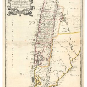
Hand-colored 1747 Bowen map with insets of Santiago and Tierra del Fuego
A New and Accurate Map of Chili, Terra Magellanica, Terra del Fuego &c. Laid down according to the latest improvements and regulated by astron.l observat.ns.
Out of stock
Description
Bowen’s map of the southern part of South America from A Complete System of Geography. Includes many place names, much topographical detail, and a number of notations that provide additional geographical and historical information.
An inset of a city plan for Santiago, capital of Chile, contains a legend listing significant buildings and locations, and a second inset details the area around Terra del Fuego and traces the tracks of several explorations.
Cartographer(s):
Emanuel Bowen (1694-1767) was a British engraver, map-maker, and print seller, who was particularly well-known for his atlases and county maps. Bowen was widely acknowledged for his geographic expertise, and he was appointed as the official cartographer to both George II of England and Louis XV of France. Despite these appointments and the general acknowledgment, Bowen still died in poverty. Following his death, his London business passed to his son Thomas Bowen, who also seems to have struck on hard luck. Several of Emanuel Bowen’s apprentices would rise to fame after his death, including the illustrious English mapmakers Thomas Jeffreys and Thomas Kitchin.
Condition Description
Left margin trimmed, with some soiling. Minor foxing.
References

![[Vietnamese Maps of North America: Mexico, Canada, USA]](https://neatlinemaps.com/wp-content/uploads/2022/04/NL-01262-USA_thumbnail-scaled-300x300.jpg)