Rare first edition of Lahontan’s description and mapping of New France, which propagated the myth of the Northwest Passage.
Nouveaux Voyages de Mr. Le Baron de Lahontan Dans L’Amerique Septentrionale, Qui contiennent une relation…
Out of stock
Description
Complete first edition, rarely seen on the market — a true collector’s item!
The maps, which are first states, are described as follows:
1. Carte que les Gnacsitares ont Dessiné sur… Carte de la Rivière Longue et de quelques autres qui se Déchargent dans le Grand Fleuve Mississippi…
A fascinating and very significant rare map that influenced a generation of some of the most important cartographers of the 18th century including Guillaume de l’Isle and John Senex, and their depictions of the American Northwest. The intriguing map is a composite of two depictions. The first draws a fictitious “Rivière Longue” emanating from the Great Lakes region and the Mississippi, while the second is a depiction of the “Rivière Morte” that was claimed to have been drawn from reports by the Gnacsitares tribe. This latter river system emanated from a Western mountain range, which we now know as the Rocky Mountains and was linked to another river system on its Western side in the region of the “Pais des Mozeemlek.”
That it is a first state can be discerned by the omission of a longitudinal scale at the top of the map.
Lahontan’s map was influential because it provided the possibility of an internal river route to the Pacific from the Great Lakes region. Lahontan’s depictions of the “Rivière Longue” and the “Rivière Morte,” which eventually became known as the “River of the West” with its various fanciful drawings, might be pure fabrications on the part of Lahontan.
His map is adorned with different markings showing his route to the interior from the French outpost of Misilimakinak as well as displaying the different French trade outposts and forts near Lake Superior and Lake des Illinois (Michigan) and Native tribes such as the Mozeemlek, the Gnacsitares, the Tahuglauks, the Esanapes, the Eokors who were supposedly located on Lahontan’s fictitious rivers. Also added by Lahontan are drawings of lodgings and canoes of the Tahuglauk tribe and their copper medals.
However, it is conceivable that Lahontan’s depictions were not entirely fabrications and were actually the result of his discovery, or (more likely) his access to native reports of the Missouri River. It should be noted that Lahontan is basing his recollections on actual travels to the upper Mississippi River valley in 1688 whilst leading French forces in their conflicts with the Iroquois Nations. As such, native claims of the Missouri River, the longest river in North America which does in fact begin in the Rocky Mountains in Montana and does flow east into the Mississippi north of St. Louis, Missouri, could have come to his attention.
Lahontan’s map should therefore be seen not only as possibly a fanciful depiction that influenced the cartography of the Northwest, but also as a potential first impression of the Missouri, America’s longest river.
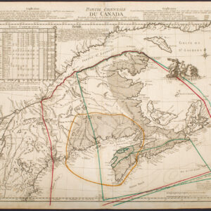
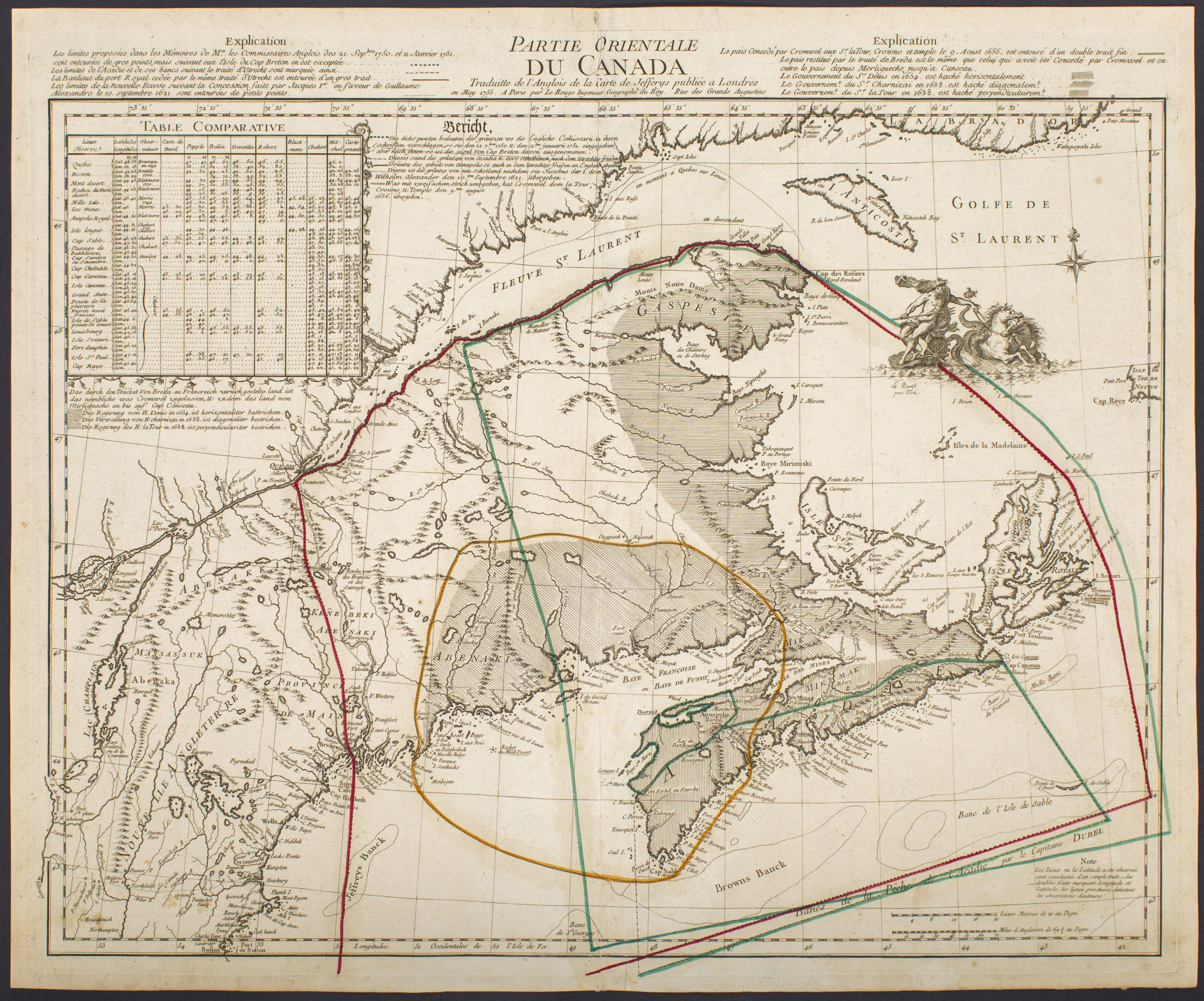
2. Carte Generale De Canada. Dediee au Roy de Danemark Par son tres humble et tres obeissant et tres fidele serviteur Lahontan.
Centered on the Great Lakes, this map extends from from Acadia and the mouth of the St. Lawrence, to the upper Mississippi River and the Grand Lac des Assinipoval. A number of forts and towns are identified, including Boston, Manhattan (Manate) but without Long Island, Montreal, Quebec (Kebek), and Chicago (Chegakou). Portages between rivers are marked with a Maltese cross and the Indian Villages that were destroyed by the Iroquois are marked by a shield with three dots. A dashed line extending across the map indicates the “limits of Canada per the French” and a note below indicates that this boundary also served as the route that various Indian tribes used to wage war with the Iroquois.
Cartographer(s):
In the 17th century, France laid claim to a vast territory in the Americas. In the 1530s Jacques Cartier claimed Canada for France and had explored the Gulf of Saint Lawrence and the Saint Lawrence River. By the 1580s, the French were trading in furs up the Saint Lawrence River, and in 1682, La Salle had explored the Ohio and Mississippi River valleys, laying claim to the vast Louisiana Territory—mostly the Mississippi Valley—for France.
The next year, 1683, Louis Armand, Baron de Lahontan, age 17, arrived in New France as an officer in the French troupe des marines. Over the next 9 years, he traveled extensively, often leading troops in combat against native peoples. He had an inquisitive spirit, which led to his learning Algonquian, and exploring the land in which he lived. In 1687 and 1688, he led troops in the Iroquois Wars, and commanded the Fort St. Joseph (now Port Huron, Michigan) at the southern tip of Lake Huron. In the summer of 1688, knowing that he would receive no supplies to support his command, he burned the fort, and led his men to Michillimackinac—the strait joining Lakes Huron and Michigan—where he hoped to find supplies. During that winter and the following spring, Lahontan explored extensively in the region and to the south in the upper Mississippi valley. Lahontan served until 1692, when, after a conflict with the governor, he deserted service and found passage to Portugal.
Lahontan was an explorer in the sense that he was the first European to travel in certain areas of the North American continent, but his explorations were in lands already claimed by France due to the explorations of La Salle some years earlier. Lahontan’s travels are best known because of his books. In 1703, unable return to France for having deserted service in New France, he was living in Amsterdam, where he published the two volumes of his book New Voyages in North America [Nouveaux Voyages de Mr. Le Baron de Lahontan Dans L’Amerique Septentrionale].
This book was extremely popular and influential in its day—over 20 editions were published from 1703 to the 1740s, including English, Dutch, and German editions, as well as the original French—and is still recognized as perhaps the best seventeenth century book on New France, despite some parts that may be fabrication. It contains extensive descriptions of his exploration of the land, including beaver hunting grounds, portages, French forts, and native and Jesuit settlements. In addition to its descriptions of America, the New Voyages to North America include an extensive political and philosophical dialogue that contains one of major early 18th-century exemplars of the “noble savage,” in the character of one Adario [i.e., “the Rat,” based on the real Huron chief Kondiaronk], a supposed Huron chief, who debates with the character Lahontan on a range of religious, philosophical, and political issues in the course of the four dialogues included in the second volume.
One of his most notable discoveries was La Rivière Longue, which was possibly the Missouri River valley, or was possibly no more than a fiction. As described in more detail below, this idea would have an enormous and lasting impact on the European cartographic representations of North America for nearly a century to follow.
Condition Description
2 vols. 2 pp. Frontis., [22]. 279 pp., two maps (one folding), 12 folding plates; 2 pp. Frontis., 220, [17] pp. + folding map, 10 folding plates. 12mo. Old speckled calf. Spines rebacked with modern calf in a contrasting color, raised bands and gilt lettered labels. First edition, first issue with the angel emblem on the title page of both volumes. Each volume: 10.7 x 16.5 cm (4.2 x 6.5 in); Carte Generale de Canada: 53.3 x 43.2 cm (21 x 17 in); Carte de la Riviere Longue: 66 x 29.2 cm (26 x 11. 5 in) Volume 1: Text generally clean with occasional foxing. The large Carte Generale du Canada has some stains, mostly at upper right where it touched a text page; the right margin is trimmed close where fitted into the book with a two inch fold tear and some creasing. The plate facing p. 242 creased with a small tear where folded into the book. Volume 2: Some creasing to large Riviere Longue map; minor transference; Plate facing p. 133 small tear where folded into book; lower corner of leaf C12 lacking, text not affected.
References
Kershaw 299-306, Mapp, P., The Elusive West and the contest for Empire, 2011. Howes L25; Karpinski p. 127; Kershaw #282, #289, #298; McCorkle 703.3, 703.4; Wheat #86.