Willem Schouten’s journal of the famous 1615-7 Le Maire-Schouten expedition, one of history’s greatest voyages of discovery.
Diarium vel Descriptio laboriosissimi, & molestissimi Itineris, factia Guilielmo Cornelli Schoutenio, Hornano. Annis 1615, 1616 & 1617.
$6,200
1 in stock
Description
This is Vlasbloem’s 1662 publication of Willem Corneliszoon Schouten’s account of his consequential 1615-7 voyage of discovery. The expedition sought to find a new route to the Pacific and the Spice Islands, in order to avoid the trading monopoly of the Dutch East India Company and find the Southern Continent (Terra Australis). Schouten led the expedition with Jacques Le Maire. It was chartered by Jacques’ father, Issac Le Maire, a founder of the Australian Company.
The expedition remains one of history’s most important voyages of exploration, rounding (and naming) Cape Horn for the first time, and discovering the Strait of Le Maire, Staten Island, some of the Friendly Islands (Tonga Islands). Both Schouten and Le Maire wrote journals during the voyage, but the two navigators were imprisoned by regional Dutch East India Company governor Jan Pieterszoon Coen when when they reached Batavia. Le Maire died shortly after being released, and thus Schouten was the first to publish his version of the circumnavigation, in 1618.
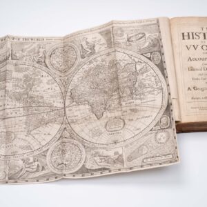
The example offered here is complete: 71 pages of text, two fold-out maps, one fold-out plan, and four fold-out views. It constitutes Vlasbloem’s 3rd edition from 1662; both the first and second editions were published in 1648, and all three are extremely rare. It contains two maps:
1. The South Sea map showing Schouten and Le Maire’s route across the Pacific Ocean from Cape Horn on the ship Eendracht. This important map is often missing; Sabin states that: “The map of the South Sea is evidently not included in the plate numbers on page 71 and is probably lacking in some copies. There is no doubt however of its belonging to the book.”
2. A simple double hemisphere world map notable for its portraits of famous navigators, including of course Schouten himself, along with Magellan, Drake, Von Noort, Cavendish, and Speilbergen. Schouten’s ship is depicted opposite Magellan’s Victoria, drawing a clear parallel between the two voyages of discovery.
Another engraving depicts Port Desire (today’s Puerto Deseado in Patagonia), where the expedition stopped for repairs in December 1615, and where it lost one of its two ships to fire. The remaining views depict scenes from the expedition.
Context is everything
Willem Schouten’s journey is undoubtedly among the greatest Dutch expeditions launched during the Age of Exploration. But more than that, it stands as one of the most seminal accomplishments in early navigation, being the first expedition to avoid the Magellan Strait, instead rounding the treacherous Cape Horn. The feat was originally not about making navigational history but was rather a way of avoiding the Dutch East India Company’s monopoly on international trade.
Willem Schouten was the expedition’s navigator and, consequently, the man responsible for charting a survivable course into the great unknown. The prominent Dutch merchant had selected him, Isaac Le Maire (1558–1624), to accompany his son, Jacques, on this fateful expedition, whose primary goal was to establish new trade beyond the reach of the powerful VOC (Dutch East India Company).
In 1602, the nascent Dutch government granted the newly established VOC a strict monopoly on trade with the East Indies, which was quickly making the newly autonomous Holland overtly wealthy. But Dutch merchants and seamen had struggled for generations to cast off the yoke of Spanish dominion, and in the light of their newly won freedom, the VOC’s monopoly soon began rubbing certain quarters the wrong way. Among the first to challenge the VOC monopoly was Isaac Le Maire, who himself was a major stockholder in the company. Demanding the right to explore freely and to reap the mercantile potential profits that such explorations might yield, Le Maire created a new trading company in 1610, which he named the Australian Company. Using his extensive influence in the legislature and government, he secured independent rights to trade with China, Japan, Korea, New Holland (Australia), and the South Pacific islands.
Mounting his company’s first expedition soon after, Le Maire put his son Jacques in charge of the expedition and hired Willem Schouten as its navigator. The men were to take two ships, the Eendracht and the Hoorn, and sail them across the Atlantic and the Pacific to find new trading opportunities in the Far East. Leaving Holland in the summer of 1615, the two ships sailed south along the African coastline before turning West to follow the old Portuguese route to Brazil. Having successfully accomplished their first oceanic crossing, the expedition rested and resupplied in Patagonia for about a month. During this time, the Hoorn was ominously lost to fire. Undeterred, the expedition continued its journey south to reach Cape Horn. Sailing around the entire continent had not been done before, but it was crucial since the VOC fully controlled the much safer Strait of Magellan. No Dutch ship could pass this or the Cape of Good Hope without explicit permission.
Passing the mouth of the Strait in late January of 1616, Schouten ordered the ship to tack into the strong winds and violent seas. Saling back and forth in horrible cold weather, the Eendracht finally passed Cape Horn on the last day of January 1616. In front of them lay the endlessness of the Pacific. Schouten set a west-to-northwest course, soon broaching the largest empty frontier on the planet. The crossing was not uneventful. Schouten and Le Maire identified and named several Pacific island clusters, including part of what is now the Tuamotu Archipelago and the islands of Tonga and Futuna, the latter of which they named after the Hoorn (both the ship and the feature). From here, the expedition headed north to the Moluccas, which were well-known to European traders as the Spice Islands at the time.
After having successfully traded with various groups in the Indonesian Archipelago, the ship finally arrived at the emergent Dutch colony of Jayakarta on the island of Java. Within a few years (1619), the Dutch would rebuild and rename this ancient city to become Batavia, the crown jewel of Holland’s colonial empire in Asia. The VOC was at the head of these developments and quickly made Batavia their international headquarters. But even in 1616, the VOC sustained a significant presence here and could exercise their power unabated. Not fully understanding what Le Maire and Scouten had accomplished, the regional governor, Jan Pieterszoon Coen (1587–1629), ordered the Eendracht and its cargo seized on the basis that the ship had violated the rights of the VOC. Any objections would have to be settled back in Holland. The crew were then forcefully put on VOC ships and sent home.
While Le Maire sadly died en route, Schouten arrived in Holland in the summer of 1617 and immediately launched a legal case against the seizure. It took almost five years to complete and would not have been possible without the financial backing and moral support of Isaac Le Maire, who had come up with the idea in the first place, and who had lost his son to it. In 1622, the courts ruled in favor of Le Maire and Schouten, forcing the VOC to compensate them for both ship and cargo. Once the case had been settled, Isaac, by now in his mid-60s, made sure that the diaries and logs of his son’s expedition were published so that his name would be etched onto the pages of history. Yet despite Isaac Le Maire’s efforts to legitimize and disseminate the expedition’s accomplishments, the story of Holland’s greatest Pacific venture remains one of the lesser-known milestones in the history of exploration.
Cartographer(s):
Louis Vlasbloem was an influential publisher active in Amsterdam during the second half of the 17th century.
Willem Corneliszoon SchoutenWillem Cornelisz Schouten (c. 1567 – 1625) was a Dutch navigator for the Dutch East India Company. He was the first to sail the Cape Horn route to the Pacific Ocean.
Condition Description
Excellent. Minor staining. Maps clean and intact. In small quarto, 19th century binding. 4 nn leaves. 71 pages, collation complete.
Dimensions:
Book: 13 x 18 cm (5.1 x 7 in)
South Sea map: 39 x 18 (15.4 x 7 in)
World map: 22 x 18 cm (8.7 x 7 in)
References
Sabin 77961.