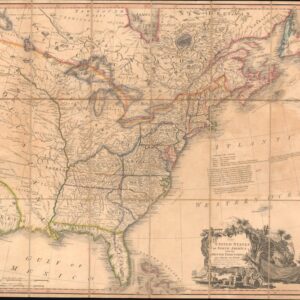
A French map of the United States, updated to include the Republic of Texas and the city of Austin.
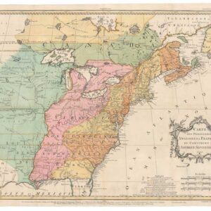
Carte Générale des États-Unis, des Haut et Bas-Canada, de la Nouvelle Ecosse, du Nouveau Brunswick, de Terre-Neuve, etc.
Out of stock
Description
This fascinating and highly-detailed map outlines the territorial claims of no less than five different state and monarchical powers, including the Republic of Texas. The map shows an area stretching from the East Coast (with insets of Newfoundland and south Florida in order to fit the publication format) as far west as the 102 meridian west. Today this meridian passes through the Dakotas, Nebraska, Kansas, Oklahoma, and Texas, but in 1843, when this map was published, much of this area was the western frontier, and the map delineates broad swathes of Indian territory, including the Osages.
Above all, what we find interesting about this map is that these are the last years when there are so many different countries vying for power within what would become the United States, a time when borders were still much in flux. The legend delineates the claims of 1) the United States; 2) the Republic of Texas; 3) the English Crown; 4) Mexico; 5) the French Crown (this refers to Louis Philippe I – the monarchy would be abolished 5 years later).
The Republic of Texas was a sovereign state that existed from March 2, 1836, to February 19, 1846. This map has been updated from an earlier edition to reflect this momentous turn-of-events. These updates include the Republic’s inclusion in the legend and colored border on the map, but also the addition of the city of Austin, which has been squeezed somewhat awkwardly between lines of text in central Texas.
This is the United States in the years before its last great territorial expansion, which came with its victory in the Mexican-American War. We see that its current borders were not a fait accompli, even at this relatively late stage. Imagine how different history would be if Texas had remained independent or been reconquered by Mexico, or if Britain had established itself further in the West, not to mention if American Indians had been given more say.
Cartographer(s):
Adrien Hubert Brué (1786-1832) was a French cartographer active in the 18th and 19th centuries. He was born in Paris on March 20, 1786, and died of cholera on July 16, 1832, in Sceaux.
In his youth, Brué served as a cabin boy on various ships, including aboard the Naturaliste, which was part of the Baudin expedition (1800-1804) to the South Seas and New Holland (Australia). Upon his return, he began producing maps for a grand atlas, published for the first time in 1820. A new and better atlas was issued in 1830, the same year he was appointed Royal Geographer.
Brué’s production included various atlases and unique maps, all of which were recognized for the purity of the engraving and the accuracy of the information. His main work, the Atlas universel was expanded multiple by him and Charles Picquet (whose stamp is found on most of Brué’s maps). Among the many aspects that elevated Brué above his peers was the. The fact that he drew his maps directly onto copper plates, a process which he named cartel end prototypes.
Charles PicquetCharles Picquet (1771-1821) was a French cartographer especially celebrated for his collaborations with Adrien-Hubert Brué.
Condition Description
Minor offsetting. Excellent.
References
OCLC 727082385. Wheat, C. I., Mapping of the Transmississippi West, 1540 – 1861, #420. Rumsey 2741.059.
![[AMERICAN REVOLUTION] Boston, George Washington, Franklin, Philadelphia, Washington, D.C.](https://neatlinemaps.com/wp-content/uploads/2024/05/NL-02090a_thumbnail-300x300.jpg)