With Two Early San Francisco Maps and Interesting Provenance.
The Manual of the Corporation of the City of San Francisco…
$8,500
1 in stock
Description
Two Maps That Defined a City’s Future.
A rare survival, this is a fine example of the 1852 Manual of the Corporation of the City of San Francisco, containing both its original maps, which are among the earliest obtainable maps of the city.
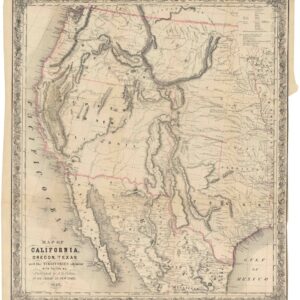
The first map, simply titled ‘Map of San Francisco,’ was printed by B.F. Butler, who had also printed City Surveyor William Eddy’s ‘Official map of the City of San Francisco’ the previous year. The present map shares much with Eddy’s 1851 ‘Red Line’ map, including the numbering of wards, blocks, and lots, the tracing of the original water line, and the inclusion of planned lots on areas of future landfill. But it differs in orientation, appearing here with west instead of north at the top. Butler’s map also notes the location of nine public institutions (post office, customs house, jail, etc.) and thirteen churches, as well as marking ‘lately planked streets.’ Some other minor additions are evident, such as a note near the ‘Government Reserve’ at the waterfront of Washington and Jackson streets, where the government was considering the construction of a canal.
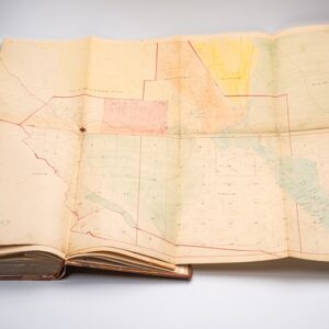
The second map, rarer and even more significant than the city map, is titled ‘Map of the Northern Portion of San Francisco County’ and dated January 1853, despite the book’s publication date being 1852. It was prepared by County of San Francisco surveyor Clement Humphreys and also printed by Butler. Humphreys is credited, and his office compiled available surveys, but the composition of the map appears to have been undertaken by Polish-born surveyor Alexander Zakreski (1799-1866), a military topographer, draughtsman, and lithographer who fled his native Poland to France and then, in 1848, to California. Zakreski is perhaps best known for producing one of the earliest maps of the city, based on Eddy’s surveys, but the present map is among the earliest and most comprehensive to depict the relationship between the growing city of San Francisco and its hinterland, still composed of ranchos. Its importance is reflected in the fact that the Board of Supervisors rushed to have the manuscript original lithographed for inclusion in the Manual of the Corporation of the City of San Francisco.
Historical Context
At this time, the County of San Francisco was larger than it is today, extending beyond San Bruno Mountain into what is now San Mateo County. At the same time, much of what is now part of the City and County of San Francisco was unincorporated ranchland, while the city was confined to the modern city’s northeast corner (the city lines of 1850 and 1851 are both labeled here). The various ranchos around the city are labeled, vara sizes are with their property lines traced and owners and sizes documented, along with some smaller properties whose size in varas is noted. The collection of military buildings in the Presidio, along with several paths and roads, a nearby telegraph office, Mission Delores, and an abbey in the vicinity of today’s Balboa Park, and multiple lagunas are also recorded, along with illustrated elevation (the heights of Telegraph and Russian Hills listed) and terrain. A dashed line represents the point 2 leagues south of the Presidio. This feature, as with the map overall, is particularly important because it reflects the City of San Francisco’s already growing ambitions to claim the entire northern part of the peninsula.
Publication History and Census
The Manual of the Corporation of the City of San Francisco was published by G.K. Fitch & Co. in 1852, with both maps printed by B.F. Butler; the second map, compiled by County Surveyor Clement Humphreys and drafted by Alexander Zakreski, bears the date January 1853 despite the volume’s stated publication year.
Both of these maps and the volume are rare. In terms of institutional collections, the entire book is cataloged at fourteen institutions in the OCLC (11791173), though several of these appear to refer to digitized rather than physical examples. At the same time, the individual maps are also sometimes separately cataloged at a handful of institutions (often those also holding the book, cataloging both the book and maps for good measure).
The individual maps are sometimes sold separately from the book, but, in any event, are very rarely offered for sale. The ‘Map of the Northern Portion of San Francisco County’ has come to market occasionally in recent years, with one example being bought and resold several times among map and book dealers. However, a complete example of the Manual with both maps is exceedingly rare, with only one example appearing at market in the past forty years.
Furthermore, our example has significant provenance, having belonged to Alderman (i.e., Supervisor) C. O. West, who served on the Board of Supervisors between October 1853 and October 1854.
Cartographer(s):
Alexander Zakreski (1799-1866), was born in Poland but ran afoul with Russian authorities and was forced to flee to France. Events of the Revolution of 1848 again compelled him move on, this time to San Francisco, where he arrived in 1850.
Zakreski was a talented engineer and surveyor, skills he put to work as one of the newly booming city’s most important cartographers.
B.F. ButlerB.F. Butler was one of the leading printers and lithographers in Gold Rush-era San Francisco, active in the city’s print trade during the critical early 1850s when the demand for maps, directories, and official publications was intense. He is known to have printed Eddy’s 1851 “Red Line” map — then the most authoritative map of the city — and subsequently produced both maps included in the present Manual of the Corporation of the City of San Francisco. He later operated in partnership as Sterett & Butler, printers, engravers, and publishers at 145 Clay Street, San Francisco.
Clement HumphreysClement Humphreys served as County Surveyor of San Francisco County in the early 1850s, a period of rapid and consequential geographic change as the city strained against its original boundaries and the county’s relationship to the growing metropolis was actively being defined. His primary contribution to the second map in this volume was the compilation of available surveys of the northern portion of the county; the actual drafting and lithographic execution of the map was undertaken by Alexander Zakreski. The Board of Supervisors’ decision to rush the manuscript original to press for inclusion in the Manual reflects the political urgency attached to establishing a clear geographic record of the city’s expanding ambitions.
G.K. Fitch & Co.G.K. Fitch & Co. was the publishing imprint of George Kenyon Fitch (1826–1906), one of the most prominent figures in early California journalism and publishing. Born in New York, Fitch arrived in California in 1849 and established himself first in Sacramento, where he helped found the Sacramento Times and Transcript. By 1852 he had moved to San Francisco — precisely the moment when G.K. Fitch & Co. published the present Manual — and went on to become one of the city’s most influential press figures, eventually acquiring the San Francisco Bulletin and the San Francisco Call in partnership with Loring Pickering and James W. Simonton, both of which became powerful voices in the city.
Condition Description
8vo (21.3 x 14 cm). 2 lithographed folding maps: "Map of San Francisco" (240 x 285 mm, on tinted blue paper) and "Map of the Northern Portion of San Francisco County Compiled from Surveys June 1st 1852 by Clement Humphreys County Surveyor, January 1853" (40.8 x 51 cm), each lithographed by B.F. Butler, with a repaired closed tear to the inner margin.
Contemporary sheep, upper cover with morocco label "Asst Ald West/ 4th Ward. San Francisco," re-backed, retaining much of original spine, minor foxing throughout.
Provenance: Assistant Alderman West (morocco label); S.A. Sharp (ownership inscription).
References