Two works linked to historian George Davidson — an annotated Coast Survey chart and a proof copy of his 1887 report on early Pacific Coast exploration.
Reconnaissance of the Western Coast of the United States from San Francisco to Umpquah River [&] Voyages of Discovery and Exploration on the Northwest Coast of America from 1539 to 1603.
$2,400
1 in stock
Description
Offered here together are two rare artifacts from the career of George Davidson (1825–1911), the pioneering American geodesist, surveyor, and historian of Pacific exploration. Both reflect Davidson’s lifelong effort to merge scientific cartography with historical reconstruction, to reconcile the precise measurements of the U.S. Coast and Geodetic Survey with the fragmentary narratives of the first European explorers of the American West Coast.
The first is Davidson’s heavily annotated Coast Survey chart of Northern California and Oregon, used in his reconstruction of the 1602–03 voyages of Sebastián Vizcaíno and Martín Aguilar. The second is a scarce proof edition of his 1887 Coast and Geodetic Survey report, An Examination of Some of the Early Voyages of Discovery and Exploration on the Northwest Coast of America, inscribed by Davidson to his Berkeley colleague Professor Henry Senger.
Together, they form a remarkable intellectual pairing, a working map and its published synthesis, illuminating Davidson’s method of uniting field geography, archival research, and historical imagination.
George Davidson’s Annotated Coast Survey Chart of Northern California and Oregon.
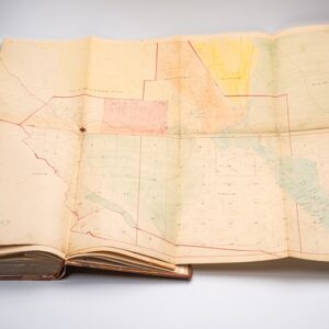
This exceptional U.S. Coast Survey chart of the Northern California and Oregon coast is heavily annotated by George Davidson, the eminent 19th-century geodesist and historian of Pacific exploration, as part of his lifelong effort to reconstruct the 1602–1603 voyages of Sebastián Vizcaíno and Martín Aguilar.
Born in England and educated in Philadelphia, Davidson joined the United States Coast Survey in 1845, beginning a five-decade career that defined early scientific geography on the American West Coast. Among his many achievements, he supervised the triangulation of California, surveyed the Yolo and Los Angeles baselines, authored the Coast Pilot of California, Oregon, and Washington (1857–1887) and the Coast Pilot of Alaska (1868), and founded the Davidson Observatory in San Francisco. After retiring from the Survey in 1895, he became the first professor of geography at the University of California, Berkeley, teaching until 1905.
Davidson’s deep expertise in coastal geography made him uniquely qualified to analyze the fragmentary narratives of early Spanish exploration. Using the logs and journals of Vizcaíno’s 1602–03 expedition, he attempted to reconcile their observations with modern hydrography, currents, and topography. His dense pencil annotations on this chart trace the probable tracks of Vizcaíno’s flagship San Diego and Aguilar’s Tres Reyes, which separated near Point Reyes and ventured as far north as present-day Oregon. Notes on coastal features, currents, and headings record Davidson’s methodical effort to match 17th-century descriptions to the known coastline.
The chart itself is a classic Coast Survey production, with intricate soundings, engraved coastal profiles, and detailed sailing directions. Davidson’s name appears in the title block as the provider of “geographical positions.” Two place names—Cape Sebastian and Cape Ferrelo—are added in his own hand, memorializing the Spanish explorers Vizcaíno and Bartolomé Ferrelo; both were later formalized in the 1869 Coast Pilot of California, Oregon, and Washington.
In his 1886 Report of the Superintendent of the U.S. Coast and Geodetic Survey, Davidson summarized this very work, describing how “with the present knowledge of our coast it is possible to locate Ulloa; to track Cabrillo and Ferrelo in their discoveries in mid-winter; to place Drake under Cape Ferrelo and Point Reyes; and to fix with certainty most of Vizcaíno’s positions.”
Following Davidson’s death, his annotated charts entered the Bancroft Library along with his papers, later partially deaccessioned and dispersed—many through the collection of Warren Heckrotte. This example, bearing Davidson’s unmistakable annotations, represents an extraordinary artifact of historical geography in action: a working document through which one of America’s great coastal surveyors sought to unite the science of his century with the voyages of the 16th and 17th.
A proof copy dedicated by Davidson to a fellow professor at the University of California.
This is a scarce proof edition of the 1887 U.S. Coast and Geodetic Survey report on the early history of exploration on the west coast of North America. The author, legendary cartographer and geodesist George Davidson, examines the records and maps produced by purported early sightings of the west coast, particularly early Spanish and some English explorers. Davidson is frank about the limitations and questionable reliability of the sources. He tries to reconstruct the voyages as best he can and assess the credibility of their claimed discoveries.
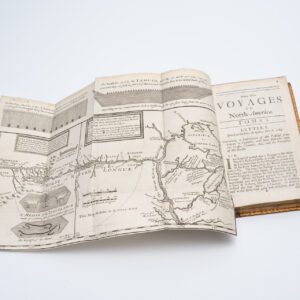
The report includes a foldout map titled ‘Landfalls of Cabrillo and Ferrelo’ on the Pacific Coast, with extensive notes on the progress of those two voyages. Davidson’s report was a significant early effort to summarize and assess early European voyages along the west coast of North America and has been highly influential on later scholarly works that reexamined these voyages.
This work was prepared by the U.S. Coast and Geodetic Survey as Appendix No. 7 to its 1886 Annual Report. It is cataloged among the holdings of about 20 institutions in the OCLC. However, this example is notable for being a proof copy with alternating blank pages, dedicated by Davidson to Professor Henry Senger, a German professor at the University of California (Berkeley). Senger, ever the professor, has made annotations, corrections, and suggestions throughout the text.
The reason a geodesist would consult a professor of German is not immediately clear, but both men were prominent professors at the University of California and served together in administrative capacities, including the University’s Academic Council. Both were also charter members of the Sierra Club and corresponded with John Muir. Therefore, it is safe to assume a sense of friendship or at least collegiality between the two men.
Conclusion
Together, these pieces offer a rare window into the mind and working methods of one of America’s greatest coastal scientists, bridging the practical world of 19th-century hydrography and the humanistic study of discovery. They embody the moment when American scientific geography reached maturity, when the precision of modern surveying was first applied to the mysteries of the Pacific’s earliest maps. As a paired offering, they represent a singular convergence of cartography, exploration history, and intellectual biography.
Cartographer(s):
George Davidson (May 9, 1825 – December 1, 1911) was a geodesist, astronomer, geographer, surveyor, and engineer in the United States.
Upon his graduation from college in 1845, he began his career as clerk to Alexander Bache who was superindentent of the United States Coast Survey.
In 1850, he went to California under the auspices of the Coast Survey, and was for several years engaged in the determination of the latitude and longitude of prominent capes, bays, etc., and of the magnetic elements of the Pacific Coast, reporting also upon the proper locations for lighthouses. His work included a survey of Washington and Puget sounds, and he had charge of the main triangulation of the coast in the region of San Francisco.
He retired from the Coast Survey in 1895, after 50 years of service. He then became the first professor of geography at the University of California, Berkeley, and chaired that department from 1898 until his retirement in 1905, and remained an emeritus professor until his death.
Condition Description
Map: Signed in ink and heavily annotated in ink and pencil by George Davidson. Toning and light soiling, chipping, and other wear in margins. Book: Very good. Elaborate multi-fold hard cover.
References