
William S. Watson was a civil and hydraulic engineer whose career spanned the formative decades of California’s statehood. Based in San Francisco and the northern interior, Watson collaborated with Nathaniel Wescoatt to compile the Official Map of the City of Marysville (1856), serving as consulting engineer on a number of early municipal and infrastructural projects. His technical training is evident in the map’s clean geometry and standardized surveying conventions, features that set it apart from the more pictorial Gold Rush city views of the same period. Like many engineers of his generation, Watson’s work straddled urban surveying, flood control, and railroad alignment, disciplines that were rapidly converging under the influence of eastern U.S. and British engineering models. Later references place him among the consulting engineers involved in early Central Valley reclamation efforts, though documentation is sparse. His contribution to the Marysville map situates him among the pioneering generation of civil engineers who transformed the ad hoc mining towns of the 1850s into enduring civic spaces.
Archived
- Out of Stock
- California
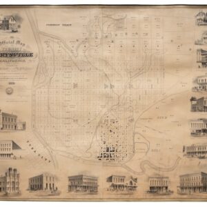
Official Map of the City of Marysville, California. Compiled by N. Wescoatt, City Surveyor, and W. S. Watson, Civil Engineer, from Recent Surveys by N. Wescoatt.
- An exceptional and monumental Gold Rush-era city plan of one of early California’s most prosperous river ports at its peak.
- Read moreQuick View
-