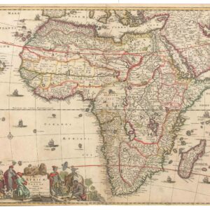
Cornelius de Jode’s superb 1593 map of Africa.
Africae Vera Forma, et Situs
Out of stock
Description
Africae Vera Forma, et Situs (The true shape and situation of Africa) is a finely-executed copperplate production. The title, placed at the top in large lettering, is flanked by intricate jeweled strapwork bands. Balancing out West Africa on the right side of the page is a text box with seventeen lines of descriptive text about Africa. The map is richly adorned with ships and sea monsters and various vignettes scattered across the map.
As usual for contemporary maps of Africa, there is a significant gap between the accuracy and detail of the coast, and the lack of detail and invention of the interior of the continent. This map retains the coastal outline from Gastaldi, with the interior based primarily on Mercator’s world map of 1569. This is most evident in the river systems, including Sachaf lac as the source of the Zabere (Zembere), Cuama and R. d S. Spirito rivers in southern Africa. The map also incorporates information from Ortelius, including the placement of Zanzibar on the southwest coast.
Verso Text: Latin
Cartographer(s):
Gerard de Jode (1511–91) was a Dutch printer and mapmaker born in Nijmegen who worked from Antwerp, then the center of European cartographic production. Accepted into the Guild of St. Luke in 1547, he quickly earned a reputation as a skilled mapmaker — though his business acumen never quite matched his cartographic talent. His greatest achievement was the two-volume Speculum Orbis Terrarum (1578), conceived as a rival to Ortelius’ enormously popular Theatrum Orbis Terrarum. Despite De Jode’s reputation, the atlas sold poorly — a commercial failure whose consequence is that barely a dozen copies survive today, making it one of the rarest atlases in existence.
Undeterred, De Jode began work on a revised and expanded atlas with his son Cornelis (1568–1600). The result, Speculum Orbis Terrae (1593), retained Gerard’s original maps while incorporating significant revisions and new maps compiled by Cornelis. Gerard died two years before publication. The atlas fared no better commercially, and after Cornelis’ death the plates were sold to J. B. Vrients — who also owned the Ortelius plates — effectively ensuring the work would never be reprinted. Where Ortelius ran to dozens of editions, the De Jode atlas exists only in its two original editions of 1578 and 1593.
Condition Description
A clear impression on watermarked paper, with little fading, no tears and only minor marginal soiling.
References
Betz, Richard L. The Mapping of Africa: A Cartobibliography of Printed Maps of the African Continent to 1700. Goy-Houten: Hes De Graaf, 2007, #27.
Norwich, I., and Pam Kolbe. Maps of Africa: An Illustrated and Annotated Carto-bibliography. Johannesburg: Ad. Donker, 1983, #19.